

New York map
Morrisania map
A printable two-page map of Morrisania (The Bronx, New York), drawn by VisitorFun from OpenStreetMap. Page two is the street index: every street on the sheet with its grid square, the same list as below.
Open the map (PDF, US Letter)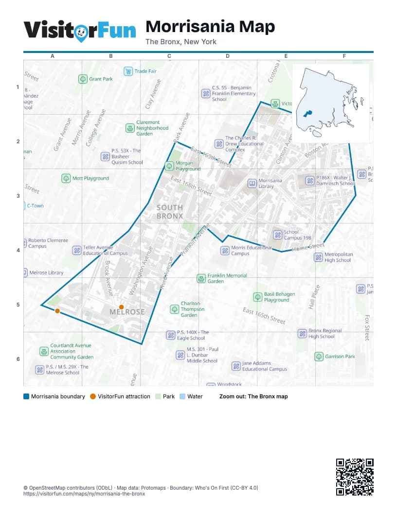
Street index of Morrisania
Each street on the sheet and the grid squares it crosses.
- Cottage PlaceE1, E2
- Crotona Park SouthE1, E2, F2
- Franklin AvenueE1, D3
- Washington AvenueC2, C3, C4, B5
- East 169th StreetD2, D3, E3
- Third AvenueD2, C3
- Boston RoadE2, F2, D3, E3
- Clinton AvenueE2, E3
- Crotona AvenueE2, F2
- Jefferson PlaceE2
- Chisholm StreetF2, F3
- Crotona Park EastF2
- East 170th StreetF2
- Prospect AvenueF2, F3, E4
- East 167th StreetC3, C4
- Gouverneur PlaceC3, C4
- Park AvenueC3, B4, A5
- East 168th StreetD3, E4
- Forest AvenueD3
- Fulton AvenueD3, C4
- Jackson AvenueD3, D4
- Freeman StreetE3, F3
- Jennings StreetE3, F3
- Ritter PlaceE3, F3
- Tinton AvenueE3
- Union AvenueE3, E4
- Bristow StreetF3
- Lyman PlaceF3, F4
- Reverend James A. Polite AvenueF3
- Brook AvenueB4, B5, B6
- East 164th StreetB4, B5, C5
- East 165th StreetB4, C4
- Melrose AvenueB4, A5, B5
- Weiher CourtB4
- East 166th StreetC4
- Home StreetD4, E4
- Courtlandt AvenueA5, B5
- East 161st StreetA5, B5, B6
- East 162nd StreetA5, B5
- East 163rd StreetA5, B5
- Elton AvenueB5
Things to do on the Morrisania map
Places on the map
- Bronx-Lebanon Hospital Center Fulton Division
- C.S.132 - Garrett A. Morgan School
- Christian and Missionary Church
- Claremont Park Congregation
- El Coqui Liberation Community Garden
- FDNY EMS Station 26
- FDNY Engine 50/Ladder 19
- Futa Islamic Center, Inc.
- Harriet Tubman Charter School
- McDonald's
- Melrose Commons Park
- Morgan Playground
- Morrisania Houses
- Morrisania Library
- Mount of Blessing SDA Church
- P.S. 110 - The Theodore Schoenfeld School
- P.S. 63 - Author's Academy & Mott Hall Charter School
- P186X - Walter J. Damrosch School
- Proposed intergenerational permanent housing
- School Campus 198
- Second Disciples of Christ Church
© OpenStreetMap contributors (ODbL) · Map data: Protomaps · Boundary: Who's On First (CC-BY 4.0)