

New York map
Oakwood map
A printable two-page map of Oakwood (Staten Island, New York), drawn by VisitorFun from OpenStreetMap. Page two is the street index: every street on the sheet with its grid square, the same list as below.
Open the map (PDF, US Letter)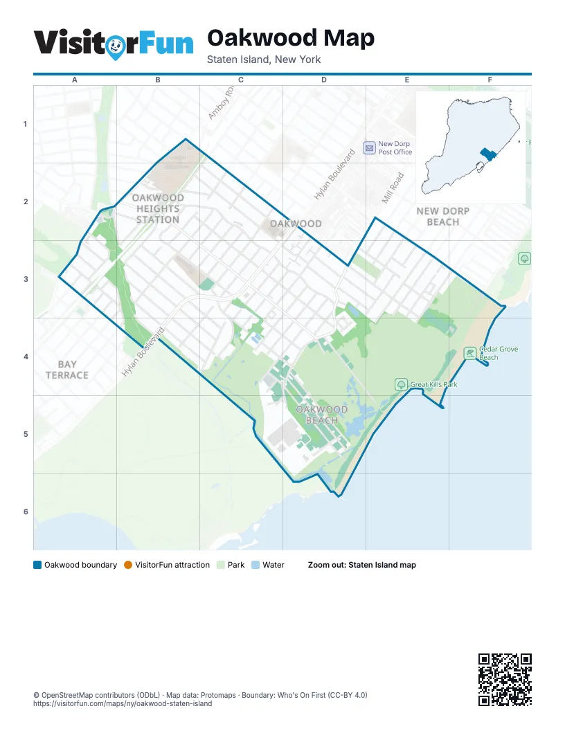
Street index of Oakwood
Each street on the sheet and the grid squares it crosses.
- Amber StreetB1
- Amboy RoadB1, B2, A3
- East BroadwayB1
- Park StreetB1
- Clark StreetA2
- Hafstrom StreetA2, A3
- Montreal AvenueA2, A3, B3, C4
- Riedel AvenueA2, B3
- Savoy StreetA2
- Windemere AvenueA2, B2
- Acorn StreetB2
- Adelaide AvenueB2, B3, C3, C4, D4
- Cedarview AvenueB2
- Clarence PlaceB2, C2
- Erwin CourtB2
- Farrell CourtB2
- Guyon AvenueB2, D4
- Isabella AvenueB2, C2, C3, D3, D4
- Leeds StreetB2, C2, B3
- North Railroad AvenueB2, A3, B3
- Oak AvenueB2, C2, C3, D3
- Peter AvenueB2, C2, C3, D3
- South Railroad AvenueB2, A3, B3
- Tarring StreetB2, B3
- Thomas StreetB2
- Wolverine StreetB2
- 10th StreetC2
- 8th StreetC2
- Clawson StreetC2, C3
- Elmira StreetC2, B3
- Flint StreetC2, C3
- Penn AvenueC2, D2, D3
- Whitehall StreetC2, B3
- Hylan BoulevardD2, B3, C3, B4
- Cuba AvenueE2, E3
- Ebbitts StreetE2, E3, F3
- Mill RoadE2, D3, D4, C5, D5
- Titus AvenueE2, E3
- Buffalo StreetA3
- Chesterton AvenueA3, B3, B4, C4
- Emmet AvenueA3, B3, B4
- Fairbanks AvenueA3, B3, B4, C4
- O'Gorman AvenueA3
- Sheridan CourtA3
- Tatro StreetA3, B3
- Twombly AvenueA3
- Champlain AvenueB3
- Currie AvenueB3, B4
- Hooper AvenueB3, A4
- Malone AvenueB3, C4
- Peel PlaceB3
- Platt StreetB3
- Aviston StreetC3, C4, D4
- Brook AvenueC3, C4
- Falcon AvenueC3, D3, C4
- Ithaca StreetC3
- Malden PlaceC3, D3
- Medina StreetC3, C4
- Pendale StreetC3, B4
- Tarrytown AvenueC3, D3, C4
- Amherst AvenueD3, C4
- Barry CourtD3
- Eva AvenueD3, E3
- Foss AvenueD3
- Lynn StreetD3, C4
- Pelican CircleD3, D4
- Primrose PlaceD3
- Riga StreetD3, C4, D4
- Roberts DriveD3, E3
- Stoneham StreetD3, D4
- Tysens LaneD3, E3
- Diaz PlaceE3
- Finley AvenueE3
- Hett AvenueE3
- Isernia AvenueE3
- Jennifer LaneE3
- Manila AvenueE3
- Manila PlaceE3
- Michelle LaneE3
- Milton AvenueE3, E4
- Navesink PlaceE3
- Roma AvenueE3, F3, E4
- Weed AvenueE3
- Cedar Grove AvenueF3, F4, D5
- Cedar Grove Beach PlaceF3, E4, F4
- Durant AvenueB4
- Dugdale StreetC4, D4
- Grayson StreetC4
- Merkel PlaceC4
- Fox LaneD4, D5
- Foxbeach AvenueD4, D5
- Kissam AvenueD4, E5
- Promenade AvenueD4
- Tarlton StreetD4, D5
- Delwit AvenueC5, D5
- Fox Beach AvenueD5
- Great Kills LaneD5
- Mill LaneD5
Places on the map
- Carolina Gardens Apartments
- Cedar Grove Beach
- Clawson Playground
- Gerard P. Dugan Park
- Great Kills Park
- Monsignor Farrell High School
- Oakwood Beach
- Oakwood Beach Wetlands Area
- Oakwood Heights
- Oakwood Heights Community Church
- P.S. 50 - Frank Hankinson School
- Richmond County
- Saint Charles Catholic Church
- Saint Charles School
- Santander
Next to Oakwood
- Bay Terrace
- New Dorp Beach map
© OpenStreetMap contributors (ODbL) · Map data: Protomaps · Boundary: Who's On First (CC-BY 4.0)