

New York map
Olean map
About 13,614 people live here (Census Bureau, 2024 estimate). The sheet's index lists 266 streets; Southern Tier Expressway, North Union Street and Buffalo Street cross the most grid squares. Also on it: Mount View Cemetery, Olean General Hospital and Forness Park.
Open the map (PDF, US Letter)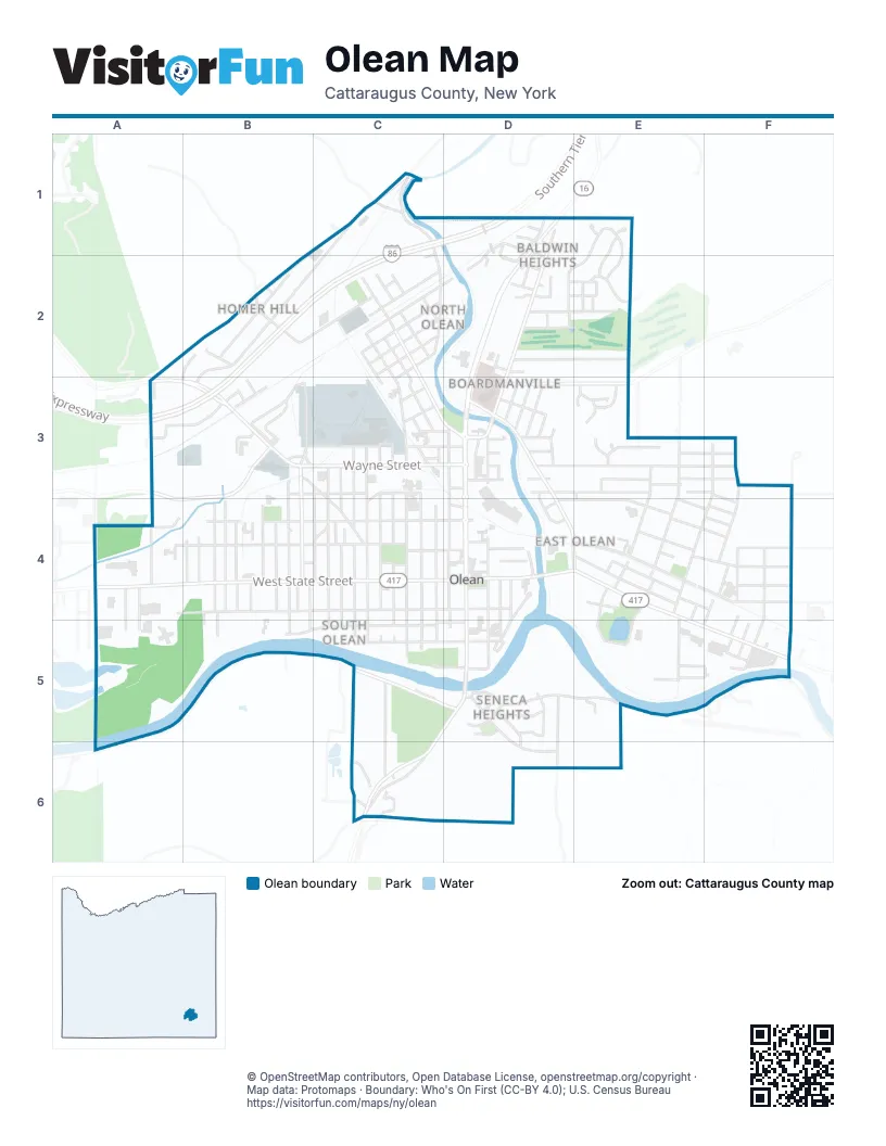
Street index of Olean
Each street on the sheet and the grid squares it crosses.
- Homer AlleyC1, C2
- Homer StreetC1, B2, B3
- Oregon RoadC1
- River StreetC1, C2
- Southern Tier ExpresswayC1, D1, B2, C2, A3, B3
- Baldwin AvenueD1
- Delevan AvenueD1
- Elmore StreetD1
- Erie StreetD1, D2
- Fairview AvenueD1, D2
- Main StreetD1, D2, D3
- North Union StreetD1, C2, D2, C3, D3, D4
- Pleasant StreetD1, D2
- Thorn StreetD1, D2
- West Baldwin AvenueD1, D2
- West StreetD1, D2
- Gemini DriveE1, E2
- Satellite CircleE1
- Skyview DriveE1
- Stardust LaneE1, D2, E2
- Avenue AB2, B3
- Edgewood AvenueB2, A3
- Fountain StreetB2
- Franklin StreetB2, C2
- Hilltop StreetB2
- Johnson RoadB2
- Johnson StreetB2
- Ash StreetC2
- East Connell StreetC2
- East Elm StreetC2
- East Forest AvenueC2
- East Oak StreetC2
- East Pine StreetC2, D2
- East Water StreetC2
- Franklin AlleyC2
- Maple StreetC2, C3
- Martin StreetC2
- Spruce StreetC2, C3
- Vine StreetC2, C3
- Walnut StreetC2
- West Connell StreetC2, B3
- West Elm StreetC2
- West Forest AvenueC2, C3
- West Oak StreetC2
- West Water StreetC2
- Arland AvenueD2
- East Baldwin AvenueD2
- East Oviatt StreetD2
- Euclid AvenueD2, E2
- Hamilton AvenueD2, E2
- Highland ParkwayD2
- Highland TerraceD2
- Linwood AvenueD2
- Madison AvenueD2, E2
- Monroe StreetD2
- Oviatt StreetD2
- Pancio LaneD2
- Rosedale TerraceD2
- Tyler AvenueD2, E2
- Van Buren AvenueD2, E2
- Willow StreetD2
- Wilson DriveD2
- Buchanan AvenueE2
- Mountainview DriveE2
- Sunrise DriveE2
- Terrace StreetE2, E3
- Buffalo RoadA3
- Buffalo StreetA3, B3, C3, C4
- Constitution AvenueA3, B3, A4
- Fall AvenueA3
- Lundys LaneA3
- West Fall RoadA3, B3
- Avenue BB3
- East Fall RoadB3
- Lincoln StreetB3
- Moore AvenueB3
- North 12th StreetB3, B4
- North 13th StreetB3, B4
- Reed StreetB3, C3, D3, C4
- Wayne StreetB3, C3, D3
- West Norton DriveB3
- Brickell AvenueC3
- Brookview AvenueC3
- Coleman StreetC3, D3
- Gardiner AvenueC3
- Halpine AlleyC3
- Keating AvenueC3
- North 10th StreetC3, C4
- North 11th StreetC3, C4
- North 3rd StreetC3, C4
- North 4th StreetC3, C4
- North 5th StreetC3, C4
- North 6th StreetC3, C4
- North 7th StreetC3, C4
- North 8th StreetC3, C4
- North 9th StreetC3, C4
- Penn AvenueC3
- Root StreetC3, D3
- Van Campen AvenueC3
- 1st AvenueD3
- 2nd AvenueD3
- 3rd AvenueD3
- 4th AvenueD3
- 5th AvenueD3
- Albany AvenueD3
- Center StreetD3
- Delaware AvenueD3, E3, F3
- Delaware Park CenterD3
- Front StreetD3, D4, E4
- Genesee StreetD3, E3
- Gilmore AvenueD3, D4
- Higgins AvenueD3
- Highland AvenueD3, E3
- North 1st StreetD3, D4
- North Barry StreetD3, D4
- Orange AvenueD3
- Orleans AvenueD3
- Palace StreetD3
- Paragon AvenueD3
- Prospect AvenueD3, E3, F3
- School StreetD3
- Alder StreetE3, E4
- Division StreetE3
- Forest Hill AvenueE3
- Grandview AvenueE3
- Grandview CourtE3
- Inwood DriveE3
- Kingston DriveE3, F3
- Loops LaneE3
- Park AvenueE3, F3
- Plymouth StreetE3
- Queen StreetE3, E4
- Sycamore StreetE3, E4
- Woodview AvenueE3
- Woodview CourtE3
- Cherry StreetF3, F4
- Donnelly AvenueF3, F4
- Gulf StreetF3, F4
- King StreetF3, E4, F4
- Independence DriveA4
- North 28th StreetA4
- South 25th StreetA4, A5
- South 26th StreetA4, A5
- South 28th StreetA4
- Washington StreetA4, B4, C4
- West Henley StreetA4, B4, C4, D4
- West State StreetA4, B4, C4
- West Sullivan StreetA4, B4, C4, D4
- North 14th StreetB4
- North 15th StreetB4
- North 17th StreetB4
- North 18th StreetB4
- North 19th StreetB4
- North 20th StreetB4
- North 21st StreetB4
- Olds CourtB4
- Putnam StreetB4, C4
- South 11th StreetB4, B5
- South 12th StreetB4
- South 13th StreetB4, B5
- South 14th StreetB4
- South 16th StreetB4
- South 17th StreetB4
- South 18th StreetB4
- South 19th StreetB4, B5
- South 20th StreetB4, B5
- Anderson AvenueC4
- Burger PlaceC4
- Laurens StreetC4, D4
- North 2nd StreetC4
- South 10th StreetC4, C5
- South 2nd StreetC4, C5
- South 3rd StreetC4, C5
- South 4th StreetC4, C5
- South 5th StreetC4, C5
- South 6th StreetC4, C5
- South 7th StreetC4, C5
- South 8th StreetC4, C5
- South 9th StreetC4, C5
- State Highway 417C4, D4
- Winters AvenueC4
- Worden AvenueC4
- Adams StreetD4, D5
- Armory PlaceD4
- Bluebird SquareD4
- East AvenueD4
- East Henley StreetD4
- East Spring StreetD4, E4
- East State StreetD4, E4, E5, F5
- East Sullivan StreetD4
- Fulton StreetD4
- Hamilton StreetD4
- Jay StreetD4
- Laurel AvenueD4
- North Clinton StreetD4
- South 1st StreetD4, D5
- South Barry StreetD4, D5
- South Clinton StreetD4, D5
- South StreetD4
- South Union StreetD4, D5, C6
- Spring StreetD4
- Times SquareD4
- Tompkins StreetD4
- Whitney AvenueD4
- Bell StreetE4, F4
- Bishop StreetE4
- Brook StreetE4, F4
- Chestnut StreetE4, E5
- Crown StreetE4, F4
- Davis StreetE4
- Garden AvenueE4
- Griffin StreetE4, F4
- Grossman AvenueE4, E5
- Hoop StreetE4
- Orchard AvenueE4
- Prince StreetE4
- Rowland AvenueE4, E5
- Seneca AvenueE4, F4
- Stowell AvenueE4, E5
- Tracy StreetE4
- Charles StreetF4, F5
- Duke StreetF4, F5
- Elayne StreetF4
- Forness AvenueF4
- Goodrich AvenueF4
- Houghton AvenueF4
- Line StreetF4
- North Clark StreetF4, F5
- Plum StreetF4
- Irving ParkwayB5
- Irving StreetB5, C5, D5
- Franchot BoulevardC5, D5
- Martha AvenueC5, C6
- West Greene StreetC5, D5
- West Riverside DriveC5, D5
- Bradley DriveD5, E5
- Carolina StreetD5
- East Greene StreetD5
- East Ohio StreetD5
- East Riverside DriveD5, E5
- Edwards CourtD5
- Garfield CourtD5
- Grant CourtD5
- Indiana AvenueD5, D6
- Monroe TerraceD5
- Vermont StreetD5, D6
- Virginia StreetD5
- West Ohio StreetD5
- York StreetD5, D6
- Billington AvenueE5, F5
- Dean StreetE5, F5
- Osgood AvenueE5
- James StreetF5
- Jefferson StreetF5
- Niagara StreetF5
- Olean-Portville RoadF5
- Richmond StreetF5
- South Clark StreetF5
- Taggerty AvenueF5
- Wright StreetF5
- Allen StreetC6
- Alpine RoadC6
- Austin CourtC6
- Mc Cann Hollow RoadC6
- South AvenueC6
- South Union BranchC6
Places on the map
- (Formerly) Archbishop Walsh HS
- 7-Eleven
- ALDI
- American Legion Hall
- ASAP Drain Cleaning
- Basilica of Saint Mary of the Angels
- Bethany Lutheran Church
- Bethel Assembly of God Church
- Bethel Baptist Church
- Boardman Park
- Boardmanville Elementary School
- Bradner Stadium
- Cornerstone Full Gospel Church
- Forness Park
- Four Mile Brewing, LLC
- Franchot Field
- Franklin-Hysol Park
- Hampton Inn & Suites
- Holiday Inn Express
- Jamestown Community College Cattaraugus County Campus
- King Street Park
- Magnano Park
- Marcus Park
- McDonald's
- Mount View Cemetery
- Oak Hill Park
- Old Library Restaurant
- Olean Food Barn
- Olean General Heliport
- Olean General Hospital
- Olean Municipal Building
- Olean Post Office
- Olean Public Library
- Olean Teachers & Postal CU
- Orlean Church
- Perkins
- Riverview Park
- Saint John Catholic Church
- Tops
- War Veterans Park
© OpenStreetMap contributors, Open Database License, openstreetmap.org/copyright · Map data: Protomaps · Boundary: Who's On First (CC-BY 4.0); U.S. Census Bureau















