

New York map
Olean map
About 13,614 people live here (Census Bureau, 2024 estimate). The sheet's index lists 86 streets; Southern Tier Expressway, Wayman Branch Road and Oregon Road cross the most grid squares. Also on it: Camel Back, Flatiron Rock and Giermek Executive Airport.
Open the map (PDF, US Letter)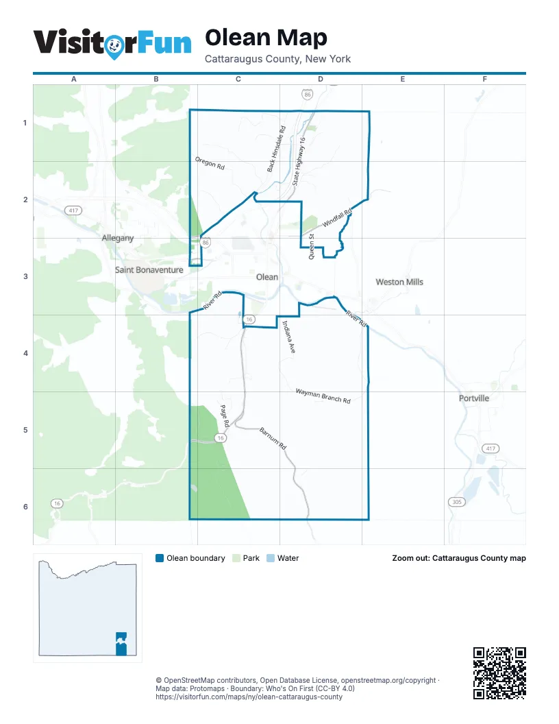
Street index of Olean
Each street on the sheet and the grid squares it crosses.
- Oregon RoadB1, C1, C2
- Back Hinsdale RoadC1, D1, C2
- Blakeslee Hollow RoadC1, C2
- Hastings Road WestC1, D1
- Struble Hollow RoadC1, D1
- Stubler Hollow RoadC1, D1
- Fairview AvenueD1
- Godfrey Hollow RoadD1, D2
- Hastings RoadD1
- Hastings Road EastD1
- Kansas AvenueD1
- Michigan AvenueD1
- Montana StreetD1
- Nevada AvenueD1
- Oakes RoadD1, C2, D2
- Schott AvenueD1
- Southern Tier ExpresswayD1, C2, D2, B3, C3
- State Highway 16D1, D2
- Union Valley RoadD1
- Buffalo RoadB2, C2
- Edgewood AvenueC2
- Homer StreetC2
- Johnson RoadC2
- Parkside DriveC2, B3, C3
- River StreetC2
- Belle Vue LaneD2
- David DriveD2
- Dugan RoadD2
- Genesee StreetD2
- Hayes RoadD2
- Hillcrest AvenueD2, D3
- North Union StreetD2
- Old Route 16D2
- Old Rte 16D2
- Queen StreetD2, D3
- Red Oak DriveD2
- Sunrise DriveD2
- Terrace StreetD2
- Windfall RoadD2, E2
- West Windfall RoadE2
- Constitution AvenueB3, C3
- Independence DriveB3
- West River RoadB3, C3
- Camelback LaneC3, C4
- Fall AvenueC3
- North 24th StreetC3
- North 28th StreetC3
- West Riverside DriveC3
- Cherry StreetD3
- Delaware AvenueD3
- East River RoadD3, D4, E4
- East Riverside DriveD3
- Gulf StreetD3
- Kingston DriveD3
- Prospect AvenueD3
- Mc Cann Hollow RoadB4, C4
- Alpine DriveC4
- Alpine RoadC4
- Hillside DriveC4
- Indiana AvenueC4, D4
- Kamery RoadC4
- Mueller RoadC4
- Newbury LaneC4
- Page RoadC4, C5
- Rock City Hill RoadC4
- South AvenueC4
- South Union StreetC4
- State Highway 16 SouthC4, B5, C5
- Stoneybrook RoadC4
- V R Soy DriveC4
- Ward LaneC4, C5
- Wildcat RoadC4
- Steam Valley RoadD4, E4
- Wayman Branch RoadD4, E4, D5, E5
- Two Mile RoadB5, C5
- Barnum RoadC5, D5, D6
- Doc McDuffy RoadC5
- East Page RoadC5
- Indian Creek RoadC5, C6
- Macduffy RoadC5
- Songer DriveC5
- Swarts RoadC5
- Whites GlenC5
- Hartwig RoadD5
- North Branch RoadC6
- Big Loop Mountain RoadD6
Places on the map
- B'nai B'rith Cemetery
- Camel Back
- Flatiron Rock
- Giermek Executive Airport
- Hartzfelt Mountain
- Homer Hill
- Mount Herman
- Old Baldy
- Paul Wise Hill
- Pleasant Valley Cemetery
- Town Of Olean Volunteer Fire Department
Next to Olean
- Allegany
- Portville
- Saint Bonaventure
- Weston Mills
© OpenStreetMap contributors, Open Database License, openstreetmap.org/copyright · Map data: Protomaps · Boundary: Who's On First (CC-BY 4.0)















