

New York map
Pleasant Plains map
A printable two-page map of Pleasant Plains (Staten Island, New York), drawn by VisitorFun from OpenStreetMap. Page two is the street index: every street on the sheet with its grid square, the same list as below.
Open the map (PDF, US Letter)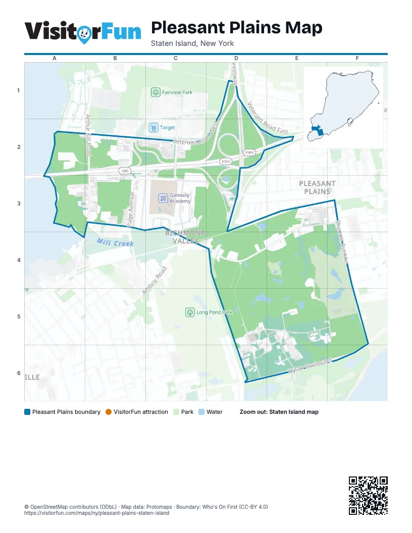
Street index of Pleasant Plains
Each street on the sheet and the grid squares it crosses.
- Bricktown WayD1
- Englewood AvenueD1
- Veterans Road WestD1, B2, C2, D2
- West Shore ExpresswayD1, B2, C2, D2
- Allentown LaneA2
- Korean War Veterans ParkwayB2, C2, D2, E2
- North Bridge StreetB2
- Outerbridge CrossingB2, C2
- South Bridge StreetB2, B3
- Tyrellan AvenueC2, C3
- Arthur Kill RoadB3, A4
- Boscombe AvenueB3, C3, D3
- Page AvenueB3
- Richmond Valley RoadB3, C3, C4, D4
- Butler StreetC3
- Cole StreetC3
- Frosinone LaneC3
- Madsen AvenueC3
- Meade LoopC3
- Richmond PlaceC3, C4
- Torrice LoopC3
- Weiner StreetC3, C4
- Amboy RoadE3, D4, E4
- Bedell StreetE3, F3
- Gilbert PlaceE3, F3
- Penton StreetE3, F3
- Latourette StreetF3
- Sharrott AvenueF3, F4, F5
- Kenneth PlaceF4
- Stevenson PlaceF4
- Cunningham RoadD5
- Kenny RoadE5, E6
- Sherwood AvenueF5
- Hylan BoulevardE6, F6
Places on the map
- Amboy Plaza
- Bridgeview Plaza
- Cemetery of the Resurrection
- Charleston Place
- Gateway Academy
- Lazio Villas
- Mill Creek Bluebelt
- MIV at Mount Loretto
- North Mount Loretto State Forest
- Outerbridge Park & Ride
- P.S. / I.S. 25R - South Richmond High School
- Page Plaza
- Parking Lot 1
- Parking Lot 4
- Pleasant Plains
- Richmond Valley Commons
- Richmond Valley Plaza
- South Shore Commons
- St. Joacim and Ann Church
- Sunoco
- Super Fresh
- United States Postal Service
© OpenStreetMap contributors (ODbL) · Map data: Protomaps · Boundary: Who's On First (CC-BY 4.0)