

New York map
Port Morris map
A printable two-page map of Port Morris (The Bronx, New York), drawn by VisitorFun from OpenStreetMap. Page two is the street index: every street on the sheet with its grid square, the same list as below.
Open the map (PDF, US Letter)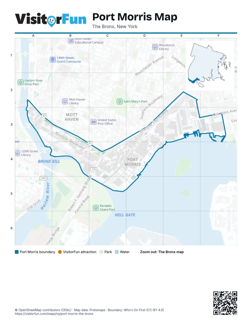
Street index of Port Morris
Each street on the sheet and the grid squares it crosses.
- East 135th StreetA2, A3, C4, D4
- Exterior StreetA2
- Park AvenueA2
- Austin PlaceE2
- Barry StreetE2, E3
- Bruckner BoulevardE2, A3, B3, C3, D3, E3, B4, C4
- Bruckner ExpresswayE2, C3, D3, E3, C4
- Leggett AvenueE2
- Timpson PlaceE2
- Alexander AvenueA3
- East 132nd StreetA3, B3, B4, C4, D5
- East 134th StreetA3, B3, B4, C4, D4
- Lincoln AvenueA3
- Major Deegan ExpresswayA3, B3
- Third AvenueA3
- Third Avenue BridgeA3
- Brown PlaceB3, B4
- Willis AvenueB3
- Willis Avenue BridgeB3, B4
- East 139th StreetC3, D4
- East 140th StreetD3, D4
- East 141st StreetD3, D4
- East 149th StreetD3, E3
- Southern BoulevardD3
- Walnut AvenueD3, C4, D4
- Oak Point AvenueE3, F3
- Craven StreetF3
- Dupont StreetF3
- Tiffany StreetF3
- Truxton StreetF3
- Worthen StreetF3
- Brook AvenueB4
- East 130th StreetB4, C4
- Saint Ann's AvenueB4
- Cypress AvenueC4
- Cypress PlaceC4
- East 130 StreetC4, C5
- East 133rd StreetC4, D5
- East 136th StreetC4, D4
- East 137th StreetC4, D4
- East 138th StreetC4, D4
- Robert F. Kennedy BridgeC4, C5
- Saint Ann's PlaceC4
- Willow AvenueC4
- Locust AvenueD4, D5
- East 129 StreetC5
Places on the map
- Action Environmental Services
- Bankside
- Bronx Brewery
- CubeSmart
- FoodFest Depot
- Harlem River Yard Power Station
- Hell Gate power station
- Oak Point Yard
- Playground One Thirty Four CXXXIV
- Pulaski Park
- Roman Auto Tech
- U-Haul
Next to Port Morris
© OpenStreetMap contributors (ODbL) · Map data: Protomaps · Boundary: Who's On First (CC-BY 4.0)