

New York map
Port Richmond map
A printable two-page map of Port Richmond (Staten Island, New York), drawn by VisitorFun from OpenStreetMap. Page two is the street index: every street on the sheet with its grid square, the same list as below.
Open the map (PDF, US Letter)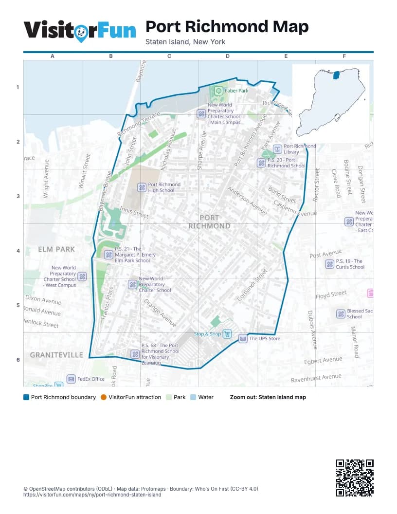
Street index of Port Richmond
Each street on the sheet and the grid squares it crosses.
- Nicholas AvenueC1, C2, C3, B4
- Richmond TerraceC1, D1, E1, B2, C2
- Treadwell AvenueC1, C2, C3, C4
- Faber StreetD1, D2, D3
- Kirkland CourtD1, D2
- Maple AvenueD1, D2
- North StreetD1
- Sharpe AvenueD1, D2, C3, D3
- Ferry StreetE1
- Gales LaneE1
- Port Richmond AvenueE1, D2, E2, D3, C4, B5, C5, B6
- John StreetB2, B3
- Newark AvenueB2, B3
- Riverside LaneB2, C2
- Bayonne CourtC2
- Edgeview LaneC2
- Harrison AvenueC2, D2
- Openview LaneC2
- Slaight StreetC2
- Bennett StreetD2, E2
- Grove AvenueD2
- Larkin StreetD2
- New StreetD2, E3
- Vreeland StreetD2, E2, E3
- Ann StreetE2
- Avenue BE2, E3
- Church StreetE2
- Cottage PlaceE2, E3
- Heberton AvenueE2, D3, E3, D4, C5
- Jewett AvenueE2, E3, E4, E5
- Park AvenueE2, D3
- Wygant PlaceE2
- Bayonne BridgeB3, B4
- Dr. Martin Luther King Jr. ExpresswayB3, B4, B5, B6
- Eaton PlaceB3
- Innis StreetB3, C3
- Saint Josephs AvenueB3, C3
- Trantor PlaceB3, B4, B5, B6
- Blackford AvenueC3, C4
- Castleton AvenueC3, D3, E3
- Charles AvenueC3, D3
- Clinton PlaceC3, C4, D4
- Crittenden PlaceC3
- Grove PlaceC3
- Hatfield PlaceC3, D4
- Palmer AvenueC3, D3, D4, E4
- Albion PlaceD3, E4
- Anderson AvenueD3, E3
- Post AvenueD3, D4, E4
- Bond StreetE3
- Simonson PlaceE3, E4
- Washington PlaceE3, E4
- Hooker PlaceB4, C4
- Sage CourtB4
- Villa AvenueB4, B5, B6
- Walker StreetB4, C4, C5
- Burden AvenueC4
- Catherine StreetC4, D5
- Homestead AvenueC4, D4
- LaForge AvenueC4
- LaForge PlaceC4
- Lagrange PlaceC4, C5
- Rainbow AvenueC4, D4
- Decker AvenueD4, C5, D5, C6
- Lexington AvenueD4, E4, D5
- Catherine CourtE4
- Cortlandt StreetE4, D5
- Mitchel LaneE4, E5
- Dixon AvenueB5
- Hagaman PlaceB5, C6
- Linda CourtB5, C5
- Seymour AvenueB5, C5
- Tate StreetB5
- Van Riper StreetB5, B6
- Barrett AvenueC5, D6
- Beekman StreetC5
- Cornell StreetC5, D5
- Montell StreetC5, D5
- Orange AvenueC5
- Riley PlaceC5
- Tabb PlaceC5
- Borg CourtD5
- Dryden CourtD5
- Hamlin PlaceD5
- Haughwout AvenueD5, E5
- Newkirk AvenueD5
- Sharrett PlaceD5
- Bache StreetE5
- Derby CourtE5
- Holbernt CourtE5
- Kramer PlaceE5
- Forest AvenueB6, C6, D6
- Rumpler CourtB6, C6
- Smith PlaceB6, C6
- Willowbrook RoadB6
- Veltman AvenueD6
Places on the map
- Bridgeview Apartments
- Faber Park
- Faber Pool
- Faith United Methodist Church
- Forest Avenue Shoppers Town
- Key Food
- Kingdom Hall of Jehovah's Witnesses
- New World Preparatory Charter School
- New World Preparatory Charter School - Main Campus
- P.S. 20 - Port Richmond School
- P.S. 21 - The Margaret P. Emery Elm Park School
- P.S. 68 - The Port Richmond School for Visionary Learning
- Port Richmond High School
- Port Richmond Library
- Port Richmond Post Office
- Port Village
- Reformed Church on Staten Island Cemetery
- Saint Lukes Church
- Saint Roch Catholic Church
- St. John's Lutheran Church
- St. John's Lutheran Church Cemetery
- St. Mary's of the Assumption Church Cemetery
- St. Mary's Orthodox Church
- Staten Island Reformed Church
- Stop & Shop
- Temple Emanu-El
- The Mar Thoma Church Staten Island
Next to Port Richmond
- Elm Park
- Graniteville map
© OpenStreetMap contributors (ODbL) · Map data: Protomaps · Boundary: Who's On First (CC-BY 4.0)