

New York map
Rosebank map
A printable two-page map of Rosebank (Staten Island, New York), drawn by VisitorFun from OpenStreetMap. Page two is the street index: every street on the sheet with its grid square, the same list as below.
Open the map (PDF, US Letter)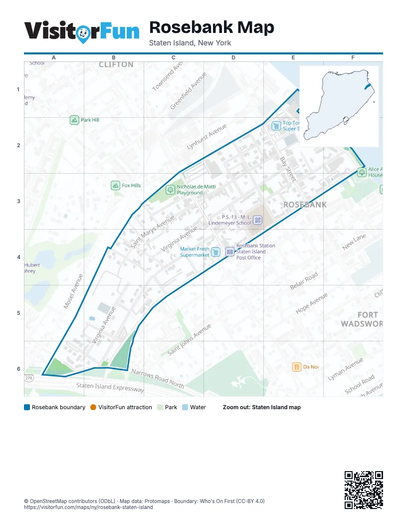
Street index of Rosebank
Each street on the sheet and the grid squares it crosses.
- Chestnut AvenueC2, D2
- Tompkins AvenueC2, C3, D4
- Anderson StreetD2, D3, E3
- Butler PlaceD2
- Kaltenmeier LaneD2
- Ormond PlaceD2, E2
- Saint Marys AvenueD2, E2, C3, D3, B4, C4
- Tilson PlaceD2, D3
- Bay StreetE2, E3
- Church LaneE2
- Clifton AvenueE2, F2, D3, E3, C4, B5, B6
- Edgewater StreetE2, F2
- Sylva LaneE2, F2
- Sylvaton TerraceE2
- Virginia AvenueE2, D3, B4, C4, B5, A6, B6
- Wiman PlaceE2
- Hylan BoulevardF2, E3, C4, D4, B5, C5, B6
- Bell StreetB3, B4
- Oak StreetB3, B4
- Smith StreetB3, C4
- Shaughnessy LaneC3
- White Plains AvenueC3, C4
- Vermont AvenueD3, D4
- Vienna CourtD3, D4
- Rosebank PlaceE3
- Fletcher StreetB4, C4
- Reynolds StreetB4, C4
- Amity StreetC4
- Fox Hill TerraceC4
- Reynolds CourtC4, C5
- Vaughan StreetC4, D4
- Tone LaneA5, B5, B6
- Colton StreetB5
- Donley AvenueB5, B6
- Kay PlaceC5
- Maryland PlaceC5
- Kansas AvenueA6
- Narrows Road NorthA6, B6
- Rockwell AvenueA6, B6
Places on the map
- Church of Saint Joseph
- Fox Hills Battery Station
- Market Fresh Supermarket
- Nicholas de Matti Playground
- P.S. 13 - M. L. Lindemeyer School
- Rosebank Station Staten Island Post Office
- Saint Mary's Roman Catholic Church
- Tompkins Plaza
- Top Tomato Super Store
Next to Rosebank
- Clifton
- Fort Wadsworth map
© OpenStreetMap contributors (ODbL) · Map data: Protomaps · Boundary: Who's On First (CC-BY 4.0)