

New York map
Unionport map
A printable two-page map of Unionport (The Bronx, New York), drawn by VisitorFun from OpenStreetMap. Page two is the street index: every street on the sheet with its grid square, the same list as below.
Open the map (PDF, US Letter)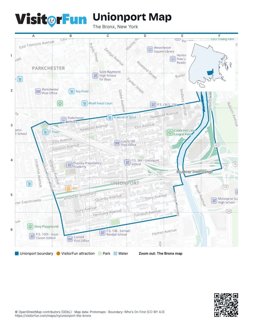
Street index of Unionport
Each street on the sheet and the grid squares it crosses.
- Ferris PlaceE1
- East Tremont AvenueF1
- Hutchinson River ParkwayF1, F2, F3, F4
- Tan PlaceF1
- Commerce AvenueE2, F2, E3, E4
- Halsey StreetE2
- Waterbury AvenueE2
- Cross Bronx ExpresswayA3, C4, D4, E4, F4, E5
- East 177th StreetA3, B3, B4, C4, D4, E4
- Hugh J. Grant CircleA3
- Newbold AvenueA3, B3, C3, D3, E3
- Virginia AvenueA3, A4, B5
- Westchester AvenueA3, B3
- White Plains RoadA3, B5, B6
- Ellis AvenueB3, C3, D3, E3, A4
- Pugsley AvenueB3, B4, B5
- Castle Hill AvenueC3, C4, C5, D5
- Gleason AvenueC3, D3, E3, A4, B4
- Olmstead AvenueC3, C4, C5
- Powell AvenueE3, A4, B4, C4, D4
- Seabury AvenueE3
- Zerega AvenueE3, E4
- Haviland AvenueA4, C4, D4, E4
- Watson AvenueB4, C4, D4, E4
- Blackrock AvenueC4, D4, E4, B5
- Chatterton AvenueC4, D4, E4, B5
- Bruckner BoulevardD4, E4, F4, B5, C5, D5, E5
- Bruckner ExpresswayD4, E4, F4, C5, D5
- Havemeyer AvenueD4, D5
- Brush AvenueE4
- Quimby AvenueB5, C5, D5, E5
- Story AvenueB5, C5, D5, E5
- Hermany AvenueC5, D5, E5, B6
- Turnbull AvenueD5, E5, B6, C6, D6
- Lafayette AvenueB6
Places on the map
- A world of Spice
- C Town
- Castle Hill Avenue
- Castle Hill Library
- Castle Hill Little League Field
- Castle Hill Post Office
- Church of the Holy Family
- FDNY Engine 64;Ladder 47
- Fourth Presbyterian Church
- Herbert H. Lehman Educational Campus
- Iglesia De Dios Pentecostal
- KFC
- McDonald's
- P.S. 119X - The Dr. Emmett W. Bassett School
- P.S. 36X - Unionport School
- Parkchester
- Pugsley Preparatory Academy
Next to Unionport
- Parkchester
© OpenStreetMap contributors (ODbL) · Map data: Protomaps · Boundary: Who's On First (CC-BY 4.0)