

New York map
Wakefield map
A printable two-page map of Wakefield (The Bronx, New York), drawn by VisitorFun from OpenStreetMap. Page two is the street index: every street on the sheet with its grid square, the same list as below.
Open the map (PDF, US Letter)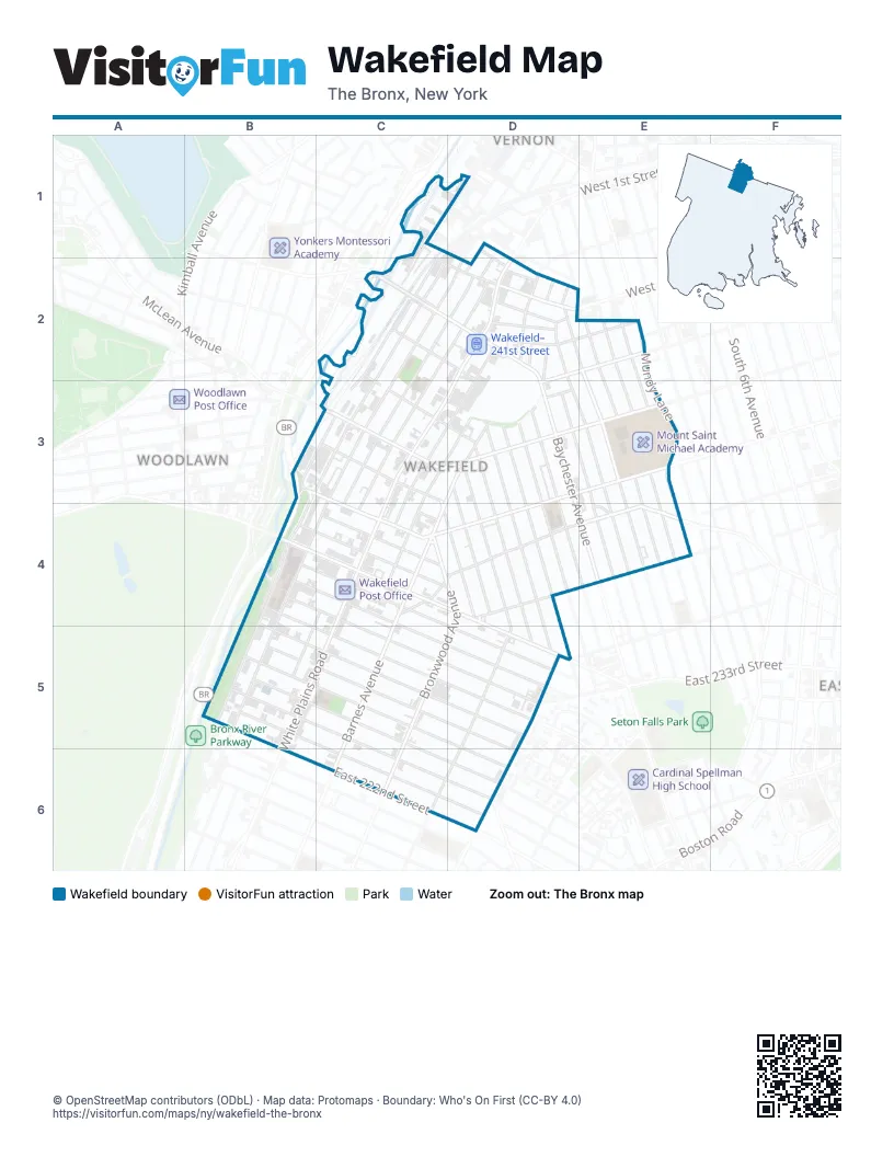
Street index of Wakefield
Each street on the sheet and the grid squares it crosses.
- Baldwin StreetC1, D1
- Pearl StreetC1
- East 243rd StreetD1, D2
- Osgood StreetD1, D2
- South MacQuesten ParkwayD1
- Bronx BoulevardC2, B3, C3, B4, B5
- Bronx River ParkwayC2, B3, B4
- Bullard AvenueC2, B3, C3
- Carpenter AvenueC2, D2, C3, B4, B5
- East 239th StreetC2, C3, D3
- East 240th StreetC2, D2
- East 241st StreetC2, D2, E2, D3
- East 242nd StreetC2, D2
- Matilda AvenueC2, D2, C3, C4
- Richardson AvenueC2, D2, C3, C4
- Wakefield AvenueC2
- Barnes AvenueD2, C3, D3, C4, C5
- Beach StreetD2
- Cranford AvenueD2, E2
- Furman AvenueD2, C3, C4
- Hoxie StreetD2, D3
- Murdock AvenueD2, E2, E3
- Osman PlaceD2
- Penfield StreetD2
- Robertson StreetD2
- Saint Ouen StreetD2
- West 1st StreetD2
- West 3rd StreetD2
- White Plains RoadD2, C3, D3
- Wilder AvenueD2, E3
- Hill AvenueE2, E3, E4
- Monticello AvenueE2, E3
- Mundy LaneE2, E3
- Seton AvenueE2, E3
- East 236th StreetB3, C3, C4
- Byron AvenueC3, D3, C4
- East 237th StreetC3
- Nereid AvenueC3, D3, E3
- Baychester AvenueD3
- Bissel AvenueD3
- Boyd AvenueD3, D4
- Bruner AvenueD3, D4, D5
- Camp StreetD3
- De Reimer AvenueD3, E3, E4
- Edson AvenueD3
- Ely AvenueD3, D4, D5
- Grace AvenueD3
- Gunther AvenueD3, D4, D5
- Pitman AvenueD3, E3, C4, D4
- Wickham AvenueD3, D5
- Bushnell PlaceE3
- Seton Avenue - Mundy LaneE3, E4
- South 11th AvenueE3
- West 5th StreetE3
- East 228th StreetB4, D5
- East 229th StreetB4, C5, D5
- East 230th StreetB4, D5
- East 231st StreetB4, D5
- East 232nd StreetB4, C4, D5
- East 233rd StreetB4, D4, D5
- East 234th StreetB4, D4
- Bronxwood AvenueC4, D4, C5, D5, C6
- Bussing AvenueC4, D4, E4
- Digney AvenueC4, D4
- East 235th StreetC4
- Lowerre PlaceC4, B5
- Old White Plains RoadC4
- Whitehall PlaceC4
- Edenwald AvenueD4, E4
- Bussing PlaceE4
- Kingsbridge Road WestE4
- East 222nd StreetB5, B6
- East 223rd StreetB5, C6, D6
- East 224th StreetB5, D6
- East 225th StreetB5, D6
- East 226th StreetB5, C5, D6
- East 227th StreetB5, C5, D5
- Carvel Parking LotD5
- Laconia AvenueD5, D6
- Paulding AvenueD5
Places on the map
- 225th Street
- 233rd Street
- 239th Street Yard
- Bronx Bethany Church of the Nazarene
- Burger King
- Butler Memorial Methodist Church
- Church of the Good Shepherd
- FDNY Engine 63/Ladder 39
- Fine Fare
- Food Town
- Foodverse Market
- Key Food
- Laconia Community Church
- McDonald's
- Montefiore Medical Center - Wakefield Campus
- Mount Saint Michael Academy
- Nereid Avenue
- Our Lady of Grace Roman Catholic Church
- P.S. 103 - Hector Fontanez School
- P.S. 16 - Wakefield School
- P.S. 21X - The Philip H. Sheridan School
- P.S. 483 - The Matilda Avenue School
- P.S. 87X
- Saint Frances of Rome Catholic Church
- Wakefield Grace United Methodist Church
- Wakefield Library
- Wakefield Playground
- Wakefield Post Office
- Wakefield-241st Street
- Wakefield–241st Street
Next to Wakefield
- Woodlawn
© OpenStreetMap contributors (ODbL) · Map data: Protomaps · Boundary: Who's On First (CC-BY 4.0)