

New York map
West Farms map
A printable two-page map of West Farms (The Bronx, New York), drawn by VisitorFun from OpenStreetMap. Page two is the street index: every street on the sheet with its grid square, the same list as below.
Open the map (PDF, US Letter)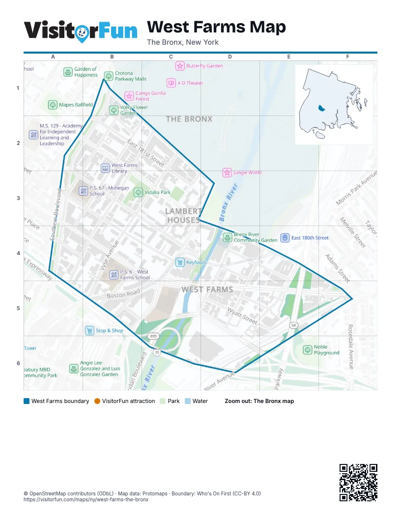
Street index of West Farms
Each street on the sheet and the grid squares it crosses.
- Bronx Park SouthB1, C2, C3, D3
- Crotona ParkwayB1, A2, B2, A4
- East 182nd StreetB1
- Hornaday PlaceB1, B2
- Mohegan AvenueB1, A3
- Nereid AvenueB1
- Southern BoulevardB1, A2, B2
- East 180th StreetA2, B2, C3, D4, E4, F4, F5
- Marmion AvenueA2
- East 181st StreetB2, C3
- Daly AvenueC2, B3, A4, B4, A5
- Honeywell AvenueC2, B3, A4
- Vyse AvenueC2, B4, B5
- East 178th StreetA3, B4, C4, D5, E5
- East 179th StreetA3, B3, C4, D4
- Boston RoadC3, D3, C4, B5, C5
- Bryant AvenueC3, B4, C4, B5
- Elsmere PlaceA4
- Fairmount PlaceA4
- East Tremont AvenueC4, C5, D5, E5, F5
- Devoe AvenueD4, C5, D5
- Lebanon StreetD4, E4
- McDonald's Drive ThroughD4
- McDonald's Parking LotD4, D5
- Bronx Park AvenueE4, D5
- Bronx River ParkwayE4, E5
- Morris Park AvenueE4, D5, E5
- Cross Bronx Expressway Service RoadA5, B5
- Longfellow AvenueB5
- Rodman PlaceB5
- West Farms RoadB5, C5
- East 177th StreetC5, D5, D6, E6
- Sheridan BoulevardC5, C6
- Wyatt StreetD5, E5
- Van Nest AvenueE5, F5
- Cross Bronx ExpresswayC6, D6
Places on the map
- Bronx River Arts Center
- Bronx River Community Garden
- Drew Gardens
- Emmanuel Swedish Evangelical Church
- FDNY Engine 45/Ladder 58/Battalion 18
- Keyfoods
- McDonald's Drive Through
- Old West Farms Soldiers Cemetery
- P.S. 214 - The Lorraine Hansberry Academy
- P.S. 6 - West Farms School
- P.S. 67 - Mohegan School
- Saint Thomas Aquinas Catholic Church
- Vidalia Park
- Volky Flower Garden
- West Farms Library
- West Farms Post Office
- West Farms Rapids Park
- West Farms Square-East Tremont Avenue
Next to West Farms
© OpenStreetMap contributors (ODbL) · Map data: Protomaps · Boundary: Who's On First (CC-BY 4.0)