

New York map
Westchester map
A printable two-page map of Westchester (The Bronx, New York), drawn by VisitorFun from OpenStreetMap. Page two is the street index: every street on the sheet with its grid square, the same list as below.
Open the map (PDF, US Letter)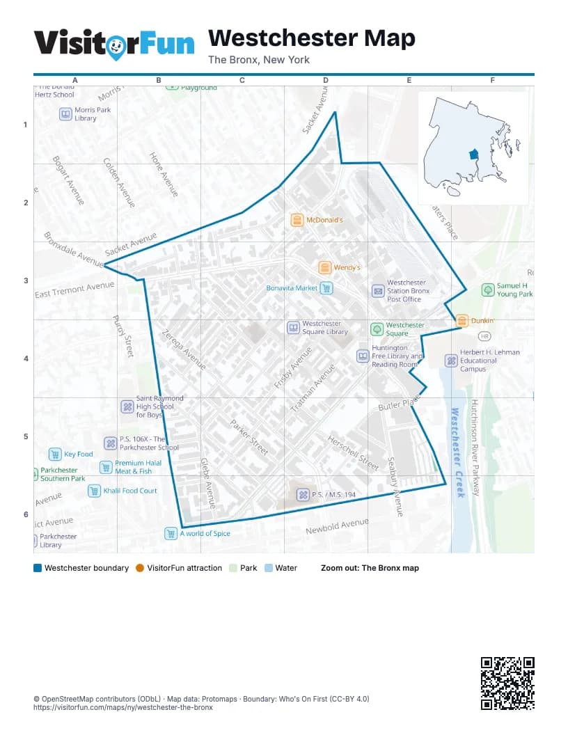
Street index of Westchester
Each street on the sheet and the grid squares it crosses.
- Eastchester RoadD1, D2
- Waters PlaceD1
- Hone AvenueB2, B3
- Lurting AvenueC2, C3
- Poplar StreetC2, D2, B3
- Roselle StreetC2, C3
- Williamsbridge RoadC2, D2, D3
- Blondell AvenueD2, E3, E4
- Chesbrough AvenueD2
- Jarrett PlaceD2
- McDonald's Drive ThroughD2
- Saint Raymonds AvenueD2, D3, C4, B5
- Silver StreetD2, C3
- Bronxdale AvenueA3, B3
- Castle Hill AvenueB3, B6
- East Tremont AvenueB3, C3, D3, E3, E4, F4
- Lyvere StreetB3, B4
- Paulding AvenueB3
- Seddon StreetB3, C3, C4
- Benson StreetC3, D3, D4, E4
- Buck StreetC3, B4
- Fuller StreetC3, B4
- Maclay AvenueC3, D3, B4, C4
- Marvin PlaceC3
- Montgomery PlaceC3
- Overing StreetC3, D4
- Saint Peters AvenueC3, C4, D5
- Chase Bank Parking LotD3
- Frisby AvenueD3, C4, D4, C5
- Glebe AvenueD3, C4, B5, C5, C6
- Halperin AvenueD3, E3
- Ponton AvenueD3, E3
- Roberts AvenueD3, E3
- Wendy's Drive ThroughD3
- Wendy's Parking LotD3
- Cooper AvenueE3
- East Tremont Avenue / Westchester SquareE3, E4
- Fink AvenueE3, E4
- Lane AvenueE3, D4, E4
- Tan PlaceE3
- Waters AvenueF3
- Glover StreetB4, B5, C5, C6
- Parker StreetB4, C5, D6
- Stearns StreetB4, B5
- Zerega AvenueB4, C4, C5, D5
- Dorsey StreetC4
- Hubbell StreetC4
- Rowland StreetC4, D5
- Seabury AvenueD4, E5
- Tratman AvenueD4, C5
- Butler PlaceE4, D5, E5
- Commerce AvenueE4
- Ferris PlaceE4
- Westchester AvenueE4, C5, B6, C6
- Manning StreetB5
- Doris StreetC5, C6
- Lyon AvenueC5, C6
- Starling AvenueC5
- Halsey StreetD5, E5, D6
- Herschell StreetD5, E5
- Rowe StreetD5, E5
- Havemeyer AvenueC6
- Waterbury AvenueC6, E6
Places on the map
- AutoZone
- Bonavita Market
- Huntington Free Library and Reading Room
- McDonald's
- Montefiore Westchester Square Campus
- Montifore Medical Park - Einstein Campus
- P.12X - The Lewis and Clark School
- P.S. / M.S. 194
- Saint Peter's Episcopal Church
- Saint Peter's Graveyard
- Wendy's
- Westchester Methodist Church
- Westchester Square
- Westchester Square Library
- Westchester Square-East Tremont Avenue
- Westchester Station Bronx Post Office
- Westchester Yard
- Zerega Avenue
© OpenStreetMap contributors (ODbL) · Map data: Protomaps · Boundary: Who's On First (CC-BY 4.0)