

New York map
Westerleigh map
A printable two-page map of Westerleigh (Staten Island, New York), drawn by VisitorFun from OpenStreetMap. Page two is the street index: every street on the sheet with its grid square, the same list as below.
Open the map (PDF, US Letter)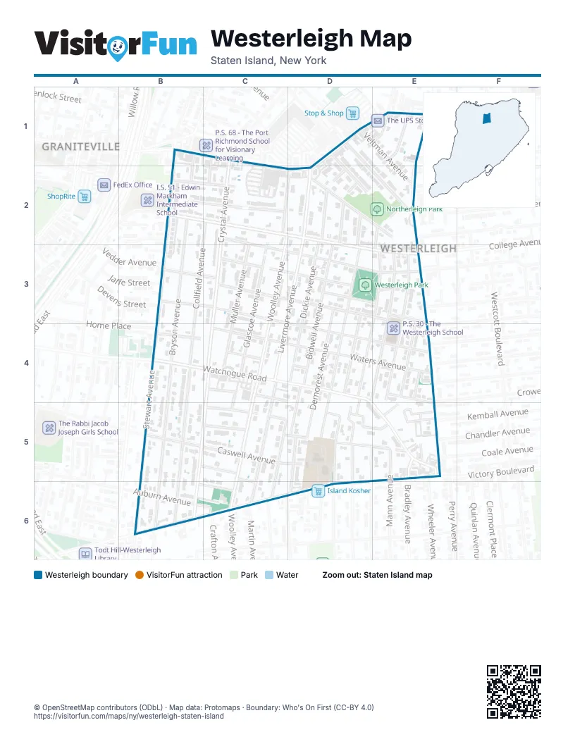
Street index of Westerleigh
Each street on the sheet and the grid squares it crosses.
- Arnprior StreetB1, B2
- Forest AvenueB1, C1, D1, E1, C2, D2
- Willowbrook RoadB1, B2, B3
- Crystal AvenueC1, C2, C3, C4, B5, B6
- Decker AvenueC1
- Pontiac StreetC1, C2
- Barrett AvenueD1
- Burnside AvenueD1, E2
- Eldridge AvenueD1, D2
- Hamlin PlaceE1
- Ordell AvenueE1
- Veltman AvenueE1, E2
- Bryson AvenueB2, B3, B4, B5, B6
- College AvenueB2, C2, D2, D3, E3
- Galloway AvenueB2, C2
- Gloria CourtB2
- Houston StreetB2
- Riegelmann StreetB2, C2
- Willowbrook CourtB2
- Collfield AvenueC2, B4, B5, B6
- Maine AvenueC2, C3, D3, E3
- Marianne StreetC2, D2
- Muller AvenueC2, C4
- Bidwell AvenueD2, D4
- Clark PlaceD2
- Dickie AvenueD2, D3, D4
- Livermore AvenueD2, D3, C4, C5, C6
- Neal Dow AvenueD2, D3, D4, D5
- North AvenueD2, E2
- Saint Anthony PlaceD2
- Woolley AvenueD2, C4, C5, C6
- Jewett AvenueE2
- Lockwood PlaceE2, E3
- Ravenhurst AvenueE2
- Shaw PlaceE2
- College CourtB3
- Devens StreetB3
- Jaffe StreetB3
- Lathrop AvenueB3, C3, D3, E3
- Leonard AvenueB3, C3, D4, E4
- Vedder AvenueB3
- Garrison AvenueC3, D3
- Glascoe AvenueC3, C4
- Demorest AvenueD3, D5
- Saint John AvenueD3, D4
- Springfield AvenueD3, E3
- Deems AvenueE3, E4
- Fiske AvenueE3, D5
- The BoulevardE3
- Wardwell AvenueE3, E4
- Willard AvenueE3, D4
- Woodbridge PlaceE3
- Home PlaceB4
- Watchogue RoadB4, C4, D4, D5, E5
- Waters AvenueB4, C4, D4
- Columbus PlaceC4, D4
- Earley AvenueC4, C5
- Ruth StreetC4
- Wade StreetC4
- Avon LaneD4, D5
- Cheves AvenueD4, D5
- Dakota PlaceE4
- Markham PlaceE4
- Caswell AvenueB5, C5, D5
- Fillat StreetB5, C5
- Stewart AvenueB5, B6
- Delmore StreetC5
- Dora StreetC5
- Harvey AvenueC5, C6
- Marble StreetC5, D5, E5
- Wilbur PlaceC5, C6
- Frederick StreetD5, E5
- Ingram AvenueD5, D6
- Iowa PlaceD5
- Kell AvenueD5
- O'Connor AvenueD5, D6
- Seward PlaceD5
- Bradley AvenueE5
- Byrne AvenueE5
- Mann AvenueE5
- Smith CourtE5
- Treetz PlaceE5
- Victory BoulevardE5, B6, C6, D6
- Vogel LaneE5
- Vogel LoopE5
- Auburn AvenueB6, C6
- Decatur AvenueB6
- Gurdon StreetB6, C6
- Ardmore AvenueC6
- Crafton AvenueC6
- Martin AvenueC6
- Sheraden AvenueC6
- Carmel AvenueD6
Places on the map
- 24 Hour Laundromat
- 4Ever Beauty Supply
- 7-Eleven
- Aadobe Animal Hospital
- All Saints' Episcopal Church
- BCB Bank
- Boba Le Tea Cafe
- BP
- BP Shop
- Buffet Don Pollo Mexican Food
- Burger King
- Camelot
- Chase
- China New Star Restaurant
- Chocolate & Balloons Galore
- Church of the Holy Family
- Cicero's
- Cricket Wireless
- Dorado Pharmacy
- Dr. Scafuri & Associates
- El Bethel Assemblies of God
- Eldridge Dental Care
- Elite Barber Studio
- Exalt Studio
- Eyes & Optics
- Forest Avenue & Burnside Avenue
- Forest Avenue & Crystal Avenue
- Forest Avenue & Livermore Avenue
- Frank & Gerry Barbershop
- G's Cheesesteaks
- Island Hair Braiding
- J & E Nails Spa
- Jeff's Barbershop
- Jewett Avenue & Egbert Avenue
- Joseph Ashley Nail Studio
- Kebab Grill & Detox Juice Bar
- La Casa Del Taco
- Laundry Express
- Learn & Discover Playschool
- Los Rosas Deli & Grocery
Next to Westerleigh
© OpenStreetMap contributors (ODbL) · Map data: Protomaps · Boundary: Who's On First (CC-BY 4.0)