

New York map
Williamsbridge map
A printable two-page map of Williamsbridge (The Bronx, New York), drawn by VisitorFun from OpenStreetMap. Page two is the street index: every street on the sheet with its grid square, the same list as below.
Open the map (PDF, US Letter)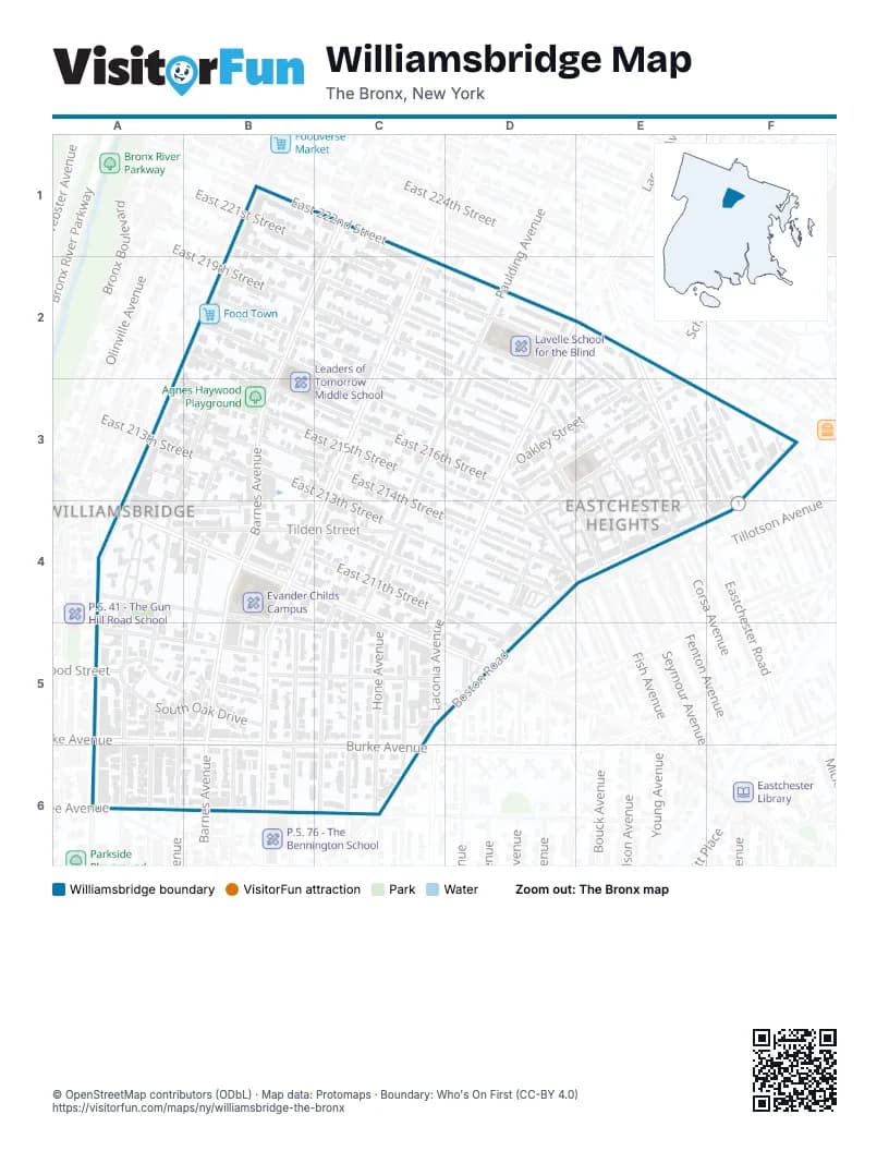
Street index of Williamsbridge
Each street on the sheet and the grid squares it crosses.
- Barnes AvenueC1, B2, C2, B3, B4, B5
- East 216th StreetB2, B3, C3, D3
- East 217th StreetB2, C3, D3
- East 218th StreetB2, C3, D3
- White Plains RoadB2, A3, A4
- Bronxwood AvenueC2, C3, B4, B5
- East 220th StreetD2, D3
- East 221st StreetD2, E2, E3
- Paulding AvenueD2, C3, D3, C4, C5
- Eastchester RoadE2, E3, E4
- Mickle AvenueE2, E3
- Oakley StreetE2, D3, E3
- Stickney PlaceE2, D3, E3
- East 211th StreetA3, A4, B4, D5
- East 212th StreetA3, C4, D4, D5
- East 213th StreetA3, B3, D4
- East 215th StreetA3, B3, C3, D4
- Carlisle PlaceB3, B4
- East 214th StreetB3, C3, D4
- Holland AvenueB3, A4, A5
- East 219th StreetD3
- Fenton AvenueD3, E3, E4
- Fish AvenueD3, E4
- Hicks StreetD3, E3, D4
- Laconia AvenueD3, C4, C5
- Needham AvenueD3, E3
- Wilson AvenueD3, D4
- Chester StreetE3, F3
- Corsa AvenueE3
- Seymour AvenueE3, E4
- Boston RoadF3, D4, E4, D5
- Gunther AvenueF3
- Kingsland AvenueF3
- Tiemann AvenueF3
- Cruger AvenueA4, A5
- East Gun Hill RoadA4
- Magenta StreetA4, B4, C5
- Tilden StreetA4, B4, C4
- Capuchin WayB4, B5
- Colden AvenueC4, C5, C6
- Hone AvenueC4, C6
- Bouck AvenueD4
- Monsignor Cahill PlaceD4
- North Oak DriveA5, B5
- Rosewood StreetA5
- South Oak DriveA5, B5
- Wallace AvenueA5, B5
- Bartholdi StreetB5
- Burke AvenueB5
- Chestnut StreetB5
- Duncan StreetB5, C5
- Matthews AvenueB5
- North Chestnut DriveB5
- Radcliff AvenueB5
- Lurting AvenueC5, C6
- Pearsall AvenueD5
- Yates AvenueD5
- Adee AvenueA6
- Lester StreetA6
- Williamsbridge RoadA6
Places on the map
- 211th Street Block Association Garden
- 219th Street
- Agnes Haywood Playground
- Burke Avenue
- Church of the Immaculate Conception
- Evander Childs Campus
- Fine Fare
- Food Town
- Gun Hill Houses
- Lavelle School for the Blind
- Leaders of Tomorrow Middle School
- P.S. 78 - The Anne Hutchinson School
- Saint Peter's Evangelical Lutheran Church
- Saint Philip and Saint James Church
- Williamsbridge Station Bronx Post Office
© OpenStreetMap contributors (ODbL) · Map data: Protomaps · Boundary: Who's On First (CC-BY 4.0)