

Ohio map
Akron Metro Area map
The sheet's index lists 32 highways; SR 14, I-76 and I-77 cross the most grid squares. Things to do inside the boundary: Akron Zoo, Cuyahoga Valley National Park and Downtown Akron Partnership. Also on it: Akron, Atwater and Aurora.
Open the map (PDF, US Letter)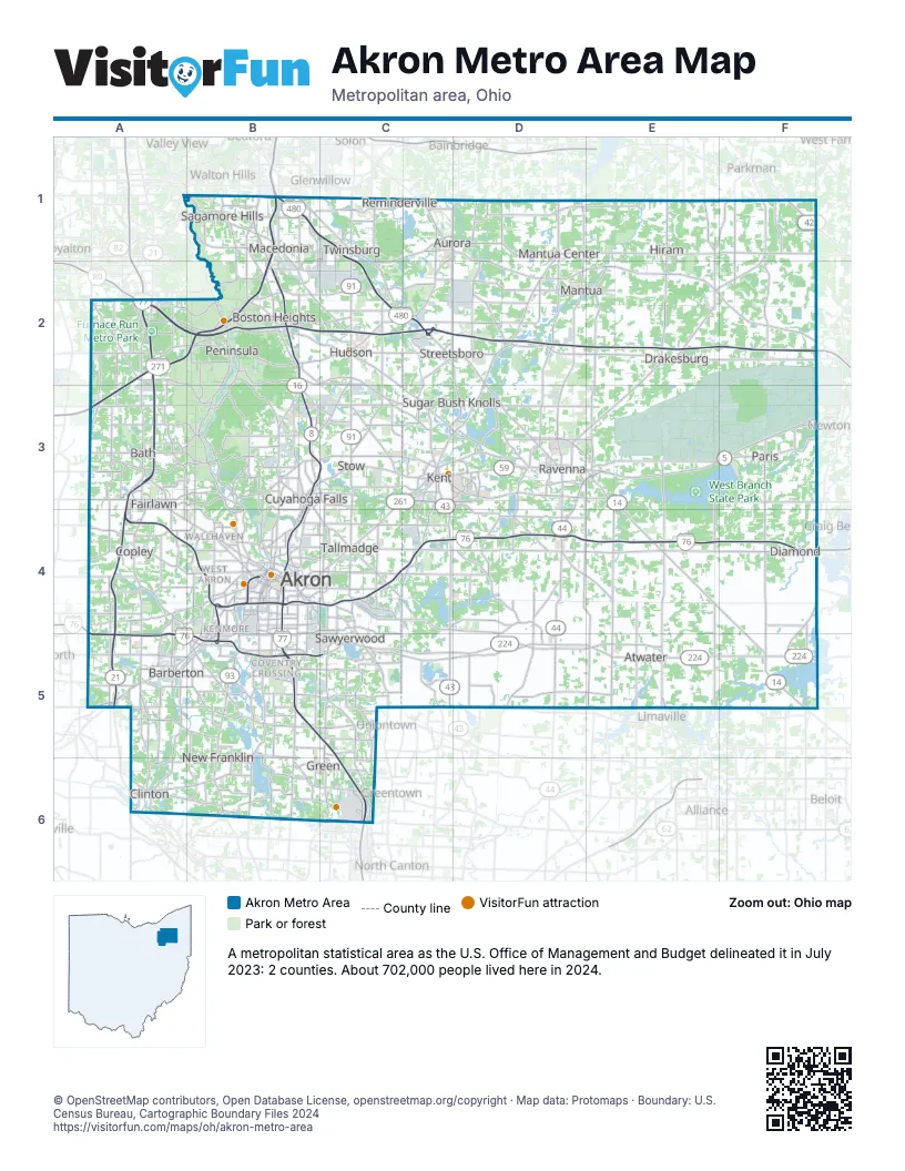
Highway index of Akron Metro Area
Each highway on the sheet and the grid squares it crosses.
- I-76A4, A5, B4, B5, C4, D4, E4, F4
- I-77A2, A3, A4, B4, B5, C5, C6
- I-80A2, B2, C2, D2, E2, F2
- I-271A2, A3, B1, B2
- I-277B5
- I-480B1, C1, C2
- US 224A4, A5, B5, C5, D5, E5, F5
- US 422F1
- SR 5D3, D4, E3, F3
- SR 8B1, B2, B3, B4, C3
- SR 14B1, C1, C2, D2, D3, E3, E4, F4, F5
- CH 16B2, B3
- SR 18A3, A4, B4, C4
- SR 21A2, A3, A4, A5
- SR 43C1, C2, C3, C4, C5, D2, D3
- SR 44D1, D2, D3, D4, D5, E3
- SR 59B3, B4, C3, D3, E3
- CH 66C5
- SR 82B1, C1, C2
- TH 90C4
- SR 91C1, C2, C3, C4, C5
- SR 93B5, B6
- SR 162B4
- SR 176A2
- SR 183E5
- SR 225E5, F5
- SR 241C5, C6
- SR 261B4, C3, C4, D3
- SR 303B2, C2, D2
- SR 306C1, D1
- SR 585A5
- SR 619B5, C5
Things to do on the Akron Metro Area map
Places on the map
- Akron
- Atwater
- Aurora
- Barberton
- Bath
- Boston Heights
- Clinton
- Copley
- Cuyahoga Falls
- Diamond
- Drakesburg
- Fairlawn
- Green
- Hiram
- Hudson
- Kent
- Macedonia
- Mantua
- Mantua Center
- New Franklin
- Paris
- Peninsula
- Ravenna
- Reminderville
- Sagamore Hills
- Sawyerwood
- Stow
- Streetsboro
- Sugar Bush Knolls
- Tallmadge
- Twinsburg
© OpenStreetMap contributors, Open Database License, openstreetmap.org/copyright · Map data: Protomaps · Boundary: U.S. Census Bureau, Cartographic Boundary Files 2024