

Ohio map
Bloom Township map
About 11,280 people live here (Census Bureau, 2024 estimate). The sheet's index lists 189 streets; Lithopolis Road Northwest, Amanda Northern Road Northwest and Alspach Road Northwest cross the most grid squares. Also on it: Chestnut Ridge Metro Park, Lithopolis and Lithopolis Cemetery.
Open the map (PDF, US Letter)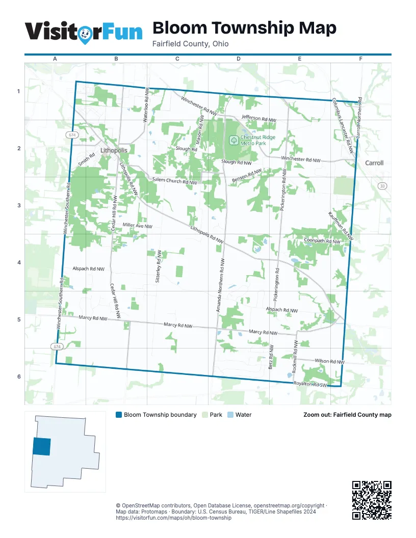
Street index of Bloom Township
Each street on the sheet and the grid squares it crosses.
- Ashbrook Village DriveA1, B1
- Blue Ash CourtA1
- Brooks Bend CourtA1
- Canal Winchester Road SouthA1, A2
- Creekside Crossing DriveA1
- Edgewater CourtA1
- Edgewater DriveA1, B1
- Faulkner DriveA1, B1
- Iris CourtA1
- Lithopolis RoadA1, A2, B2
- Orwell StreetA1, B1
- Poe AvenueA1
- Salinger DriveA1, B1
- Sandburg DriveA1, B1
- Streams End DriveA1, B1
- Twain AvenueA1
- Washington StreetA1
- White Ash CourtA1
- Ashbrook RoadB1
- Ashstone CourtB1
- Butterfield LaneB1
- Cooper's Hawk PlaceB1
- Hansberry DriveB1, B2
- Keller AvenueB1
- Lithopolis Winchester Road NorthwestB1, B2
- Marsh Hawk PlaceB1
- Mountain Ash LaneB1
- Red Shouldered DriveB1
- Red Tail DriveB1
- Waterloo Road NorthwestB1, B2
- Williamson LaneB1
- Diley Road NorthwestC1
- Mason Road NorthwestC1, C2, C3
- Winchester Road NorthwestC1, D1, D2, E2, F2
- Amanda Northern Road NorthwestD1, D2, D3, D4, D5, D6
- Jefferson Road NorthwestD1, E2
- Broad Street NorthwestE1
- High Street NorthwestE1
- Hummell Road NorthwestE1, E2
- Lockville RoadE1
- Lockville Road NorthwestE1
- Main Street NorthwestE1
- Pickerington Road NorthwestE1, E2, E3, E4
- Carroll Northern RoadF1, F2
- Columbus-Lancaster Road NorthwestF1, F2
- Pleasantville Road NorthwestF1
- Abbey AvenueA2
- Cherry Hill CourtA2
- Crestview DriveA2, B2
- Elder LaneA2, B2
- Green Forest PlaceA2
- Penny DriveA2
- Penny LaneA2
- Rolling Acre DriveA2, B2
- Smith RoadA2, B2
- Westview TerraceA2
- Winchester Southern RoadA2, A3, A4, A5, A6
- Bluebird LaneB2
- Brown StreetB2
- Cedar Hill Road NorthwestB2, B3, B4, B5, B6
- Cemetery RoadB2, F2
- Cherry AlleyB2
- Delaware StreetB2
- East Cherry AlleyB2
- East Columbus StreetB2
- East South StreetB2
- Hidden Valley LaneB2
- Hiddent Valley LaneB2
- Legion DriveB2
- Lithopolis Road NorthwestB2, B3, C3, C4, D4, E4, E5, F5
- Madolin DriveB2
- North Strawberry AlleyB2
- North StreetB2
- Plum AlleyB2
- Salem Church Road NorthwestB2, C2, D2, C3
- Slough RoadB2, C2
- South Market StreetB2
- South Strawberry AlleyB2
- Stoney Bluff WayB2
- Sycamore Bluff WayB2
- Twin Maple AvenueB2
- Wagnalls DriveB2
- WalnutB2
- Walnut StreetB2
- West Columbus StreetB2
- West North StreetB2
- West South StreetB2
- Wheatley DriveB2
- Ravine Drive NorthwestC2, C3
- Sharron Drive NorthwestC2
- Sitterley Road NorthwestC2, C3, C4, C5, C6
- Slough Road NorthwestC2, D2
- Smiley Drive NorthwestC2
- Timothy Lane NorthwestC2
- Vista Drive NorthwestC2
- Apple Barn Access Road (PRIVATE)D2
- Arbaugh Ridge Terrace NothwestD2, E2
- Benson Road NorthwestD2, D3
- Evergreen DriveD2
- Brandt Road NorthwestE2, E3, F3
- Castlewood Drive NorthwestE2, E3, F3
- King Arther CourtE2
- King Arthurs Court NorthwestE2
- Pine Hills Court NorthwestE2, E3
- Carroll-Southern Road NorthwestF2
- Feldon Court NorthwestF2
- High StreetF2
- Kauffman Road NorthwestF2, E3, F3, F4
- Miller Farm RunF2
- Cedar Hill Court NorthwestB3
- Miller Avenue NorthwestB3, C3
- Hocking TrailC3, C4
- Castleview PlaceD3
- Coonpath Road NorthwestD3, D4, E4, F4
- Greencastle Drive NorthwestD3
- Bartlett Road NorthwestE3
- Charity Street NorthwestE3
- Hope Drive NorthwestE3
- Countryview DriveF3
- Eagle DriveF3
- Fairway DriveF3
- Mulligan DriveF3
- Alspach Road NorthwestA4, B4, C4, C5, D5, E5
- Duvall RoadA4
- Slate Run VineyardA4
- Burr Oak Drive NorthwestB4
- Cedar Creek Drive NorthwestB4
- Cedar Way NorthwestB4
- Chickasaw RoadB4, B5
- Choctaw DriveB4, C4
- Faifield Farms DriveB4, B5, C5
- Julie Lynn Place NorthwestB4
- Lora LaneB4, B5
- Lora Lane Road NorthwestB4
- Sherry Ann Place NorthwestB4
- Hocking RunC4
- East Audubon Boulevard NorthwestD4, D5
- East Glenhurst Drive NorthwestD4, D5
- Heather Lake Drive NorthwestD4
- West Audubon Boulevard NorthwestD4, D5
- West Glenhurst Drive NorthwestD4, D5
- Wilshire Lane NorthwestD4
- Pickerington RoadE4, E5
- Plummer Road NorthwestE4, F4
- Woodale Drive NorthwestE4
- Woodale NorthwestE4
- Lamb Road NorthwestF4, F5
- Marcy RoadA5
- Marcy Road NorthwestA5, B5, C5, D5, E5
- West Slate Ridge Drive NorthwestA5, B5
- East Slate Ridge Drive NorthwestB5
- Old Carriage Court NorthwestB5
- Ottawa DriveB5
- Pheasant Run Drive NorthwestB5
- Pheasant Run Place NorthwestB5
- Red Fox Road NorthwestB5
- Red Fox StreetB5
- Stephens Court NorthwestB5
- Tracy Lynn Court NorthwestB5
- Ada Terrace NorthwestC5
- Chester Way NorthwestC5
- Ayrshire Court NorthwestD5
- Heidelberg Court NorthwestD5, D6
- Heister Road NorthwestD5
- Wittenberg Court NorthwestD5, D6
- Betz Road NorthwestE5, E6
- Bloomingwood Drive NorthwestE5
- Rockmill Road NorthwestE5, F5, E6
- Walker Drive NorthwestE5
- Patton LaneF5
- Rockmill PlaceF5
- Cedar Hill Road SouthwestB6
- Amanda Northern Road SouthwestD6
- Capital LaneD6
- Dennison Court NorthwestD6
- East Bowling Green Lane NorthwestD6
- East Ohio State Lane NorthwestD6
- Mount Union Court NorthwestD6
- North Wooster WayD6
- Oberlin CourtD6
- Ohio Northern Drive NorthwestD6, E6
- Ohio Wesleyan Court NorthwestD6
- Otterbein Trail NorthwestD6, E6
- West Bowling Green Lane NorthwestD6
- West Ohio State Lane NorthwestD6
- Edenborough Court NorthwestE6
- Rockmill Road SouthwestE6
- Royalton Road SouthwestE6
- Wilson Road NorthwestE6, F6
Places on the map
- American Legion Hall
- Betzer Cemetery
- Bloom Baptist Church
- Bloom Township Fire Station 551
- Bloom Township Fire Station 552
- Bloom Township Trustee Hall
- Bootsies
- Brick Cemetery
- Chestnut Ridge Metro Park
- Cook Pond
- Das KaffeeHaus von Frau Burkhart
- Eastside Athletics
- El' Pedregal
- Envy Nail Spa
- Faler Feed Store INC
- Greencastle Cemetery
- Hocking River ?
- Hoshor Cemetery
- Lithopolis
- Lithopolis Cemetery
- Lithopolis Post Office
- Lithopolis United Methodist Church
- Lockville Park
- Marathon Gas and Carry Out
- Moe Pond
- Morse Pond
- Old Betzer Cemetery
- Pine Hill Golf Course
- Pump Track
- Roller Field
- Salem Cemetery
- Salem Church
- Slate Run Dental
- Sunnyside Child Care
- The Old Blue Rooster Event Center LLC
- The Pump House
- The Wagnalls Memorial
- Tri County Family Physicians
- Village of Lithopolis Office
- Wesley Chapel Cemetery
Next to Bloom Township
- Carroll
© OpenStreetMap contributors, Open Database License, openstreetmap.org/copyright · Map data: Protomaps · Boundary: U.S. Census Bureau, TIGER/Line Shapefiles 2024















