

Ohio map
Fairfield County map
About 167,762 people live here (Census Bureau, 2024 estimate). The sheet's index lists 300 streets; Walnut Street, Maple Street and Lancaster-Kirkersville Road Northwest cross the most grid squares. Also on it: Amanda, Amanda Township and Baltimore.
Open the map (PDF, US Letter)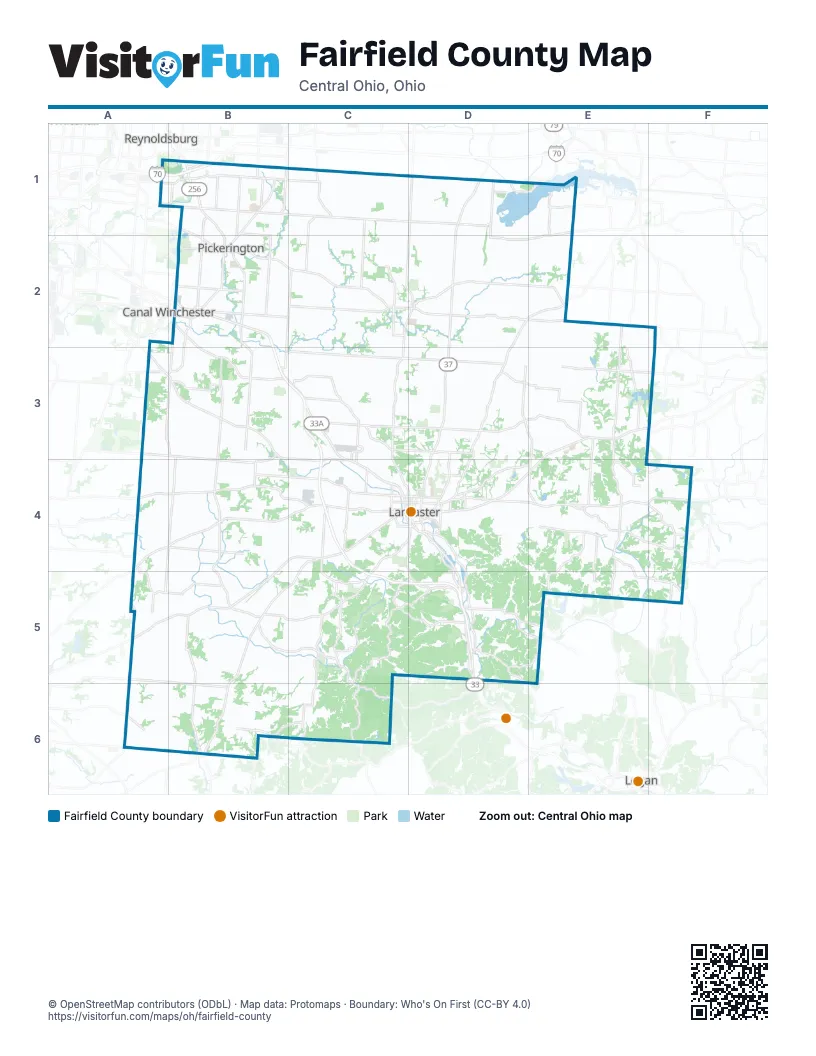
Maps inside Fairfield County
4 maps inside, from the street map of Fairfield County down.
Cities
Street index of Fairfield County
Each street on the sheet and the grid squares it crosses.
- Lancaster BypassC3, C4, C5, D5
- Columbus-Lancaster Road NorthwestB2, B3, C3, C4
- Logan-Lancaster RoadD4, D5
- Cincinnati-Zanesville Road SouthwestB4, C4, A5, B5
- Lancaster-Newark Road NortheastD1, D2, D3, D4
- Pickerington Road NorthwestB1, B2, B3
- Lithopolis Road NorthwestB3, C3, C4
- Baltimore-Somerset Road NortheastD2, E2, F2
- Diley RoadB1, B2
- Refugee RoadA1, B1, C1
- Cincinnati-Zanesville Road NortheastE3, F3, D4, E4
- Reynoldsburg Baltimore Road NorthwestB2, C2
- Hill Road NorthB1, B2
- North Memorial DriveC4
- East Main StreetD4, E4, B5
- Waterloo Road NorthwestB2, B3
- South Memorial DriveC4, D4
- West Columbus StreetB2, A3
- East Columbus StreetB2, A3, B3, D3
- Granville PikeD4
- West Market StreetC2, D2
- North High StreetC2, D4
- Walnut StreetA3, B3, D3, C4, D4, E4, A5
- West Main StreetC4, D4, E4, B5
- Lincoln AvenueB1, D3, C4
- Hill Road NorthwestB2
- Diley Road NorthwestB2
- Baltimore-Reynoldsburg RoadB1
- East Market StreetD2
- Lithopolis RoadA3
- Collins Road NorthwestC3, C4
- Kings CrossingB2
- Baltimore-Somerset RoadD2
- WalnutA3, B3
- Southeast ExpresswayB2
- Lancaster Road SouthwestD1
- Lancaster PikeA5
- Blacklick-Eastern Road NorthwestB1, C1, D1
- Lancaster-Kirkersville Road NorthwestD1, C2, D2, C3, C4
- Lancaster-Circleville Road SouthwestA4, B4, C4
- Chillicothe Lancaster Road SouthwestC4, B5, C5, B6
- Lancaster New Lexington Road NortheastD4, E4, F4
- Lancaster Thornville Road NortheastD2, E2, D3
- Logan-Thornville Road NortheastE2, E3, E4
- Winchester Road NorthwestB2, B3
- Winchester Southern Road SouthwestA4, A5
- Blacklick-Eastern Road NortheastD1, E1, D2, E2
- Marietta Road SoutheastE4, F4
- Amanda-Northern Road SouthwestB4, B5
- Winchester Southern RoadA3, A4, A5, A6
- Basil Western Road NorthwestC2
- Webb Summit Road SoutheastE4, E5, F5
- Basil Western RoadB2, C2
- West Fair AvenueC4, D4
- North Columbus StreetC4, D4
- Main StreetD1, C3, D3, E3, A5
- Pleasantville RoadD3, D4
- Logan Thornville Road SoutheastE4, E5
- Sheridan DriveD3, D4
- Tarkiln Road SoutheastD5
- Milnor RoadB1, B2
- South Broad StreetD4, E4, C5
- Hill Road SouthB2
- North Broad StreetD2, D4, E4
- Busey Road NorthwestB2
- Long RoadB1, B2
- East Fair AvenueD4
- Harmon RoadB1
- Tussing RoadA1, B1
- Walnut Road SoutheastD1
- Hines RoadA1, B1, E5
- Cedar Hill RoadC4
- Taylor Road SouthwestB1
- Lockville RoadB2, B3
- South Main StreetC2, D2, D5
- Wright RoadB2
- Hill RoadB2
- Market StreetB3, C3, D3, E3
- Baltimore Road NorthwestC4
- North Main StreetD2, D5
- North Center StreetB1, B2, C3
- Lancaster StreetD1
- Taylor RoadB1
- Canal Winchester Road SouthA3
- Wagram Road NorthwestB1
- Etna Road NorthwestC1
- Winchester Southern Rd SWA5
- Refugee StreetD1
- North Cherry StreetD4
- Old Logan RoadD4, D5
- Miller Farm RunB3
- New Salem RoadE2
- East Waterloo StreetB2
- Baltimore Road SouthwestD1
- Harrison StreetB6
- Marietta Road SouthwestF4
- State Route 188A4
- Walnut RoadD1
- Lancaster-Circleville RoadC4
- Lake Road NortheastD1, D2, D3, E3, E4
- Pleasantville Road NortheastD3, E3, F3
- Hamburg Road SouthwestC4, D4, B5, C5
- Sugar Grove Road SoutheastD4, D5, E5
- Coonpath Road NortheastD3, E3
- Amanda Northern Road NorthwestB2, B3, B4
- Royalton Road SouthwestA4, B4, C4
- Coonpath Road NorthwestB3, C3, D3
- Old Logan Road SoutheastD4, D5
- Westfall Road SouthwestA4, B4, C4
- Basil Road NorthwestC1, C2
- Canal Road NortheastD2, E2
- Pleasantville Road NorthwestB3, C3, D3
- Pine Grove Road SouthwestB6, C6
- 16th Road SouthwestB5, B6
- Clearport Road SouthwestC5, C6
- Bickel Church Road NorthwestC2, D2
- Delmont Road SouthwestC4, C5
- Elder Road NortheastE2, E3
- Carroll Eastern Road NorthwestC3, D3
- Fosnaugh School Road SouthwestA4, A5
- Havensport Road NorthwestC2, C3
- Election House Road NorthwestC3, C4
- Marcy Road NorthwestA3, B3, B4
- Allen Road NorthwestB2
- Cedar Hill Road SouthwestA4, B4, A5
- Richland Road NortheastD3, E3
- Horns Mill RoadD5, E5
- Carroll Northern RoadB2, C2, B3
- Clearcreek Road SouthwestC5, C6
- Millersport Road NortheastD1, D2
- Snyder Church Road NorthwestC1, C2
- Cedar Hill Road NorthwestA3, B3, B4
- Thornville Road NortheastE2, E3
- Stoudertown Road NorthwestC1, C2
- Revenge Road SouthwestC5
- B.I.S. RoadC4, D4, C5, D5
- Leonard Road NorthwestC2, D2
- West Point Road SoutheastE4, E5
- County Line Road NortheastE3, F3, E4, F4
- Tarlton Road SouthwestA6, B6
- Amanda-Clearport Road SouthwestB5, C5
- Busey RoadB2, C2
- Wilson Road NorthwestB4, C4
- Hopewell Church Road SouthwestC5
- Ridge Road SouthwestA5, B5
- Stemen RoadB1, B2, C2
- Bremen Road SoutheastE4
- Oakland-Stoutsville Road SouthwestA5, B6
- Wheeling Road NortheastD4, E4
- West Rushville Road NortheastE3, E4
- Snortin Ridge Road SouthwestC6
- New Salem Road NortheastE1, E2
- Blue Valley Road SoutheastC5, D5
- Rainbow Drive NorthwestC3, D3
- Jerusalem Road SoutheastE4, F4
- Rainbow Drive NortheastD3
- Salem Church Road NorthwestB3
- Plum Road NorthwestC3
- Bethel Road SoutheastF4, F5
- Mount Zwingli Road SoutheastE4, E5
- Stoney Hill Road SouthwestC5
- Toll Gate RoadB1
- Rockmill Road NorthwestB3, B4
- Crooks Road SouthwestC5
- Shell Beach Road NortheastE1
- Marietta RoadD4
- Old Rushville Road NortheastE4
- Becks Knob Road SouthwestC4
- High StreetD2, E2, B3, C3, D3
- North Bank RoadD1, E1
- West 6th AvenueC4, D4
- Custers Point Road NortheastE1
- Swartz Mill Road SoutheastD5, E5
- East Chestnut StreetD4
- Ault RoadB1
- Sponagle Road SoutheastE5
- East 6th AvenueD4
- Lithopolis Winchester Road NorthwestB2, B3
- East Wheeling StreetD4
- Maple StreetC2, D2, C4, E4, A5, D5, A6
- Ety Road NorthwestC4
- Fire Tower Road SoutheastD5
- Canal StreetB2, C2, D4, D5
- Fairfield Beach Road NortheastE1
- Avalon Road NortheastF4
- Pickerington RoadB3
- Murlette Road SouthwestA6
- Ross Road SoutheastD5
- Lawrence StreetD4
- Harrison AvenueC4
- South Ewing StreetD4
- Wheeling RoadD4
- South Columbus StreetC4, D4
- North Pierce AvenueC4
- Reese AvenueC4, D4
- South Maple StreetD4
- Becks Knob RoadC4
- Sugar Grove RoadD4
- Washington StreetB1, A3
- West Wheeling StreetC4, D4
- Sells RoadD4
- Lithopolis Winchester RoadB2
- West Chestnut StreetC4, D4
- Elder LaneA3
- North Maple StreetD4
- Blue Valley Road SouthwestC5
- Lakeside Road NortheastD1
- Water StreetD2, E2, C3, B4, D4
- Tiki LaneD4
- Victor RoadC3, C4
- Canal Road NorthwestD2
- Talmadge AvenueC4
- Heyd Road SoutheastF4
- Turkey Run Road SoutheastF5
- Avalon RoadD1, F4
- Kanawha RoadD4
- Boyer Road SoutheastE5
- Bowen RoadB2
- Hopewell Church RoadC5
- Pierce AvenueC4
- North Ewing StreetD4
- North Basil StreetC2
- Tarkiln Road SouthwestC5, D5
- Ford StreetD4, E4
- Canal RoadE2, C3
- West Rushville Road SoutheastE4
- Richland RoadD3, E3
- North Granville StreetD2
- Lake RoadD1, E4
- Beaver StreetC3
- Columbus StreetC3, D3
- Sharp Road SoutheastD5
- South Beaver StreetC3
- Stage Coach Road NorthwestF3
- East Canal StreetC3
- MiddleforkB6
- South Basil StreetC2
- Amanda-Northern RoadB5
- County Road 71E2
- Ridenour RoadE2
- Hamburg RoadB5
- Harvey Chapel RoadF5
- Northbank RoadE1
- 16th RoadB6
- Tarlton RoadA6, B6
- Coonpath RoadD3
- High Point RoadE2
- South Pierce AvenueC4
- Middlefork RoadB6
- Old Tarlton PikeA6
- South Bloomfield Royalton RoadA4
- Stoutsville PikeA5
- Jack Run RoadC6
- Goss RoadE5
- Cattail Road NortheastE1, E2, E3
- Alspach Road NorthwestA3, B3, B4
- Old Millersport Road NortheastD2, D3
- Julian Road SouthwestC5, B6, C6
- Crumley Road SouthwestB4, C4
- Cherry LaneD1, D2
- Stemen Road NorthwestC2, D2
- Blacklick Road NorthwestC1, D1
- Heigle Road SouthwestA6, B6
- Stringtown Road NortheastD3, D4
- Carroll Eastern Road NortheastD3
- Bauman Hill Road SoutheastD4, E4, E5
- Sitterley Road NorthwestB3, B4
- Heimberger Road NorthwestC1, C2
- Duffy Road SoutheastD4, E4
- Carroll-Southern Road NorthwestB3, C3, C4
- Bickel Church Road NortheastD2
- Pump Station Road SoutheastC5, D5
- Savage Hill Road SoutheastD4, D5
- Geiger Road NortheastD2, E2
- Landis Road SouthwestB5, C5, B6
- Dozer Road SouthwestA5, A6
- Lake Road SoutheastE4
- Gun Barrel Road NortheastE3
- Justus Road SouthwestB5, B6
- Ireland Road NortheastD4, E4
- Mud House Road NortheastD3, E3
- Bader Road NorthwestC2, C3
- Woolard Road NortheastE2, E3
- Rockmill Road SouthwestB4
- Bish Road NorthwestB2, C2
- Purvis Road NortheastE4, F4
- Saylor Road NorthwestB1, C1, B2
- Duncan Road SouthwestB4, C4, C5
- Ginder Road NorthwestC3, D3
- Tschopp Road NortheastD3
- Deep Cut RoadD1, D2
- Strickler Road SouthwestB5, B6
- Rich Hollow Road SouthwestC6
- Pleasantview Road SoutheastE4, E5
- Schwilk Road SoutheastD4
- Ruffner Road NortheastD2
- Amanda-Southern Road SouthwestB5
- Stonewall Cemetery RoadC4, C5
- Christmas Rock Road SouthwestC5
- McDonald Road SouthwestC5, C6
Places on the map
- Amanda
- Amanda Township
- Baltimore
- Benua Lake
- Berne Township
- Blacklick Woods Metro Park
- Bloom Township
- Brandt Family Farm
- Bremen
- Buckeye Lake
- Carroll
- Charles Alley Nature Park
- Chestnut Ridge Metro Park
- Claypool Farms
- Clearcreek Township
- Geneva Hills
- Greenfield Township
- Hintz Hollow Preserve
- Hocking Township
- Lancaster
- Lancaster Country Club
- Lancaster Transfer Station
- Liberty Township
- Lithopolis
- Madison Township
- Millersport
- Oakthorpe Lake
- Pickerington
- Pine Grove Regional Landfill
- Pleasant Township
- Pleasantville
- Refugee Road Medical Corridor
- Refugee Road Parklands
- Richland Township
- Rush Creek Township
- Rushville
- Shelly Materials
- Shreyer Farm
- Snortin Ridge Farm Lake
- Stone Canyon Preserve
Next to Fairfield County
- Canal Winchester
- Logan
- Reynoldsburg map
© OpenStreetMap contributors, Open Database License, openstreetmap.org/copyright · Map data: Protomaps · Boundary: Who's On First (CC-BY 4.0); Quattroshapes (CC BY 2.0)















