

Ohio map
Concord Township map
About 32,365 people live here (Census Bureau, 2024 estimate). The sheet's index lists 300 streets; West Main Street, Arthur Road and Washington Road cross the most grid squares. Things to do inside the boundary: Miami County, OH.
Open the map (PDF, US Letter)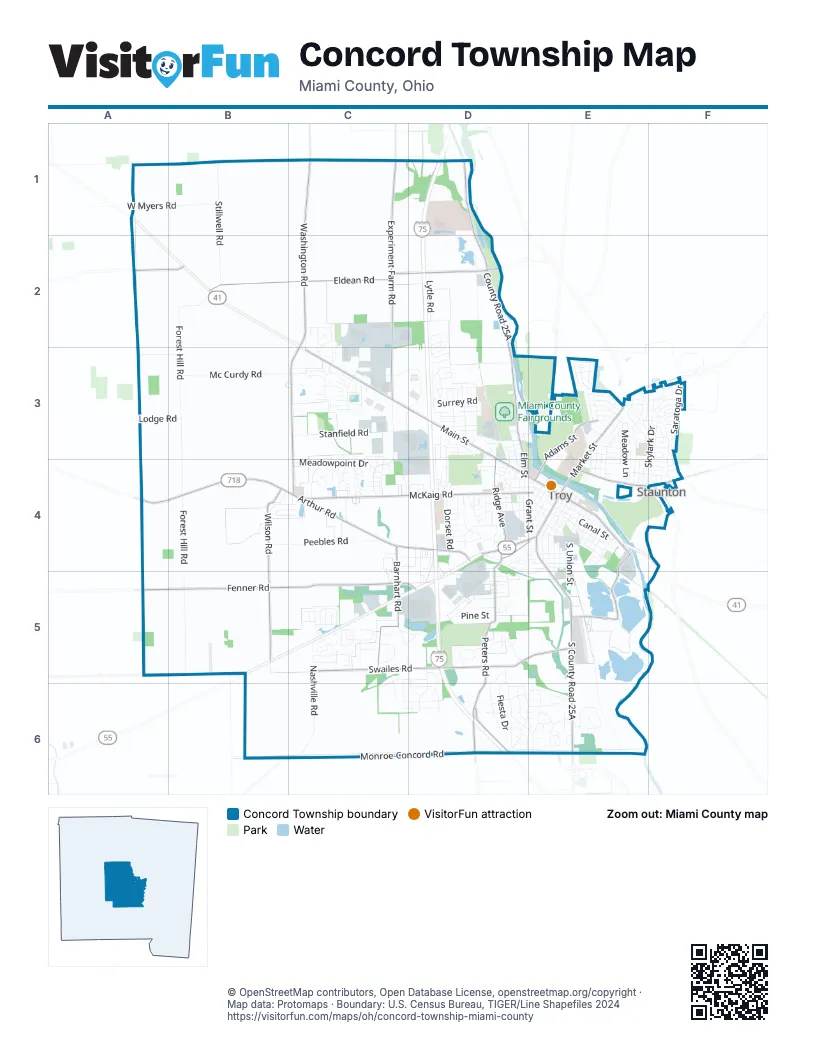
Street index of Concord Township
Each street on the sheet and the grid squares it crosses.
- West Main StreetC3, D3, D4, E4
- East Main StreetE4
- Public SquareE4
- Arthur RoadA4, B4, C4, D4
- County Road 25AD1, D2, D3
- South County Road 25AE5, E6
- South Market StreetE4, E5
- North Market StreetE3, E4
- East Staunton RoadE4, F4
- West Market StreetD4, E4
- North Elm StreetD3, D4
- State Route 202F4
- Washington RoadC1, C2, C3, C4
- Monroe-Concord RoadB6, C6, D6, E6
- Eldean RoadB2, C2, D2
- Fenner RoadA5, B5, C5, D5
- Swailes RoadC5, D5, E5
- Experiment Farm RoadC1, C2, C3
- McKaig RoadC4, D4, E4
- Peters RoadD5, D6
- Wilson RoadB4, B5
- Barnhart RoadC4, C5
- Dye Mill RoadE4, E5
- South Ridge AvenueD3, D4
- Adams StreetE3, E4
- West Horseshoe Bend RoadB5
- Peters AvenueD4, E4, D5
- West Sugar Grove RoadA2, B2
- Troy Urbana RoadE3, F3
- Troy-Sidney RoadE3
- North Forest Hill RoadB2, B3, B4
- South Forest Hill RoadB4, B5
- Stillwell RoadB1, B2
- South Stanfield RoadC3, C4
- South Dorset RoadD3, D4, D5
- Nashville RoadC5, C6
- North Dorset Lytle RoadD2, D3
- Peebles RoadB4, C4
- Mc Curdy RoadB3, C3
- Stonyridge AvenueE3, F3, F4
- Skylark DriveF3, E4, F4
- West Stanfield RoadC3
- Maplecrest DriveE3, E4
- Merrimont DriveD5, D6, E6
- South Union StreetE4, E5
- Meadowpoint DriveC4
- West Myers RoadA1, B1
- Commerce Center BoulevardC3, D3, C4
- South Mulberry StreetE4
- Towne Park DriveC3, D3
- Trade Square WestD3
- South Crawford StreetE4
- Lincolnshire DriveD6, E6
- East Canal StreetE4
- South Walnut StreetE4
- South Clay StreetE4, E5
- North Dorset RoadD3
- Lee RoadF3
- West Race StreetD4, E4
- Saratoga DriveF3
- Summit AvenueD4
- Corporate DriveC2, C3
- Seneca DriveD5, D6
- Fiesta DriveD5, D6
- Washington Concord RoadB1
- Marybill DriveC2, C3
- Drury LaneD4, E4
- Meadow LaneE3, E4
- Shaftsbury RoadE3
- Linwood DriveE3, E4, F4
- Race DriveE4
- East Franklin StreetE4
- Wayne StreetD4
- Windmere DriveD6, E6
- Branford RoadD3
- Riverside DriveE3
- West Water StreetD4, E4
- Brookwood DriveD6, E6
- Countryside Drive NorthE6
- Sedgwick WayC3, C4
- Creekwood DriveD5
- Huntington DriveC5
- Harrison StreetD3, D4
- Boone DriveE6
- Surrey RoadD3
- Executive DriveC3
- West Franklin StreetD4, E4
- Lincoln AvenueD4
- Lytle RoadD2
- Greenbriar DriveC5, D5, C6
- Newcastle DriveC3
- Broken Woods DriveD6, E6
- Pleasant View DriveD5, D6
- Shady Tree DriveC5
- Shenandoah DriveD5, D6
- Grant StreetE4
- Heather RoadD3, D4
- Stonebridge DriveC4
- West Thomas RoadA3, B3
- Archer DriveD5
- Willow Creek WayC3, C4
- South Plum StreetE4
- Cornish RoadD3
- Renwick WayC5
- Fox RunC5
- North RoadD3
- Worthington DriveC5
- Fox Harbor DriveC3
- Lodge RoadA3, B3
- Vincent AvenueD4, E4, D5, E5
- Pine StreetD5
- Fleet RoadD3
- Sussex RoadD3
- Kings Chapel DriveC3
- Laurel Creek DriveC6, D6
- Saint Andrews DriveC3
- Brook Park DriveD2, D3
- North Norwich RoadD3
- Robin Hood LaneE3
- Stephenson DriveE3, F3
- Mayfield DriveE4, F4
- Parkwood DriveC2
- Armand DriveD4
- Greenlawn DriveD6
- Sherwood DriveE3
- Tyrone RoadD3
- Westwood RoadC4, D4
- Westlake DriveC4
- Scott StreetE4
- Covent RoadD3
- Parkview DriveC5
- East Water StreetE4
- West Ross StreetD4, E4
- 4th StreetD3
- Southview DriveD4, E4, D5
- Trade Square EastD3
- Red Maple DriveB4, C4
- Brukner DriveD5
- Waco StreetD5
- Dellwood DriveE3, E4
- Glendale DriveE3, E4
- Walnut Ridge DriveE6
- Mumford DriveD4
- Crestview DriveE3
- Kings Chapel Drive NorthC2, C3
- Cloverdale DriveE3
- Jillane DriveC4, D4
- East West StreetE4
- Garfield AvenueD4
- Crescent DriveD4
- Winchester DriveC5
- Long StreetE4
- Ohio AvenueE3, E4
- Lake StreetD4
- Miami StreetE3
- East Dakota StreetE4
- Hobart Hills RoadD4
- Spruce StreetD5
- Shamrock LaneC3, C4
- Virginia AvenueE3, E4
- South Counts StreetE4
- Brookview RoadE6
- Woodlawn DriveC5, D5
- Finsbury LaneE3
- Merry Robin RoadE3
- West Staunton RoadE3, E4
- Thornhill DriveC3
- Little John RoadE3
- Governors DriveE3
- Penn RoadD4
- Northbridge TrailC5, C6
- Hillcrest DriveD5
- Stony Creek RoadD3
- Michigan AvenueE3, E4
- Lakeshore DriveC5, D5
- Washington Bend CourtC3
- Conwood DriveC5
- West Dakota StreetD4, E4
- Williams StreetE4
- Keller DriveD2, D3
- South Weston RoadD3
- Chelsea RoadD3
- Croydon RoadD3
- Floral AvenueE4
- West Simpson StreetD4, E4
- Morehead StreetE4
- Heatherstone DriveB4, C4
- Oak StreetE4
- Beechwood DriveC5, D5
- Tamworth RoadE3
- Ellis StreetE4
- Woodcreek CourtD6
- Amelia AvenueD4, E4, E5
- Carriage Crossing WayC2, C3
- South Short StreetE4
- Hickory LaneD5
- Elmwood AvenueD4, E4, D5
- Waterbury PlaceD2, D3
- South Cherry StreetE4
- Westhaven DriveC3
- Dartmouth RoadD3
- West Canal StreetE4
- Cobblestone DriveC4
- Dickerson DriveD5
- Frontier DriveF3
- Crossbow LaneE3
- Michael DriveF3
- Fairfield RoadE3
- Fairway DriveD5
- Larkpur DriveB4, C4
- Hilltop DriveF3
- Carrousel DriveE6
- Loxley LaneE3
- Chatham DriveC5
- Young StreetE4
- Locust LaneE4
- Vista Ridge DriveE6
- Forrest LaneE4
- Rockingham DriveC5, C6
- Henley RoadD3
- East Ross StreetE4
- Cara DriveC5
- Indiana AvenueE3, E4
- Greenfield DriveE3
- Troy Town DriveC3, D3
- Premwood DriveD5
- North Madison StreetD3, D4
- Maple StreetD5
- Golden Eagle DriveD4
- Paradise TrailF3
- Racer StreetE4
- Kirk LaneE3
- Edgewater DriveC5
- Stonewood DriveE6
- Wagon Wheel WayC2
- Edinburgh DriveC5
- South Frank StreetE4
- Northbrook LaneE3, F3
- Gettysburg DriveF3
- Hickorywood DriveD6
- South Oxford StreetE4
- Stone Circle DriveE6
- Fernwood DriveE3
- Maplewood DriveE4
- East Simpson StreetE4
- Clarendon RoadD3
- Farnham RoadD3
- Marby DriveD6
- Black Oak DriveC5
- Old Newton PikeD4
- Trade Road EastD3
- Foss WayE3
- PondviewC5
- Beekman DriveD2
- Bristol RoadD3
- Cloverleaf DriveD4
- Kenton WayC5
- Olympic DriveC3
- North Ridge AvenueD3
- South Elm StreetD4
- Dronfield RoadE3
- Brookfield LaneD3
- Longwood DriveF3
- Old Schoolhouse RoadD5
- Windsor RoadD3
- Normandy LaneC5
- Woodstock CourtD5, D6
- Locust View DriveE6
- Pennsylvania AvenueD4
- South Madison StreetD4
- Washington StreetD4
- Troy StreetE3
- Old Staunton RoadF4
- South Norwich RoadD3
- Todd LaneF3
- Glasgow DriveC3
- Hydraulic AvenueD4
- Westridge DriveD4
- Walker StreetE4
- Douglas DriveC3
- Enyeart StreetE4
- Twin Lakes DriveC5
- Paul Revere WayD4
- Red Cedar DriveD4
- Edgewood DriveD5
- Nutmeg Square SouthF4
- North Mystic LaneF3
- Sterling DriveC5
- South Mystic LaneF3
- Amberwood DriveC5
- Nutmeg Square NorthF4
- Cheshire RoadD4
- Garden PlaceD6
- Rosewood DriveE6
- Terry DriveE3, F3
- Oakmont DriveD4
- Horizon West CourtC5
- Jefferson StreetD3
- Atlantic StreetD3
- Fountain StreetD3
Things to do on the Concord Township map
Places on the map
- Abbey Credit Union, Inc.
- Advance Auto Parts
- ALDI
- Archer Park
- Concord Elementary School
- Cookson Elementary
- Covered Bridge Park
- Heywood Elementary
- Hobart Urban Nature Preserve
- Hook Elementary School
- Joe Reardon Skatepark
- Kettering Health Network Troy Hospital
- Lowe's
- Meadow Lake
- Meijer
- Miami County Auto Title
- Miami County Fairgrounds
- Miami County Government Complex
- Miami Shores Golf Course
- North Market Ball Fields
- Paul G. Duke Park
- Riverside Cemetery
- Smith Field Airport
- Treasure Island Park
- Troy
- Troy Christian Local Schools
- Troy City Hall
- Troy Community Park
- Troy High School
- Troy High School and Junior High School
- Troy Low Head Reservoir
- Troy Memorial Stadium
- Troy Ohio BMV
- Troy Post Office
- Troy Sand & Gravel (#345)
- Twin Arch Reserve
- Upper Valley Medical Center
- Waco Air Museum
- Waco Field
- Walmart Supercenter
Next to Concord Township
- Staunton
© OpenStreetMap contributors, Open Database License, openstreetmap.org/copyright · Map data: Protomaps · Boundary: U.S. Census Bureau, TIGER/Line Shapefiles 2024















