

Ohio map
Southwest Ohio map
The sheet's index lists 39 highways; I-75, SR 4 and US 52 cross the most grid squares. Things to do inside the boundary: American Sign Museum, Carillon Historical Park and Cincinnati Art Museum. Also on it: Bellefontaine, Blanchester and Centerville.
Open the map (PDF, US Letter)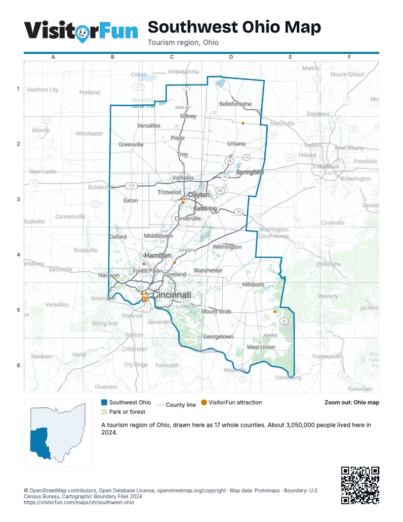
Highway index of Southwest Ohio
Each highway on the sheet and the grid squares it crosses.
- I-70B3, C3, D2, D3
- I-71C4, C5, D3, D4
- I-74B4, B5
- I-75B5, C1, C2, C3, C4, C5
- I-275B4, B5, C4, C5
- I-471C5
- I-675C3, D3
- US 27B4, B5, C5
- US 33D1, E1
- US 35B3, C3, D3
- US 36B2
- US 40D3
- US 42C4, D3, D4
- US 50B5, C5
- US 52B4, B5, C5, D6, E6
- US 62D6
- US 68D2, D3, D6
- US 127B1, B2, B3, B4, C4
- SR 4B4, C3, C4, D2, D3, E2
- SR 32C5, D5, E5
- SR 41D6, E5, E6
- SR 48C4
- SR 49B2, C2, C3
- SR 63C4
- SR 73B4, D4
- SR 122B3
- SR 125C5, D6, E6
- SR 126B4, C4, C5
- SR 129B4, C4
- SR 136D6
- SR 161E2
- SR 235C3
- SR 247E6
- SR 264B5, C5
- SR 334D2
- SR 444C3
- SR 562C5
- SR 732B3
- SR 844C3
Things to do on the Southwest Ohio map
- American Sign Museum
- Carillon Historical Park
- Cincinnati Art Museum
- Cincinnati Museum Center
- Cincinnati Zoo & Botanical Garden
- Cincy Region
- Dayton Aviation Heritage National Historical Park
- Findlay Market
- Jungle Jim's International Market
- Kings Island
- Miami County, OH
- National Museum of the U.S. Air Force
- National Underground Railroad Freedom Center
- Ohio Caverns
- Serpent Mound
Places on the map
- Bellefontaine
- Blanchester
- Centerville
- Cincinnati
- Dayton
- Eaton
- Forest Park
- Georgetown
- Greenville
- Hamilton
- Hillsboro
- Kettering
- Loveland
- Middletown
- Mount Orab
- Oxford
- Piqua
- Sidney
- Springfield
- Trotwood
- Troy
- Urbana
- Vandalia
- Versailles
- West Union
- Wilmington
Next to Southwest Ohio
- East Central Indiana
- Southeast Indiana
- Northern Kentucky
- Central Ohio map
- Northwest Ohio map
- Southeast Ohio map
© OpenStreetMap contributors, Open Database License, openstreetmap.org/copyright · Map data: Protomaps · Boundary: U.S. Census Bureau, Cartographic Boundary Files 2024