

Ohio map
Coshocton map
About 11,114 people live here (Census Bureau, 2024 estimate). The sheet's index lists 196 streets; Cambridge Road, Chestnut Street and South 2nd Street cross the most grid squares. Things to do inside the boundary: Coshocton Hot Air Balloon Festival.
Open the map (PDF, US Letter)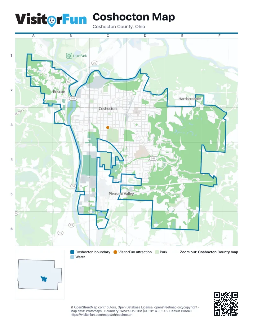
Street index of Coshocton
Each street on the sheet and the grid squares it crosses.
- Caldersburgh StreetA1, A2
- Hill StreetA1, A2, B2
- Hydraulic StreetA1, B1, B2
- Medberry DriveA1
- Retilley DriveA1
- Grace StreetB1, B2
- North Whitewoman StreetB1, B2
- Swayne StreetB1
- High StreetA2, B2
- School StreetA2, B2
- West Chestnut StreetA2, B2
- Bridge StreetB2
- Center StreetB2
- Chestnut StreetB2, C2, D2, E2
- Crestview DriveB2
- Locust StreetB2, C2
- Main StreetB2, C2
- Maple StreetB2
- North 2nd StreetB2
- North 3rd StreetB2, C2
- North Water StreetB2
- North WhitewomanB2
- Roscoe StreetB2
- South 2nd StreetB2, B3, B4, B5
- South 3rd StreetB2, B3
- South Water StreetB2, B3
- South Whitewoman StreetB2, B3
- Sycamore StreetB2, C2
- Walnut StreetB2, B3, C3, D3
- West StreetB2
- 7th StreetC2, C3
- Abbott CourtC2
- Adams StreetC2, D2, D3
- Allen CourtC2
- Burt AvenueC2, C3
- Cemetery StreetC2
- Coe AvenueC2
- East Main StreetC2, D2
- Grandview AvenueC2
- Gross AvenueC2, D2
- Hickory StreetC2, C3
- North 10th StreetC2
- North 11th StreetC2
- North 4th StreetC2
- North 5th StreetC2
- North 6th StreetC2
- North 7th StreetC2
- North 8th StreetC2
- North 9th StreetC2
- Northview StreetC2
- Oak AvenueC2, D2
- Orchard StreetC2, D2
- Park AvenueC2, C3
- South 10th StreetC2, C3
- South 11th StreetC2, C3, C5
- South 4th StreetC2, C3
- South 5th StreetC2, C3
- South 6th StreetC2, C3, C4
- South 8th StreetC2, C3
- 17th StreetD2, D3
- 18th StreetD2, D3
- 19th StreetD2
- 20th StreetD2, E2
- Arthur AvenueD2
- Bedford DriveD2
- Glendale DriveD2, D3
- Grace DriveD2
- Hall DriveD2
- Hay AvenueD2
- Mill StreetD2
- North 12th StreetD2
- North 13th StreetD2
- North 14th StreetD2
- North 15th StreetD2
- North 16th StreetD2
- North 17th StreetD2
- North StreetD2
- Northeast Main StreetD2
- South 12th StreetD2, C3, D3, C4
- South 14th StreetD2, D3, D4
- South 15th StreetD2, D3, D4
- South 16th StreetD2, D3, D4
- Trade AvenueD2
- County Road 16E2, F2, F3
- Elm StreetB3, C3, D3
- Ivy StreetB3, C4, D4
- Kimberly LaneB3
- Mulberry StreetB3, C3
- Pine StreetB3
- River RoadB3
- Spitler DriveB3
- Vine StreetB3, C3, D3
- West Pine StreetB3, C3
- Zero StreetB3
- 5th StreetC3
- Alder StreetC3
- Ash StreetC3
- Bank StreetC3
- Cambridge RoadC3, D3, D4, E4, E5
- Fair StreetC3, C4
- Hamilton AvenueC3
- Hay PlC3
- John StreetC3, C4
- Kenilworth AvenueC3, D3
- Linden AvenueC3
- Lynn StreetC3
- McClain AvenueC3
- Orange StreetC3, D3
- Poplar StreetC3
- South 9th StreetC3
- South Lawn AvenueC3, C4
- Wilson AvenueC3
- 14th StreetD3, D4
- Acorn LaneD3
- Beach AvenueD3
- Boulevard CircleD3
- Concord PlaceD3, D4
- Country Club DriveD3
- Cresent RoadD3
- Fairview BoulevardD3
- Fairway LaneD3
- Green DriveD3
- Highland BoulevardD3
- Hillcrest DriveD3, E3, D4, E4
- Hudson AvenueD3
- Kensington RoadD3, D4
- Mission RidgeD3, D4
- Nicolear AvenueD3
- Oak Pointe DriveD3
- Prospect StreetD3
- Ridgewood DriveD3, E3, E4
- Severn DriveD3, D4
- Sheridan RoadD3, D4
- South 13th StreetD3, C4, D4
- Spring StreetD3
- Sunset DriveD3
- Valley View DriveD3
- Morgan Run RoadF3, E4, F4
- Browns LaneB4, C4
- Arrowhead DriveC4, D4
- Canoe LaneC4, D4
- Cassingham AvenueC4
- Cemetery DriveC4
- Dehart AvenueC4, D4
- Denman AvenueC4, D4
- Fairy Falls DriveC4, D4
- Herbig AvenueC4
- Moccasin LaneC4, D4
- Otsego AvenueC4, C5
- Plum StreetC4
- Serena DriveC4
- Sleepy Hollow DriveC4, D4
- Spruce StreetC4
- Stewart LaneC4, D4
- Tomahawk LaneC4, D4
- Wandle DriveC4
- Bayberry LaneD4, D5
- Betmar DriveD4
- Bow LaneD4
- Buena Vista DriveD4, E4
- Cush LaneD4
- Eagle DriveD4
- East Ivy StreetD4
- Enslee RoadD4
- Evergreen Park DriveD4
- Flint LaneD4
- Fulton DriveD4, E4
- Grant AvenueD4
- Knob Hill DriveD4
- Maple Heights LaneD4
- Marion DriveD4
- Meadowbrook WayD4
- Melbourne RoadD4, E4
- Pareson AvenueD4
- Pleasant Valley DriveD4, C5, D5
- Tuscarawas AvenueD4
- Windermere LaneD4
- Winding DriveD4, D5
- Woodland DriveD4
- AtwoodE4
- Atwood TerraceE4
- Forrest Hill DriveE4
- Overlook DriveE4
- Sharonwood DriveE4
- Skyline HeightsE4
- Township Road 484E4, F4
- Woodcrest LaneE4
- Branch RoadF4, F5
- Township Highway 269F4
- Clow LaneB5, C5
- County Road 271B5, B6
- Cassingham Hollow DriveC5, D5, E5
- Township Road 1260C5
- Hideaway DriveE5
- Sara DriveE5
- Papermill RoadC6
Things to do on the Coshocton map
Places on the map
- Altercare of Coshocton
- Amoco
- Arby's
- Auer Ace Hardware
- Auer Ace Hobbies
- Bancroft Park
- Bargain Shack
- Burt Avenue Wesleyan Church
- Calvary United Methodist Church
- Central Christian Church
- Christian Apostolic Church
- Church of Christ
- Circle K
- Coshocton Antique Mall
- Coshocton Bible Holiness Church
- Coshocton Church of the Nazarene
- Coshocton City Hall
- Coshocton County Courthouse
- Coshocton Elementery School
- Coshocton High School
- Coshocton Ohio 43812
- Coshocton Presbyterian Church
- Coshocton Public Library
- Coshocton Regional Medical Center
- Coshocton Regional Medical Center Heliport
- CVS Pharmacy
- Hall Park
- Johnson-Humrickhouse Museum
- Kids America Inc
- Oak Ridge Cemetery
- Peoples Bank
- Roscoe Cemetery
- Roscoe Rec Ball Park
- South Lawn Cemetery
- Stewart Field
- Story Cannabis Dispensary Coshocton
- Super 8 by Wyndham Coshocton Roscoe Village
- Trinity Episcopal Church
- Triple Locks Theater
Next to Coshocton
- Hardscrabble
© OpenStreetMap contributors, Open Database License, openstreetmap.org/copyright · Map data: Protomaps · Boundary: Who's On First (CC-BY 4.0); U.S. Census Bureau















