

Ohio map
Dover map
About 12,946 people live here (Census Bureau, 2024 estimate). The sheet's index lists 260 streets; North Cross Street, North Wooster Avenue and Race Street cross the most grid squares. Things to do inside the boundary: J.E. Reeves Victorian Home.
Open the map (PDF, US Letter)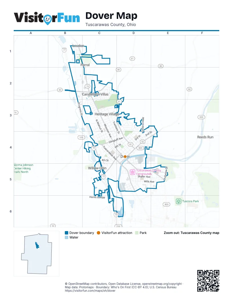
Street index of Dover
Each street on the sheet and the grid squares it crosses.
- Columbia Road NorthwestB1
- Crown Road NorthwestB1
- Crown Street Extended NorthwestB1
- Galaxy Drive NorthwestB1
- Gemini DriveB1
- North Star DriveB1
- Northwest Polaris DriveB1
- Orion DriveB1
- Pegasus DriveB1
- Pheonix DriveB1
- Saint Peters Church Road NorthwestB1, C1
- Saturn DriveB1
- Lake Road NorthwestC1
- Deeds DriveB2, C2
- Guy Smith WayB2, B3
- Progress StreetB2, B3, C3
- Schneiders Crossing Road NorthwestB2
- West Ohio AvenueB2, C2
- Williams Drive NorthwestB2
- 27th StreetC2
- Aspen DriveC2
- Candlelight Lane EastC2, C3
- Candlelight Lane NorthC2
- Candlelight Lane SouthC2
- Deleware DriveC2
- East 27th StreetC2
- East 28th StreetC2
- East 29th StreetC2
- East Ohio AvenueC2
- Jessica DriveC2
- Mohican DriveC2
- North Cross StreetC2, C3, C4, D4
- North Wooster AvenueC2, C3, C4, D4
- Northwood DriveC2
- Oakdale DriveC2, C3
- Pinedale DriveC2
- Poolside LaneC2, D2
- Poolview CircleC2
- Race StreetC2, C3, C4, D4
- Schneiders Crossing Road NortheastC2
- Seneca DriveC2
- Shawnee DriveC2
- South Northwood DriveC2
- Tremont StreetC2, C3, D3, D4
- Waldenmyer DriveC2, C3
- Woodruff Street NorthwestC2
- Wyandot DriveC2
- Young DriveC2
- Crater AvenueD2
- Deis Hill RoadD2
- North Crater AvenueD2, D3, D4
- 19th StreetC3
- Angel DriveC3
- Brookside DriveC3
- Calico DriveC3
- Chestnut StreetC3, C4
- Davis Street NorthwestC3, C4
- Deis LaneC3
- Dover AvenueC3, C4
- East 12th StreetC3, D3, C4
- East 13th StreetC3, D3
- East 14th StreetC3, D3
- East 15th StreetC3
- East 16th StreetC3
- East 17th StreetC3
- East 18th StreetC3
- East 20th StreetC3
- East 21st StreetC3
- Heritage CircleC3
- Howard DriveC3, D3
- Karns DriveC3
- McMillan AvenueC3, D3
- Mr 15287 AlleyC3
- Mr15313 AlleyC3, D3
- North Walnut StreetC3, C4, D4
- Oak StreetC3, C4
- Park Entrance RoadC3
- Stucky DriveC3
- Wade DriveC3
- West 13th StreetC3, C4
- West 14th StreetC3, C4
- West 15th StreetC3
- West 16th StreetC3
- West 17th StreetC3
- West 20th StreetC3
- West 21st StreetC3
- West 22nd StreetC3
- West 23rd StreetC3
- East 11th StreetD3, C4
- East 3rd StreetD3, D4
- Evergreen DriveD3, D4
- Forest Ridge DriveD3
- Gibbs Lane NorthwestD3, D4
- Hawthorn DriveD3
- High StreetD3, D4, E4
- Jennifer DriveD3
- Lilac LaneD3
- Meadowbrook DriveD3
- Park View DriveD3
- Parkdale DriveD3
- Parkview DriveD3
- Schaar DriveD3, E3, E4
- Weinsz DriveD3
- Winkler DriveD3, D4
- East 2nd StreetE3, D4
- Reichman Drive NorthwestE3
- 2nd StreetC4, D4
- Broad StreetC4
- Center StreetC4
- Charles DriveC4, C5
- Cherry StreetC4, D4
- Commercial ParkwayC4
- Depot StreetC4
- East 10th StreetC4, D4
- East 6th StreetC4, D4
- East 8th StreetC4, D4
- East Slingluff AvenueC4, D4
- Elm StreetC4
- Karl AvenueC4
- North Tuscarawas AvenueC4, D4, D5
- North Wooster LaneC4
- Rausch CourtC4
- Reporter CourtC4, D4
- Ross CourtC4, D4
- Schwindt CourtC4, D4
- State Route 39 NorthwestC4
- West 10th StreetC4
- West 11th StreetC4
- West 12th StreetC4
- West 3rd StreetC4, D4, C5
- West 4th StreetC4, D4
- West 5th StreetC4, D4
- West 6th StreetC4
- West 7th StreetC4
- West 8th StreetC4
- West 9th StreetC4
- West Slingluff AvenueC4
- Arch StreetD4
- Bank LaneD4
- Bell AvenueD4
- Betscher AvenueD4
- Buckeye AvenueD4
- Canal RoadD4
- Canal StreetD4
- Chelsea DriveD4, E4
- East 4th StreetD4
- East 5th StreetD4
- East 7th StreetD4
- East AvenueD4
- East Broadway StreetD4
- East Front StreetD4, E4
- Franklin DriveD4
- Glenview AvenueD4
- Hemlock AvenueD4
- Highland AvenueD4
- Lakeview DriveD4, E4
- Lincoln AvenueD4
- Lloyd StreetD4
- Margaret AvenueD4
- North Fairview AvenueD4
- North Johnson AvenueD4
- Park StreetD4, D5
- Pine StreetD4, D5
- Poplar StreetD4
- Regent StreetD4, D5
- Short StreetD4
- South Crater AvenueD4
- South Cross StreetD4
- South Fairview AvenueD4
- South Johnson AvenueD4
- South Johnson StreetD4
- South Lloyd StreetD4
- South Wooster AvenueD4, D5
- Stadium DriveD4
- Sterling AvenueD4
- Sweitzer CircleD4
- West 2nd StreetD4
- West Broadway StreetD4, D5
- West Front StreetD4, D5
- Wooster AvenueD4
- Dover Zoar Road NorthwestE4
- Edgewood DriveE4
- Hillside DriveE4
- Circle Drive NorthwestC5
- Hillcrest Drive NorthwestC5
- Jeremy DriveC5
- North Hill Road NorthwestC5, C6
- Red Hill Road NorthwestC5
- Susan DriveC5
- Timothy DriveC5
- Tracy DriveC5
- 11th Drive NorthwestD5
- 12th Street NorthwestD5
- Boat StreetD5
- Bond StreetD5, E5
- Bowers Avenue NorthwestD5
- East Iron AvenueD5, E5
- East Shafer AvenueD5, E5
- East Wills AvenueD5, E5
- FairlaneD5
- Filmore AvenueD5, E5
- Florence AvenueD5
- Grant StreetD5
- Harger StreetD5
- Howe StreetD5
- James Street NorthwestD5
- Lenora StreetD5
- Liberty StreetD5
- Maiden LaneD5
- Main StreetD5
- Marian StreetD5
- Marsh CourtD5
- Martin StreetD5
- Mill StreetD5
- Mr15389 AlleyD5
- North James StreetD5
- Oxford StreetD5
- Prospect StreetD5
- Race TrackD5
- Rear Main StreetD5
- Rick-Secker StreetD5
- River StreetD5
- Rose CourtD5
- Saint Clair StreetD5
- South AvenueD5
- South James StreetD5
- South Reeves AvenueD5
- South Tuscarawas AvenueD5
- Superior StreetD5
- Township Highway 636D5
- Union AvenueD5
- WallaceD5
- Washington StreetD5
- Water StreetD5
- West Iron AvenueD5
- West Shafer AvenueD5
- West Wills AvenueD5
- 5th Street NorthwestE5
- Anola AvenueE5
- Bellevue DriveE5
- Boulevard StreetE5
- Chauncey Avenue NorthwestE5
- Clubview DriveE5
- Emerson AvenueE5
- Hospital DriveE5
- Kaderly Street NorthwestE5
- Kelly Street NorthwestE5
- Madison AvenueE5
- Monroe AvenueE5
- Monroe Street NorthwestE5
- New Dawn CircleE5
- North Bellevue AvenueE5
- North McKinley AvenueE5
- Oakmont DriveE5
- Perry DriveE5
- Pinehurst DriveE5
- South Bellevue AvenueE5
- South McKinley AvenueE5
- Terrace StreetE5
- Horns Lane NorthwestC6
Things to do on the Dover map
Places on the map
- Arby's
- Baker Florist
- Bob Evans
- Buehler's Fresh Foods Dover
- Carter Lumber
- Comfort Inn
- Country Inn & Suites
- Crater Stadium
- CVS Pharmacy
- Deeds Field
- Discount Drug Mart
- Domino's
- Dover Avenue Elementary School
- Dover City Hall
- Dover City Park
- Dover City Pool
- Dover High School
- Dover Middle School
- Dover Post Office
- Dover Public Library
- East Elementary School
- Flynn's Tire & Auto Service
- Fourth Street Cemetery
- Giant Eagle
- Grinders Above & Beyond
- LifeBridge Community Church
- Maple Grove Cemetery
- McDonald's
- Parkway Honda
- Progress Street
- Public Square
- Race Track
- Saint Josephs Catholic Cemetery
- Shoney's
- Slingluff Park
- South Elementary School
- Subway
- Tuscarawas County Fairgrounds
- Union Hospital
- Valley View Animal Hospital
Next to Dover
- Candlelight Villas
- Loudon
- Parral
- Reeds Run
© OpenStreetMap contributors, Open Database License, openstreetmap.org/copyright · Map data: Protomaps · Boundary: Who's On First (CC-BY 4.0); U.S. Census Bureau















