

Ohio map
Englewood map
About 13,282 people live here (Census Bureau, 2024 estimate). The sheet's index lists 252 streets; National Road, South Main Street and North Main Street cross the most grid squares. Also on it: Englewood Centennial Park, Jack Grossnickle Memorial Park and Miami Valley Hospital North.
Open the map (PDF, US Letter)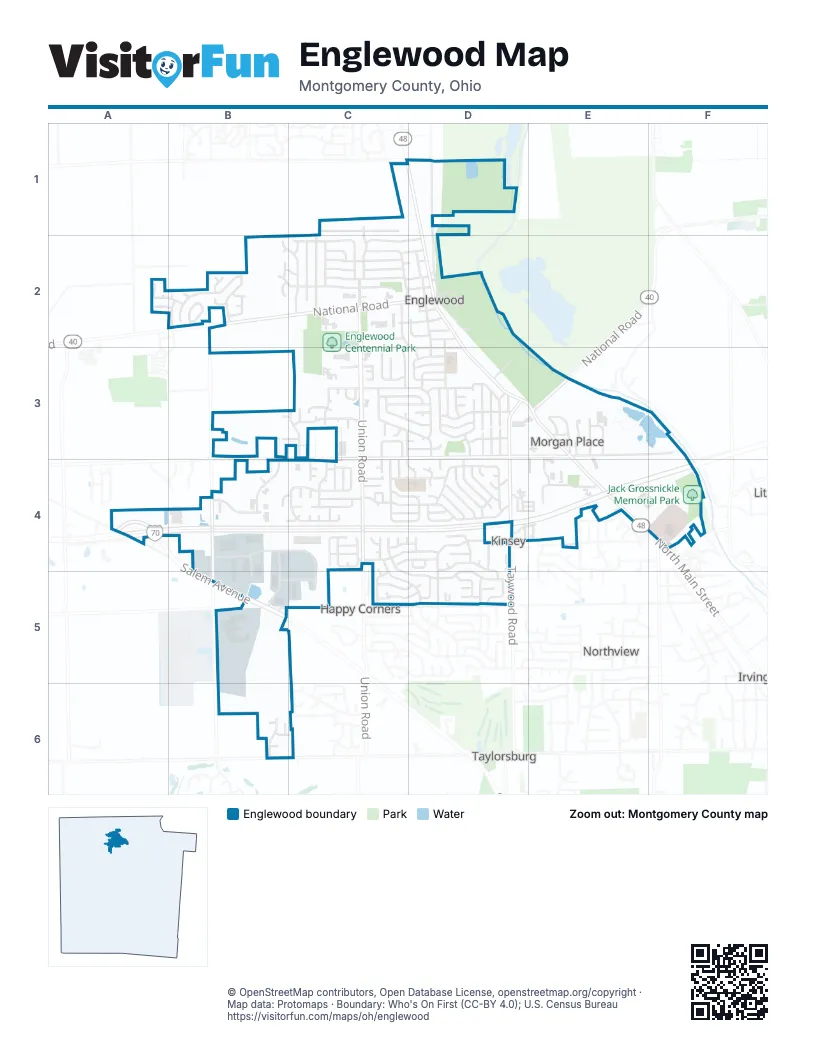
Street index of Englewood
Each street on the sheet and the grid squares it crosses.
- Rankin DriveC1
- Rumson StreetC1, C2
- North Main StreetD1, D2, E4
- River RoadD1
- Valleyview DriveD1, D2
- Haywood CircleA2
- Sagebrush DriveA2, B2
- Sonoma CourtA2, B2
- Beacon LaneB2, C2
- Clearstream WayB2
- Cloverleaf CircleB2
- Heather StreetB2, C2
- Hoke RoadB2, B4, B5
- Lofton DriveB2
- Mares CourtB2
- Mendy CourtB2
- National RoadB2, C2, D2, E3
- Old Carriage DriveB2, C2
- Pleasant ChaseB2
- Pointers RunB2
- Sorna DriveB2
- Thistledown TraceB2
- Twin Lakes CircleB2
- Whisperwood DriveB2
- Windgate CourtB2
- Winding Wheel CourtB2
- Windpointe WayB2
- Winterberry PlaceB2
- Beckenham RoadC2, D2
- Beechgrove DriveC2
- Berkshire CircleC2
- Camborne DriveC2
- Chris DriveC2
- Downing PlaceC2
- Elm CourtC2, D2
- Farrier DriveC2
- Grantham DriveC2
- Herr StreetC2, D2
- Jefferson StreetC2, D2
- Kimmey CourtC2
- Lauricella CourtC2
- Magnolia DriveC2, D2
- Meadowgrove DriveC2
- Overlook StreetC2, D2
- Scott DriveC2
- Tietzman AvenueC2, D2
- Union BoulevardC2, C3
- Westview PlaceC2
- WintersetC2, C3
- Wolf AvenueC2, D2, D3
- Woodmont DriveC2, C3
- Albert StreetD2, D3
- Bensonhurst AvenueD2, D3
- Chestnut StreetD2
- East National RoadD2
- Elm StreetD2
- History LaneD2
- Locust Hill DriveD2, C3
- North Walnut StreetD2
- Orchard AvenueD2
- South Main StreetD2, D3, E3, E4
- South Walnut StreetD2, D3
- Tate AvenueD2
- Bruce CourtB3, C3
- Charlie DriveB3, C3
- Angelia CourtC3
- Avey LaneC3, C4, D4
- Browning AvenueC3, D3
- Chinkapin CircleC3
- Commons AvenueC3, C4
- Deeter DriveC3
- Denwood TrailC3
- Fivepines CourtC3
- Gibralter AvenueC3
- Jillwood DriveC3, C4
- Koerner AvenueC3, D3
- Lambert LaneC3, D3
- Ledford LaneC3, D3
- Mallee CourtC3
- Meadowglen CircleC3
- Miller CourtC3
- Millwood Meadows DriveC3
- Millwood Village DriveC3
- Nies AvenueC3, D3
- Overla BoulevardC3, D3
- Pauly DriveC3
- Rolice CourtC3
- Shady Tree CourtC3
- SnowglenC3
- Snowglen DriveC3
- Timber Mill CourtC3
- Unger AvenueC3, D3
- Union RoadC3, C4
- Village CourtC3
- Wenger RoadC3, C4
- West Wenger RoadC3, D3, E3
- Westerly Hills DriveC3, C4
- Willow Wind CourtC3
- Windflower CircleC3
- Winterset DriveC3
- Allison CourtD3, D4
- Alta AvenueD3
- Arcadia BoulevardD3
- Barkins AvenueD3
- Bluestone AvenueD3
- Bonnycastle AvenueD3
- Brownstone DriveD3
- Eller AvenueD3
- Fallview AvenueD3
- Glenmary AvenueD3
- Hazel AvenueD3, D4
- Hile LaneD3
- Kelly LaneD3
- Lienesch DriveD3
- Little CourtD3
- Lodestone DriveD3
- Mc Graw CourtD3
- Northeast CircleD3
- Oldham WayD3
- Rohr LaneD3
- Silverstone DriveD3
- Sipos CircleD3
- Taywood RoadD3, D4
- Winnimac AvenueD3
- Woodlawn AvenueD3
- Woodside DriveD3
- Ashokan RoadE3
- Brussels AvenueE3
- Caledonia StreetE3
- Dresden DriveE3
- Dublin AvenueE3
- East Wenger RoadE3, F3
- Englewood RoadE3
- Haas DriveE3
- Harrisburg DriveE3
- Hillside CourtE3, E4
- Holiday DriveE3, E4
- Clinton StreetA4
- Bearcreek CourtB4, C4
- Ferrari CourtB4
- Harco DriveB4, B5
- Huls DriveB4
- Lau ParkwayB4, C4, C5
- Smith DriveB4
- Sonora CourtB4, C4
- Alex CourtC4
- Brandon CourtC4
- Buckcreek CourtC4
- Caliente CourtC4, C5
- Campeche CourtC4
- Caprice RoadC4, D4
- Clearwater CourtC4
- Cromer CourtC4
- Crosswinds CourtC4
- Durst DriveC4, D4
- Frampton CourtC4
- Garden Grove WayC4
- Gateway DriveC4, D4
- Gorman AvenueC4, D5
- Greenknob DriveC4
- Greenob DriveC4
- Havenwood DriveC4, D4
- Highland DriveC4, D4
- Kristina Lynn PlaceC4
- Lauren CircleC4
- Meadow Thrush DriveC4
- Meadowrun RoadC4
- Moonlight DriveC4
- Newpark DriveC4
- Northcreek DriveC4
- Northpoint CourtC4
- Park Vista RoadC4, C5, D5
- Pebble CourtC4
- Plover LaneC4
- Porter DriveC4, D4
- Red Wing CourtC4
- Ridge RoadC4
- Rubythroat LaneC4
- Sarah DriveC4
- Southerly Hills DriveC4, D4
- Southview DriveC4
- Sunset DriveC4
- Swallowtail CourtC4
- Terrahill CourtC4
- Vader CourtC4
- Veracruz CourtC4
- Whispering Wind CourtC4
- Wind Haven CourtC4
- Winter Creek CourtC4
- Woodridge DriveC4, D4
- Wren Wood CourtC4
- Wrenwood CourtC4
- Bevan CourtD4
- Brentwood DriveD4
- Brian CourtD4
- Brookwood DriveD4
- Cabot CircleD4
- Candle CourtD4
- Davis CircleD4
- Dedham PlaceD4
- Delta CourtD4
- Derringer DriveD4
- Doris CourtD4
- Forestview CourtD4
- Glenwood CourtD4
- Halfacre AvenueD4
- Heathwood DriveD4
- Katy LaneD4
- Kinsey RoadD4, D5
- Loop DriveD4
- McQuillan DriveD4
- Merrywood DriveD4
- Michele CourtD4
- Parkview AvenueD4
- Pineview DriveD4
- Pleasanton RoadD4, D5
- Rain Tree PlaceD4
- Shelly LaneD4
- Southridge CourtD4
- Taylorsburg RoadD4, E4
- Terracewood DriveD4
- Tradewind CourtD4
- Treherne LaneD4
- Valewood CourtD4
- Hillgrove AvenueE4
- Kimwood DriveE4
- Robinwood CourtE4
- Rockridge RoadE4
- Savina AvenueE4
- Good Samaritan BoulevardF4
- Valryn ParkwayF4
- Cass DriveB5, C5
- Old Salem RoadB5, C5
- Salem AvenueB5
- Cutlass DriveC5, D5
- Dartford RoadC5, D5
- Monte Carlo DriveC5
- Su Casa CircleC5
- Colby WayD5
- Cranlyn DriveD5
- Glenayre DriveD5
- Northglen CourtD5
- Stillmore DriveD5
- Wolcott PlaceD5
- Woodcroft DriveD5
- Wynfield PlaceD5
- Bluebell CourtB6
- Meadowsweet DriveB6
- White Clover CourtB6
- Wildrose LaneB6, C6
- Wintergreen PlaceB6
- East Westbrook RoadC6
Places on the map
- Aldi
- AutoZone
- Bob Evans
- Cafe 19
- Chipotle
- Comfort Inn
- Concord Cemetery
- Days Inn
- Dayton Metro Library
- Domino's
- Earl Heck Community Center
- El Toro Mexican Bar & Grill
- Englewood Animal Hospital
- Englewood Centennial Park
- Englewood City Hall
- Englewood Elementary School
- Englewood Hills Elementary School
- Englewood Hills South Park
- Fairview Cemetery
- Government Park
- Hampton Inn & Suites
- Jack Grossnickle Memorial Park
- Kindred Funeral Home
- Kroger Marketplace
- McDonald's
- Meijer
- Meijer Express
- Miami Valley Hospital North
- Midas
- Motel 6
- Murphy USA
- Oberer Field
- Panera Bread
- Perkins
- Quality Inn
- Randolph Township Historical Society
- Shell
- Skyline Chili
- Speedway
- Walmart Supercenter
Next to Englewood
- Happy Corners
- Irvington
- Kinsey
- Northview
- Taylorsburg
© OpenStreetMap contributors, Open Database License, openstreetmap.org/copyright · Map data: Protomaps · Boundary: Who's On First (CC-BY 4.0); U.S. Census Bureau















