

Ohio map
Fremont map
About 15,814 people live here (Census Bureau, 2024 estimate). The sheet's index lists 295 streets; Bypass Highway, Oak Harbor Road and West State Street cross the most grid squares. Things to do inside the boundary: Rutherford B. Hayes Presidential Library & Museums.
Open the map (PDF, US Letter)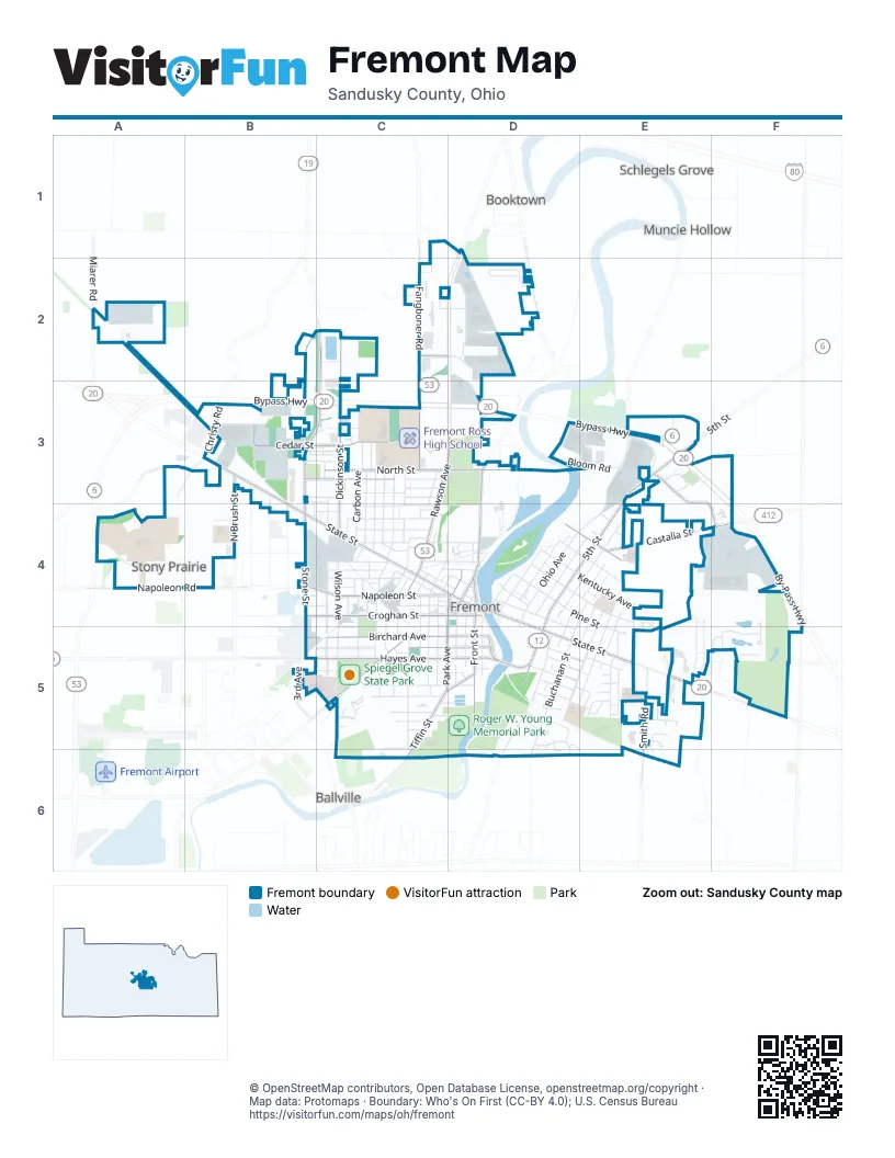
Street index of Fremont
Each street on the sheet and the grid squares it crosses.
- Miarer RoadA2
- Oak Harbor RoadB2, C2, B3, C3, B4
- Paula DriveB2
- Deerfield AvenueC2
- Dickinson StreetC2, C3, C4
- Fangboner RoadC2, D2, C3
- North Oak Harbor HighwayC2, C3
- Sean DriveC2, D2
- Sean StreetC2
- Enterprise DriveD2
- Glenn DriveD2
- Hagerty DriveD2
- Industrial DriveD2
- Port Clinton RoadD2, D3
- Riviera Mobile ManorD2
- Bypass HighwayA3, B3, C3, D3, E3, F3, F4
- Muskellunge Creek RoadA3
- Arlington StreetB3, B4
- Cedar StreetB3, C3, D3
- Christy RoadB3
- Commerce DriveB3
- Durbin DriveB3
- Everett RoadB3
- Gerber RoadB3
- Mill Mobile Home ParkB3
- Moore StreetB3, C3
- North Brush StreetB3, B4
- Oak LaneB3, C3
- Old Oak Harbor RoadB3
- Stevenson StreetB3, C3
- Sugar StreetB3, C3
- West State StreetB3, B4, C4, D4
- White RoadB3, B4
- Youngs Colonial AcresB3, C3
- Ahner StreetC3, C4
- Alger StreetC3, C4
- Ball StreetC3
- Carbon AvenueC3, C4
- Castle RoadC3
- Cleveland NorthC3, C4
- Clinton StreetC3, C4
- ElmhurstC3
- Franklin AvenueC3, C4
- Garfield StreetC3
- Golden Gate EstatesC3
- McKinley StreetC3
- North StreetC3, D3
- Rawson AvenueC3, D3, C4
- Roosevelt StreetC3
- Skyline TerraceC3
- Stilwell AvenueC3, C4
- Vanguard PlaceC3
- Western AvenueC3, C4
- White AvenueC3, C4
- Ball AvenueD3
- Berch TerraceD3
- Bloom RoadD3, E3
- Fremont SpeedwayD3
- Irvington StreetD3
- Johnson StreetD3
- Laurel StreetD3
- North Front StreetD3, D4
- Countryside DriveE3, E4, F4
- Countryside PlaceE3
- Heinz DriveE3
- Majestic DriveE3
- North 5th StreetE3, D4, E4, D5
- North Ohio AvenueE3, D4, E4
- North River RoadE3
- South Bloom RoadE3
- Stine RoadF3
- Napoleon RoadA4
- Spieldenner RoadA4
- Sullivan RoadA4
- Terra WayA4
- Burgoon RoadB4, C4
- Lake StreetB4
- Lime StreetB4
- Napoleon StreetB4, C4, D4
- North Stone StreetB4
- Adams StreetC4
- Austin StreetC4
- Baker StreetC4
- Charles StreetC4
- Cherry StreetC4
- Concord StreetC4
- Court PlaceC4, D4
- Court StreetC4, D4
- Croghan StreetC4, D4
- Dorr StreetC4
- Fenwick StreetC4
- Fulton StreetC4, D4
- Gabel StreetC4
- George StreetC4
- Grandville BoulevardC4, C5
- Grant StreetC4
- Hamlin StreetC4
- HarrisonC4
- Haynes StreetC4, D4
- Hazel StreetC4
- Hickory StreetC4
- JacksonC4
- James StreetC4
- Liberty StreetC4, D4
- LincolnC4, C5
- LocustC4
- Luckey StreetC4
- LynnC4
- Lynn StreetC4
- May StreetC4, D4
- Miller StreetC4
- North Clover StreetC4, D4
- North Granville BoulevardC4
- North Jefferson StreetC4
- North Monroe StreetC4
- North Taft AvenueC4
- North Union PlaceC4
- North Washington StreetC4
- North Wayne StreetC4
- North Wilson AvenueC4
- North Wood StreetC4
- Rawson PlaceC4
- Sheriff StreetC4
- South Clover StreetC4, C5
- South Jefferson StreetC4, C5
- South Monroe StreetC4, C5
- South Taft AvenueC4, B5, C5
- South Washington StreetC4, C5
- South Wayne StreetC4, C5
- South Wilson AvenueC4, C5
- South Wood StreetC4, C5
- Spring StreetC4
- Spruce StreetC4
- St Anns StreetC4
- Stamm StreetC4, D4
- Sycamore StreetC4
- Union PlaceC4
- Wayne PlaceC4
- Wolf AvenueC4
- Woodrow StreetC4
- 2nd StreetD4
- 4th StreetD4, E4
- 6th StreetD4, E4
- Berger PlaceD4
- Bidwell AvenueD4, D5
- Chestnut StreetD4, E4
- East State StreetD4, D5, E5
- Elliot StreetD4
- Fremont TrailD4
- High StreetD4, D5
- Howland StreetD4, D5
- Justice StreetD4
- Kentucky AvenueD4, E4
- Knapp StreetD4
- Middle StreetD4
- Milton StreetD4
- Mulberry StreetD4, E4
- North Arch StreetD4
- North Park AvenueD4
- North Prospect StreetD4, D5
- Ohio TerraceD4
- Park PlaceD4
- Pine StreetD4, E4, E5
- Sand RoadD4
- Sandusky AvenueD4
- South Arch StreetD4, D5
- South Front StreetD4, D5
- South Ohio AvenueD4, D5
- South Park AvenueD4, C5
- Wabash StreetD4
- Walnut StreetD4, E4
- Bark Lane DriveE4
- Bell StreetE4
- Berkshire DriveE4, E5
- Berry CourtE4
- Castalia StreetE4, F4
- Cottage Grove DriveE4
- Cottage StreetE4, E5
- Gibson CourtE4
- Gibson StreetE4
- Herbster StreetE4, E5
- Keller DriveE4
- North 6th StreetE4
- North Buchanan StreetE4, D5
- North Collinwood AvenueE4, E5
- North Columbus AvenueE4, E5
- North Pennsylvania AvenueE4, E5
- Pearl StreetE4
- Woodside LaneE4, E5
- Bark Creek DriveF4
- Barkcreek DriveF4
- By-Pass HighwayF4
- Graham DriveF4
- Greenbriar CircleF4, F5
- 3rd AvenueB5
- Arthur StreetB5, C5
- Hayes AvenueB5, C5, D5
- McKinley ParkwayB5, C5
- McPherson BoulevardB5, C5
- South Stone StreetB5
- Timber LaneB5
- West Birchard AvenueB5
- Autumnwoods DriveC5
- Birchard AvenueC5, D5
- Buckland AvenueC5
- Bush PlaceC5, D5
- Bush StreetC5
- Canfield StreetC5, C6
- Caramel CourtC5
- Cleveland AvenueC5
- Ewing StreetC5, D5
- Garden StreetC5
- Garrison StreetC5, D5
- Home PlaceC5
- June StreetC5
- Kinnear StreetC5
- Loren PlaceC5
- Margene DriveC5
- Memorial ParkwayC5
- Mosser DriveC5
- Pinewood BoulevardC5
- Pinewood DriveC5
- Rice StreetC5
- Rodger Young ParkC5, D5
- Short StreetC5
- South Granville BoulevardC5
- South StreetC5, D5
- Sunset Trailer CourtC5, D5
- Terrace DriveC5
- Tiffin StreetC5, D5, C6
- Tillotson StreetC5
- Twinn StreetC5
- Village StreetC5
- Village WayC5
- Vine StreetC5, D5
- Whittlesey StreetC5
- Wilson AvenueC5
- Allen StreetD5
- Amsden BoulevardD5
- Avis StreetD5
- Birdseye BoulevardD5, E5
- Cardinal DriveD5
- Christy BoulevardD5
- Delaware AcresD5
- Delaware AvenueD5, E5
- Eagle CourtD5, D6
- Elm CourtD5
- ElmwoodD5, E5
- Fisher DriveD5
- Fuller StreetD5
- Harmond StreetD5
- Lilley PlaceD5
- Linden BoulevardD5, E5
- Maike PlaceD5
- Mallard CourtD5, E6
- Marvin BoulevardD5
- Morrison StreetD5, D6
- Nickel StreetD5
- Quail DriveD5, D6
- South 5th StreetD5
- South Buchanan StreetD5, D6
- South Collinwood BoulevardD5, E5
- South Pennsylvania AvenueD5, E5
- South Prospect StreetD5
- Thompson StreetD5
- Willow StreetD5
- Woodland StreetD5
- Carmen PlaceE5
- Circle DriveE5
- Fargo StreetE5
- Finefrock RoadE5
- Fleetwood DriveE5
- Glenwood DriveE5
- Gordon PlaceE5
- Great Lakes VillageE5
- Harding AvenueE5
- Highland CourtE5
- Kaylee DriveE5
- Lawndale DriveE5
- MaplewoodE5
- Mario PlaceE5
- Myah DriveE5
- Oaklawn AvenueE5
- Rosewood StreetE5
- Smith CourtE5
- Smith RoadE5
- South Columbus AvenueE5
- St. Joseph StreetE5
- Sunrise BoulevardE5
- Vargas CourtE5
- Augusta DriveF5
- McPherson HighwayF5
- Pinehurst TrailF5
- St Paul DriveF5
- St Thomas DriveF5
Things to do on the Fremont map
Places on the map
- Aaron's
- Advantage Ford
- ALDI
- Anderson Fields
- Applebee's
- Arby's
- Atkinson Elementary School
- AutoZone
- Besithisa Inc.
- Big Lots
- Birchard Park
- Birchard Public Library
- Bob Evans
- Cantral Fire Station
- Christian and Missionary Alliance Church
- Comfort Inn & Suites
- Countryside Park
- County Home Cemetery
- Croghan Elementary School
- CVS Pharmacy
- Denny's
- Dollar Tree
- East Side Park
- Family Dollar
- Fifth Third Bank
- Fire Station Number 2
- Fremont Country Club
- Fremont Ross High School
- Fremont Speedway
- Memorial Hospital
- Otis Elementary School
- Robert L. Walsh Park
- Roger W. Young Memorial Park
- Rutherford B Hayes Presidential Center Library
- Saint Josephs Cemetery
- Sandusky County Commissioners' Office
- Sandusky County Law Library
- Spiegel Grove State Park
- Walmart Supercenter
Next to Fremont
- Ballville
- Booktown
- Muncie Hollow
- Schlegels Grove
© OpenStreetMap contributors, Open Database License, openstreetmap.org/copyright · Map data: Protomaps · Boundary: Who's On First (CC-BY 4.0); U.S. Census Bureau















