

Ohio map
Northwest Ohio map
The sheet's index lists 43 highways; US 6, I-75 and I-80 cross the most grid squares. Things to do inside the boundary: African Safari Wildlife Park, Armstrong Air & Space Museum and Cameo Pizza. Also on it: Ada, Bellevue and Bluffton.
Open the map (PDF, US Letter)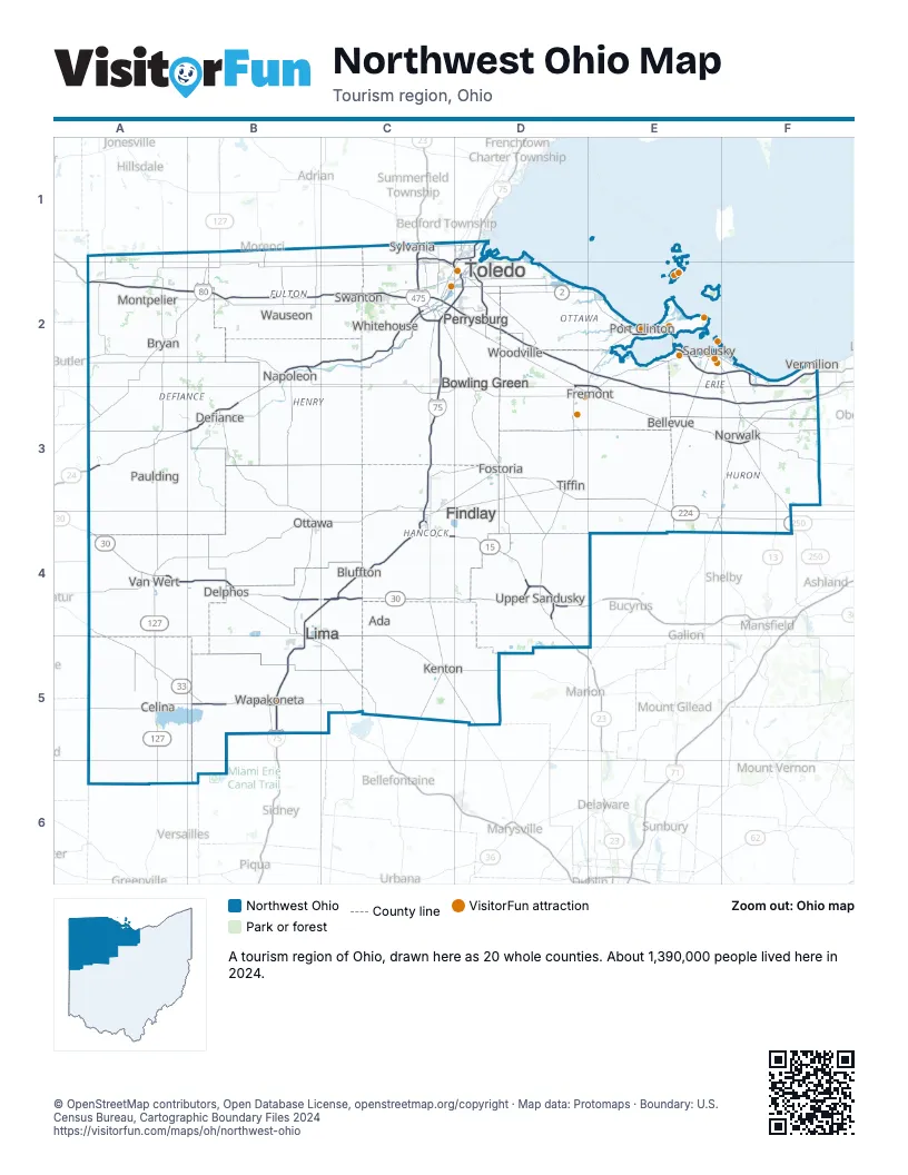
Highway index of Northwest Ohio
Each highway on the sheet and the grid squares it crosses.
- I-75B4, B5, C2, C3, C4, D1, D2
- I-80A2, B2, C2, D2, E2, E3, F3
- I-90A2, B2, C2, D2, E2, E3, F3
- I-280D1, D2
- I-475C1, C2
- US 6A2, B2, C2, C3, D2, D3, E2, E3, F2
- US 20B2, C2, D2, E2, E3, F3
- US 20AB2
- US 23C1, C2, D2, D4, D5
- US 24A3, B2, B3, C2
- US 30A4, B4, C4, D4, E4
- US 33A4, A5, B5, C5
- US 68C4
- US 127A2, A4, A5, A6, B2
- US 223C1
- US 224A4, C3, C4, D3, E3, E4, F4
- US 250F2, F3
- SR 2A2, D2, E2, F2
- SR 12C4
- SR 13F3, F4
- SR 15A2, C3, C4, D4
- SR 18E3, F3
- SR 19D2, E2, E3
- SR 25C2, D2
- SR 29A5, B5
- SR 37C4
- SR 49A4
- SR 53D2, D3, E2
- SR 65B5
- SR 66B2
- SR 67A5
- SR 81A4
- SR 105D2
- SR 113E3, F3
- SR 118A5
- SR 162F3
- SR 197A5
- SR 199D3
- SR 269E2
- SR 420D2
- SR 696C4
- SR 703A5
- SR 707A5
Things to do on the Northwest Ohio map
- African Safari Wildlife Park
- Armstrong Air & Space Museum
- Cameo Pizza
- Cedar Point
- Fast Eddie's Sports Park - Bar & Kitchen
- Ghostly Manor Thrill Center
- Goofy Golf
- Historic Lyme Village
- Jet Express
- Kelleys Island Ferry Boat Line
- Lagoon Deer Park
- Lake Erie Shores & Islands
- Miller Ferry
- North Coast Parasail & Watersports
- Perry's Cave Family Fun Center
- Perry's Victory and International Peace Memorial
- Portage River Paddling Company
- Put-in-Bay Tour Train
- Rutherford B. Hayes Presidential Library & Museums
- Seneca Caverns
- Toledo Museum of Art
- Toledo Zoo & Aquarium
Places on the map
- Ada
- Bellevue
- Bluffton
- Bowling Green
- Bryan
- Celina
- Defiance
- Delphos
- Findlay
- Fostoria
- Fremont
- Kenton
- Lima
- Montpelier
- Napoleon
- Norwalk
- Ottawa
- Paulding
- Perrysburg
- Port Clinton
- Sandusky
- Swanton
- Sylvania
- Tiffin
- Toledo
- Upper Sandusky
- Van Wert
- Vermilion
- Wapakoneta
- Wauseon
- Whitehouse
- Woodville
Next to Northwest Ohio
- East Central Indiana
- Northeast Indiana
- Southeast Lower Peninsula
- Central Ohio map
- Northeast Ohio map
- Southwest Ohio map
© OpenStreetMap contributors, Open Database License, openstreetmap.org/copyright · Map data: Protomaps · Boundary: U.S. Census Bureau, Cartographic Boundary Files 2024