

Ohio road map
I-275 in Ohio map
I-275 is about 54 miles in Ohio. It has 36 exits, from Exit 21 at mile 4 to Exit 72 at mile 53. It meets 19 highways; US 50, US 52 and OH 126 meet it in the most grid squares.
Open the map (PDF, US Letter)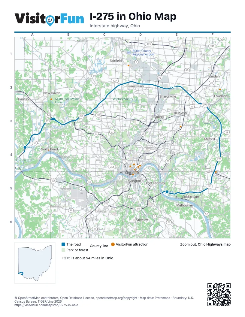
Exits on I-275 in Ohio
Each exit in mile order, with its grid square.
- Exit 21mile 4, A3
- Exit 25mile 6, A3
- Exit 5mile 7, B3
- Exit 7mile 9, B3
- Exit 9mile 10, B3
- Exit 28mile 10, B3
- Exit 31mile 13, C3
- Exit 33mile 15, C2
- Exit 36mile 18, C2
- Exit 39mile 21, D2
- Exit 41mile 23, D2
- Exit 42mile 23, D2
- Exit 42Amile 23, D2
- Exit 42Bmile 24, D2
- Exit 43Amile 25, D2
- Exit 43Bmile 25, D2
- Exit 44mile 26, E2
- Exit 46mile 28, E2
- Exit 47mile 29, E2
- Exit 49mile 30, E2
- Exit 49Amile 30, E2
- Exit 17Amile 30, E2
- Exit 49Bmile 30, E2
- Exit 50mile 31, E2
- Exit 52mile 33, F3
- Exit 54mile 35, F3
- Exit 57mile 38, F3
- Exit 59mile 39, F4
- Exit 59Amile 40, F4
- Exit 59Bmile 40, F4
- Exit 63A/63Bmile 44, F4
- Exit 63A-Bmile 44, F4
- Exit 65mile 47, F5
- Exit 69mile 50, E5
- Exit 71mile 52, E5
- Exit 72mile 53, E5
Highways I-275 meets
Each highway it meets and the grid squares where they meet.
- US 50A4, F4
- I-74B3
- US 52B3, E5
- OH 128B3
- OH 126B3, C2
- US 27C2
- US 127C2
- OH 4D2
- OH 747D2
- I-75D2
- US 42E2
- I-71E2
- US 22E2
- OH 3E2
- OH 28F3
- OH 131F4
- OH 450F4
- OH 32F4
- OH 125F5
Towns along I-275 in Ohio
In mile order, with the grid square of each.
- Shawneemile 0, A4
- Elizabethtownmile 0, A4
- Hoovenmile 3, A3
- Grandviewmile 5, A3
- Blue Jaymile 6, A3
- Miamitownmile 8, B3
- Taylor Creekmile 9, B3
- Dentmile 9, B3
- White Oakmile 12, B3
- Groesbeckmile 13, C3
- Dry Ridgemile 14, C3
- Northgatemile 14, C3
- Northbrookmile 15, C2
- Dunlapmile 15, C2
- Mount Healthy Heightsmile 16, C2
- New Burlingtonmile 17, C2
- Pleasant Runmile 17, C2
- Forest Parkmile 18, C2
- Pleasant Run Farmmile 19, C2
- Fairfieldmile 19, C2
- Springdalemile 21, D2
- Glendalemile 24, D2
- Sharonvillemile 25, D2
- Blue Ashmile 27, E2
- Breconmile 29, E2
- Highpointmile 29, E2
- Montgomerymile 30, E2
- Sixteen Mile Standmile 30, E2
- The Village of Indian Hillmile 32, F2
- Lovelandmile 33, F3
- Miamivillemile 35, F3
- Mulberrymile 37, F3
- Camp Dennisonmile 37, F3
- Milfordmile 38, F3
- Summersidemile 42, F4
- Mount Carmelmile 44, F4
- Withamsvillemile 46, F5
- Cherry Grovemile 46, F5
- Forestvillemile 48, F5
- Coldstreammile 48, F5
- Sherwoodmile 49, F5
- Fruit Hillmile 50, E5
- Salem Heightsmile 50, E5
- Cincinnatimile 53, E5
Things to do on the I-275 in Ohio map
© OpenStreetMap contributors, Open Database License, openstreetmap.org/copyright · Map data: Protomaps · Boundary: U.S. Census Bureau, TIGER/Line 2026