

Ohio road map
I-70 in Ohio map
I-70 is about 222 miles in Ohio. It has 98 exits, from Exit 156B at mile 0 to Exit 225 at mile 221. It meets 59 highways; US 40, I-270 and US 35 meet it in the most grid squares.
Open the map (PDF, US Letter)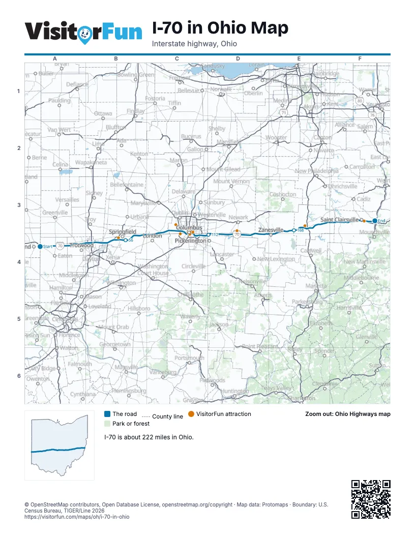
Exits on I-70 in Ohio
Each exit in mile order, with its grid square.
- Exit 156Bmile 0, A4
- Exit 10mile 9, A4
- Exit 14mile 15, A4
- Exit 21mile 21, A4
- Exit 24mile 23, A4
- Exit 26mile 25, A4
- Exit 29mile 29, A4
- Exit 32mile 32, B4
- Exit 33Amile 33, B4
- Exit 33Bmile 33, B4
- Exit 33mile 34, B4
- Exit 36mile 37, B4
- Exit 38mile 39, B4
- Exit 41mile 41, B4
- Exit 26Amile 44, B4
- Exit 26Bmile 44, B4
- Exit 44mile 44, B4
- Exit 47mile 46, B4
- Exit 48mile 48, B4
- Exit 52Amile 51, B4
- Exit 5Amile 52, B4
- Exit 5Bmile 52, B4
- Exit 52Bmile 52, B4
- Exit 54mile 54, B4
- Exit 59mile 59, B4
- Exit 62mile 62, B4
- Exit 66mile 65, B4
- Exit 72mile 71, C4
- Exit 79mile 78, C3
- Exit 80mile 80, C3
- Exit 85mile 84, C3
- Exit 91mile 90, C3
- Exit 91Amile 91, C3
- Exit 91Bmile 91, C3
- Exit 93mile 93, C3
- Exit 94mile 93, C3
- Exit 95mile 94, C3
- Exit 96mile 95, C3
- Exit 97mile 96, C3
- Exit 98Bmile 97, C4
- Exit 1A, West Rich Streetmile 98, C4
- Exit 99B-Cmile 98, C4
- Exit 100Bmile 99, C4
- Exit 101Bmile 99, C4
- Exit 101Amile 100, C3
- Exit 102mile 101, C4
- Exit 103 Bmile 102, C4
- Exit 103mile 102, C4
- Exit 105 Amile 104, C4
- Exit 105Bmile 104, C4
- Exit 107Amile 106, C4
- Exit 107Bmile 106, C4
- Exit 107mile 106, C4
- Exit 108mile 107, C4
- Exit 110Amile 108, C4
- Exit 110Bmile 108, C4
- Exit 110mile 109, C4
- Exit 112Amile 110, C4
- Exit 112Bmile 111, C4
- Exit 112mile 111, C4
- Exit 112Cmile 111, C4
- Exit 118mile 117, D4
- Exit 122mile 121, D4
- Exit 126mile 125, D4
- Exit 129mile 127, D4
- Exit 132mile 131, D4
- Exit 141mile 139, D4
- Exit 142mile 141, D4
- Exit 152mile 150, D4
- Exit 153mile 152, E4
- Exit 153Amile 152, E4
- Exit 153Bmile 152, E4
- Exit 154mile 153, E4
- Exit 155mile 153, E4
- Exit 157mile 155, E4
- Exit 160mile 159, E3
- Exit 164mile 162, E3
- Exit 169mile 167, E3
- Exit 176mile 174, E3
- Exit 178mile 176, E3
- Exit 180Amile 177, E3
- Exit 44Amile 177, E3
- Exit 44Bmile 177, E3
- Exit 180Bmile 178, E3
- Exit 186mile 184, E3
- Exit 193mile 191, E3
- Exit 198mile 196, F3
- Exit 202mile 199, F3
- Exit 204mile 202, F3
- Exit 208mile 205, F3
- Exit 213mile 209, F3
- Exit 215mile 212, F3
- Exit 216mile 213, F3
- Exit 218mile 215, F3
- Exit 219mile 216, F3
- Exit 1mile 216, F3
- Exit 220mile 217, F3
- Exit 225mile 221, F3
Highways I-70 meets
Each highway it meets and the grid squares where they meet.
- US 35A4
- OH 320A4
- OH 726A4
- US 127A4
- OH 503A4
- OH 49A4
- OH 48A4
- I-75B4
- OH 202B4
- OH 201B4
- OH 4B4
- OH 235B4
- I-675B4
- US 68B4
- OH 72B4
- OH 41B4
- US 40B4, C3, D4, E3, E4, F3
- OH 54B4
- OH 56C4
- OH 38C4
- US 42C3
- OH 29C3
- OH 142C3
- I-270C3, C4
- I-670C3
- US 62C4
- OH 3C4
- I-71C4
- OH 315C4
- US 33C4
- US 23C4
- OH 317C4
- OH 256C4
- OH 310D4
- OH 158D4
- OH 37D4
- OH 79D4
- OH 13D4
- OH 668D4
- OH 60E4
- OH 146E4
- OH 666E4
- OH 93E4
- OH 797E3
- US 22E3
- OH 83E3
- OH 723E3
- OH 209E3
- I-77E3
- OH 265E3
- OH 285E3
- OH 513E3
- OH 800F3
- OH 149F3
- OH 331F3
- OH 9F3
- I-470F3
- US 250F3
- OH 7F3
Towns along I-70 in Ohio
In mile order, with the grid square of each.
- Lewisburgmile 14, A4
- Brookvillemile 20, A4
- Claytonmile 24, A4
- Englewoodmile 26, A4
- Vandaliamile 30, B4
- Daytonmile 34, B4
- Huber Heightsmile 35, B4
- Park Laynemile 41, B4
- Crystal Lakesmile 42, B4
- Medwaymile 43, B4
- Holiday Valleymile 45, B4
- Green Meadowsmile 46, B4
- Enonmile 47, B4
- Springfieldmile 52, B4
- South Viennamile 66, B4
- Choctaw Lakemile 72, C4
- Lafayettemile 76, C4
- West Jeffersonmile 78, C3
- Lake Darbymile 85, C3
- Columbusmile 89, C3
- Lincoln Villagemile 91, C3
- Marble Cliffmile 95, C3
- Grandview Heightsmile 95, C3
- Bexleymile 102, C4
- Reynoldsburgmile 108, C4
- Bricemile 108, C4
- Pickeringtonmile 111, C4
- Kirkersvillemile 121, D4
- Hebronmile 126, D4
- Buckeye Lakemile 126, D4
- Harbor Hillsmile 128, D4
- Jacksontownmile 130, D4
- Brownsvillemile 139, D4
- Zanesvillemile 151, D4
- Pleasant Grovemile 154, E4
- New Concordmile 167, E3
- Cambridgemile 174, E3
- Byesvillemile 177, E3
- Old Washingtonmile 184, E3
- Fairviewmile 195, F3
- Lloydsvillemile 208, F3
- St. Clairsvillemile 213, F3
- Neffsmile 217, F3
- Blainemile 218, F3
- Lansingmile 219, F3
- Wolfhurstmile 220, F3
- Brooksidemile 221, F3
- Bridgeportmile 221, F3
- Martins Ferrymile 222, F3
Things to do on the I-70 in Ohio map
© OpenStreetMap contributors, Open Database License, openstreetmap.org/copyright · Map data: Protomaps · Boundary: U.S. Census Bureau, TIGER/Line 2026