

Ohio map
Kent map
About 27,720 people live here (Census Bureau, 2024 estimate). The sheet's index lists 300 streets; East Summit Street, Cherry Street and Mogadore Road cross the most grid squares. Things to do inside the boundary: Portage County, OH.
Open the map (PDF, US Letter)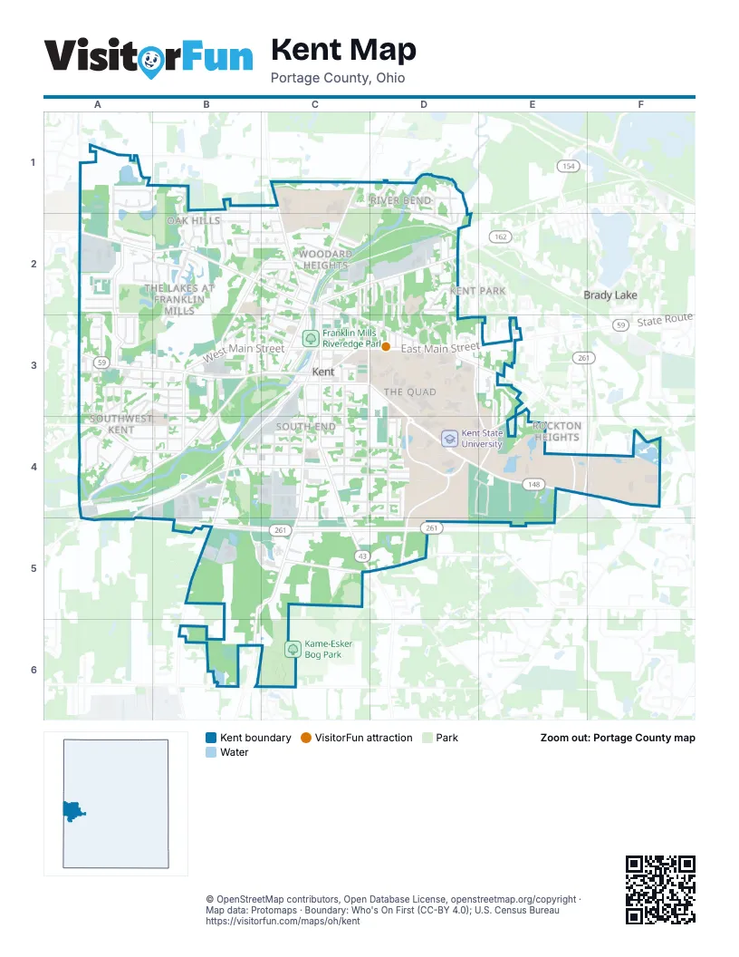
Street index of Kent
Each street on the sheet and the grid squares it crosses.
- South Water StreetC3, C4, C5
- West Main StreetA3, B3, C3
- East Main StreetC3, D3, E3
- Haymaker ParkwayB3, C3
- North Mantua StreetC1, C2, C3
- Gougler AvenueC2, C3
- River StreetC3
- South Mantua StreetC3
- East Summit StreetC3, D3, D4, E4
- Fairchild AvenueA2, B2, C2
- South Lincoln StreetC3, C4, C5
- Summit RoadE4, F4
- North Water StreetC2, C3
- Middlebury RoadB3, A4, B4
- Cherry StreetA4, B4, C4, A5
- Mogadore RoadC3, B4, C4, B5
- Franklin AvenueC3, C4, C5
- Lake StreetC2, D2
- Meloy RoadC5, D5
- Sunnybrook RoadB5, C5, B6
- Hudson RoadC1, C2
- Loop RoadD3, E3, D4, E4
- Campus Center DriveD4, D5
- Silver Meadows BoulevardA2, A3
- Munroe Falls Kent RoadA4, B4
- Horning RoadD3, E3, E4
- Majors LaneB2, C2, B3
- Campus Center Drive WestD4
- Howe RoadB6, C6
- Longmere DriveB3, B4
- Newcomer RoadA1
- Spaulding DriveA3
- Rhodes RoadE3, E4
- Campus Center Drive EastD4
- West Summit StreetC3
- Longcoy AvenueC2
- 6th AvenueE3
- Bryce WayB3
- Stonewater DriveB2, B3
- River Bend BoulevardC1, D1, D2
- Morris RoadD3, D4, D5
- Crain AvenueC2, C3, D3
- Stow StreetB3, C3
- Vine StreetC3, C4
- Overlook DriveD2, D3
- Windward LaneA1
- East School StreetC4, D4
- Elno AvenueA4, B4
- Norwood StreetA3, B3, A4
- South Depeyster StreetC3, C4
- Midway DriveD3
- Jessie AvenueA4, B4
- Admore DriveB2
- Adrian AvenueB1, B2
- Sunset Way BoulevardA1, A2
- Leonard BoulevardA3, B3
- Erin DriveB2
- North Willow StreetC2, C3
- Park AvenueB3, C3
- Roosevelt StreetB3, B4
- Terrace DriveD3
- Harris StreetB4, C4
- Bowman DriveC4, D4
- West Elm StreetB4, C4
- South Willow StreetC3, C4
- Marilyn StreetA4
- South Francis StreetA3, A4
- Cuyahoga StreetB2, C2
- Beryl DriveC4, D4
- Rellim DriveC4, D4
- Allerton StreetD4
- Dodge StreetB4, C4
- Irma AvenueA3
- Petrarca DriveD3, D4
- Valleyview DriveC4, D4
- Johnston DriveD4, E4
- St Clair AvenueC4, C5
- McKinney BoulevardB1, C1
- Stinaff StreetB2, C2
- Miller AvenueD2, D3
- Ivan DriveC4, D4
- Tallmadge AvenueB3, B4
- Walnut StreetC4
- Hilltop DriveC3, D3
- Akron BoulevardA4
- Hickory Mills CircleE4
- Oakwood DriveD2, D3
- Overholt RoadB4
- Verona AvenueB1, B2
- Kevin DriveB1, B2
- Johnson RoadA1
- Chelton DriveA3
- Sunrise DriveA3
- Elizabeth CourtD1, D2
- Gardenview StreetB3
- Athena DriveD4, E4
- Fieldstone DriveA2, B2
- Whitehall BoulevardE4
- Roy Marsh DriveA2, B2
- Stratford DriveE4, E5
- Hampton RoadA3, B3
- Harvey StreetD2, D3
- Hodgeman LaneF4
- North Depeyster StreetC2, C3
- Allen DriveB2, C2
- Eastway DriveD3, E3, D4, E4
- Cedar StreetB4
- Shaw DriveB5, C5
- Whetstone DriveB2, C2
- Pioneer AvenueB3, C3
- Columbus StreetC3
- Chiarucci DriveD3
- Mae StreetD4
- Emich DriveA4
- Needham AvenueC2
- Denise DriveA2
- West Oak StreetC4
- River Edge DriveD1
- Carthage AvenueC2
- Woodard AvenueC2, C3
- Yacavona StreetA4
- North Chestnut StreetC2, B3
- Robert DriveB2, C2
- West Grant StreetC2
- East Oak StreetC4, D4
- Wilson AvenueD3
- Janik DriveD3
- Manchester StreetB3, B4
- Dansel AvenueD2, D3
- Olympus DriveD4, E4
- Pine StreetC4
- Bryce RoadB3
- Rockwell StreetC2
- Dale DriveD3, E3
- Ted Boyd DriveD4
- Marvin StreetC2
- Theatre DriveD3
- Shady Lake DriveA2
- Carol DriveA2
- Martinel DriveC4
- Burnett RoadE4
- Elmwood DriveD3
- Edgewood DriveC2
- South Chestnut StreetB3
- Fairview DriveD3
- Earl AvenueC3
- Glad BoulevardE3, E4
- River Trail DriveD1
- Ada StreetB4
- East College AvenueC3
- Chadwick DriveD4
- Eton RoadA3
- Suzanne DriveA3
- North Lincoln StreetC3
- North Prospect StreetB3
- Whittier DriveC2, B3
- Beech DriveA3, A4
- Hollister DriveA2, B2
- South Prospect StreetB3
- East Elm StreetC4
- East Hall StreetC3
- East Williams StreetC3
- Standing Rock DriveC2
- Brentwood DriveA3
- Meredith StreetB3
- Enterprise WayB4
- Wolcott AvenueC2
- Ernlee DriveA3
- Currie Hall ParkwayC5
- Randall DriveC2
- South Pearl StreetC3
- Woodhill DriveD3
- Woodside DriveD2
- Davey AvenueD2
- East Erie StreetC3
- Cottage Gate DriveB2
- Golden Oaks DriveE3
- Dominion DriveD1
- Brady StreetC3
- Fraternity DriveD4
- Garth DriveA3
- Loblolly CourtE3
- Lawrence DriveA2
- Highland AvenueC3
- Graham AvenueD2
- Indian Valley DriveC5
- University DriveD3
- Grove AvenueB3
- Leebrick DriveD3
- Shawnee DriveC5
- Orchard StreetC2
- Avondale StreetD4
- Anita DriveA2
- Jackson DriveD3
- Garrett StreetA3
- Doramor StreetD2
- Meadow DriveA4
- West Williams StreetC3
- Senhauser DriveD3
- Mason AvenueD2
- Frances DriveD3
- Anita CourtA2
- Cambridge DriveE4
- Laurel DriveA3
- Parmalee StreetA3
- Judith StreetB3
- Beechwold DriveD1, D2
- Dean CourtA2
- Evergreen DriveA3
- High StreetC3
- Sherman StreetD3
- Janet DriveB4
- River Park DriveC1
- Boel DriveA4, A5
- Summit Gardens BoulevardE4
- Lock StreetC2
- Highridge LaneB2
- Hughey DriveA4, B4
- Steele StreetD2
- West School StreetC4
- Burr Oak DriveD3
- Comanche PlaceC5
- Gale DriveA3
- Paulus DriveB4
- Prentice DriveD3
- Edgewater CircleB2
- Rose CourtA2
- Linden RoadD3
- Berkeley StreetD4
- Gatun StreetC2, D2
- Starr AvenueC2
- Louise StreetA3
- Rustic KnollD1
- Benjamin CourtC4, C5
- Alley No 1C2
- Bowman CircleD3
- North Pearl StreetC3
- Maple StreetC4
- North Francis StreetA3
- Statesman PlaceC4, C5
- Gemini CourtE4
- Overbrook DriveA3
- Tonkin CourtC3
- Pleasant AvenueC2
- Aspen CourtE3
- Virginia AvenueD2
- Lower DriveA4
- West Hall StreetC3
- Delone DriveB2
- Adamle DriveB2
- Cindy CircleD1, D2
- Perry StreetD2
- Pisces DriveE4
- Bruce DriveB2
- Forest DriveB3
- Quay BoulevardA2
- Lester A. Lefton EsplanadeE4
- Vfw ParkwayB3
- Anna StreetD2
- Harold StreetC2
- East Grant StreetC2
- East Day StreetC3
- Locke LaneC3
- Burbick WayC3
- Portage StreetC3
- Fleeter CourtC4
- Choctaw PlaceC5
- Delores AvenueC2
- Mohican PlaceC5
- Spruce CourtA2
- Artemis DriveD4, E4
- Sheri DriveA3
- Burns CourtC2
- Marigold LaneC4
- Bart LaneA2
- Walter StreetD2
- Short StreetB3
- Chippewa PlaceC5
- Cunningham DriveD3
- Michaels DriveB2
- Health Center DriveD3, D4
- 1st AvenueD2
- Risman DriveD3, D4
- Lowell DriveB2, B3
- Carlisle CourtA2
- Joseph CourtA2
- Phillip DriveB2
- Stein CourtA2
- West College AvenueC3
- Nicholas DriveB1
- Devon PlaceC5
- Easlan CourtE3
- Aries CourtE4
- Clarkview CircleC2
- Nottingham CircleC2
- Rollins CircleB2
- Luther AvenueD3
- Colleen DriveA3
- Rustic BridgeD1
- Mohawk PlaceC5
Things to do on the Kent map
Places on the map
- Al Lease Park
- Albert J. Flogge Performing Arts Collection
- Blanket Hill
- C Campus Center West
- C/S-32 Ice Arena
- Campus Center East
- Centennial Field
- City of Kent Yard Waste Site
- Davey Elementary School
- Dix Stadium
- Dix Stadium East
- Dix Stadium West
- Fairchild Athletic Fields
- Forest Lake Wildlife Preserve
- Franklin Mills Riveredge Park
- Fred Fuller Park
- Graphic Novels & Comics Collection
- Harbourt/Van Campen/Heer
- Honors College Library
- Jessie Smith Wildlife Preserve
- Joseph F. Morbito Architecture Library
- Juvenile
- Kame-Esker Bog Park
- Kent State Commons
- Kent State University
- Kent State University Special Collections and Archives
- Klaben Ford-Lincoln
- Longcoy Elementary School
- Mail Services
- Map Library
- Maple Brook at Golden Pond
- Marantz Picturebook Collection
- Murray Powers Reading Room
- Nash Hill
- Performing Arts Library
- Plum Creek Park
- Raup Library
- Reinberger Children's Library Center
- Shelly Materials, Inc
- Standing Rock Cemetery
Next to Kent
- Brady Lake
- Eagle Greens
- Kent Park
- Rockton Heights
© OpenStreetMap contributors, Open Database License, openstreetmap.org/copyright · Map data: Protomaps · Boundary: Who's On First (CC-BY 4.0); U.S. Census Bureau















