

Ohio map
Lancaster map
About 41,671 people live here (Census Bureau, 2024 estimate). The sheet's index lists 300 streets; West Fair Avenue, North Columbus Street and Pleasantville Road cross the most grid squares. Also on it: Lancaster Transfer Station, Ety Pointe Center and Fairfield County Fairgrounds.
Open the map (PDF, US Letter)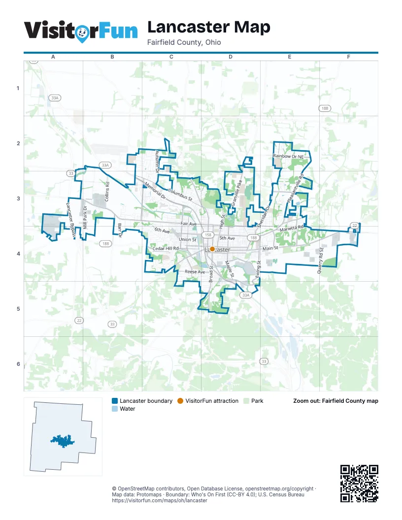
Street index of Lancaster
Each street on the sheet and the grid squares it crosses.
- Lancaster BypassA3, A4
- North Memorial DriveB3, C3, D4
- East Main StreetD4, E4, F4
- South Memorial DriveD4, D5
- North High StreetD3, D4
- Granville PikeD3
- West Main StreetC4, D4
- Lincoln AvenueC4, D4
- Cincinnati-Zanesville Road SouthwestC4
- Lancaster-Newark Road NortheastD2, D3
- Logan-Lancaster RoadD5
- Columbus-Lancaster Road NorthwestB3
- West Fair AvenueA3, B3, C3, D3
- North Columbus StreetB3, C3, D3, D4
- Pleasantville RoadE2, E3, D4, E4
- Sheridan DriveE2, D3, E3, D4
- South Broad StreetD4, D5
- East Fair AvenueD3, E3, D4, E4
- Cedar Hill RoadC4
- Baltimore Road NorthwestC3, D3
- Lancaster New Lexington Road NortheastF4
- North Cherry StreetD4
- Lancaster Thornville Road NortheastE2
- Lancaster-Kirkersville Road NorthwestC3
- Lancaster-Circleville RoadC4
- West 6th AvenueC3, C4, D4
- East Chestnut StreetD4, E4
- Rainbow Drive NortheastE2
- East 6th AvenueD4
- East Wheeling StreetD4, E4
- Ety Road NorthwestB3, C3
- Marietta RoadE4, F4
- Lawrence StreetD4
- Harrison AvenueC3, C4
- South Ewing StreetD4
- South Columbus StreetD4
- North Pierce AvenueC3, C4
- Reese AvenueC4, D4
- South Maple StreetD4
- Sugar Grove RoadD4, D5
- North Broad StreetD3, D4
- West Wheeling StreetC4, D4
- Becks Knob RoadB3, B4
- Sells RoadE3, E4
- West Chestnut StreetC4, D4
- North Maple StreetD4
- Wheeling RoadE3
- Tiki LaneE3
- Talmadge AvenueC4
- Kanawha RoadE4
- Wilson Road NorthwestA3, B3
- Canal StreetD4
- Pierce AvenueC3
- North Ewing StreetD4, E4
- Hamburg Road SouthwestC5, D5
- Election House Road NorthwestB2
- Sugar Grove Road SoutheastD4, D5
- Ford StreetD4, D5
- Rainbow Drive NorthwestC2
- B.I.S. RoadD5
- Wheeling Road NortheastE3
- Old Logan Road SoutheastD5
- South Pierce AvenueC4
- West Mulberry StreetC4, D4
- CanalC4, D4, E4
- BankC4, D4, E4
- ZaneC4, D4, E4
- East Allen StreetD4, E4
- CarpenterD4, E4
- Union StreetC4, D4
- Autumn DriveC2, C3
- 6th NorthC4, D4
- 5th NorthC4, D4
- NorthC4, D4
- East Mulberry StreetD4, E4
- Mill Park DriveB3, A4, B4
- East Walnut StreetD4, E4
- Fair NorthC3, D3
- East 5th AvenueD4
- King StreetD4
- Camp Ground Road NorthwestB2, B3
- VineD4
- Frederick StreetD4, E4
- Arbor Valley DriveD3, D4
- Collins RoadB3
- River Valley BoulevardC3
- West 5th AvenueC4, D4
- CenterD4, D5
- Lynwood LaneE4
- Beacon StreetC3
- Harrison WestC3, C4
- Spring StreetC4, D4
- Washington AvenueC3, C4
- Goodwin WestC3, C4
- Broad E 1D3, D4, D5
- Washington WestC3, C4
- Quarry Road SoutheastF4
- Forest Rose AvenueD3, D4
- Garfield AvenueC3, C4
- Boving RoadC4, C5
- Madison AvenueD3, D4
- Lynn DriveE3
- Allen NorthD4
- Independence BoulevardE2
- East Locust StreetD4
- River Valley Circle SouthC3
- PioneerC3, C4
- 8th AvenueC3, C4
- Lanreco BoulevardD4, E4
- Slocum StreetC3, C4
- North Mount Pleasant AvenueD4
- Garfield WestC3, C4
- West Hubert AvenueC4, D4
- Stringtown Road NortheastD3
- Lewis SouthC4, D4
- Reese SouthC4, D4
- Little Brook DriveD5
- Plum NorthD3, D4
- High EastD3, D4
- North Ohio AvenueC3, C4
- Zimmer StreetC3
- North Eastwood AvenueD4
- West 7th AvenueC4
- High WestD4
- Maywood AvenueD3, D4
- Lake NorthD3, D4
- Wacker DriveC3
- Nolder DriveB3, B4
- Bainters CircleD3
- Bent Creek DriveE3
- Williamsburg LaneC4
- Goodwin AvenueC3, C4
- Commerce StreetE4, F4
- Hunter AvenueC4
- Shasta DriveC3, C4
- Walnut SouthC4, D4, E4
- Arnold AvenueD4
- Edgewood AvenueC3, D3
- Maud AvenueC4
- Trace DriveC4
- Stump Hollow Road SoutheastD5
- Lenwood DriveC4
- Oakwood AvenueD4
- Madison EastD3, D4
- Lewis AvenueC4, D4
- Eastwood EastD4
- Pleasant View DriveE3
- Stone Run CourtD3
- West Walnut StreetC4, D4
- Maple EastD4
- South High StreetD4
- Riverway DriveC3
- Barr DriveB3, B4
- Mohawk DriveC4
- BovingD3, D4
- Baldwin DriveE4
- Duffy Road SoutheastE4
- Lake StreetD4
- Elizabeth DriveC4
- Greencrest WayC2, C3
- North Shoshone DriveC3, C4
- McClain BoulevardE3, E4
- Long Bow AvenueC2
- Liberty DriveB3
- Ridgemere WayC4
- Lambton CircleB3, B4
- Coventry CircleC4
- Schwilk Road SoutheastF4
- Courtship DriveE3
- Wesley WayE3
- 2nd StreetC3, D4, D5
- Skyline DriveC3, D3
- Graf StreetC3
- Kemper AvenueE4
- Goslin RoadD4
- Bellmeadow DriveC3
- Shoshone DriveC4
- Mithoff DriveC4
- Whiley AvenueD4
- Boyd StreetD4
- Meadows DriveE3
- Brumfield RoadC4
- Tecumseh DriveC2, C3
- Fairlane Drive NortheastD3, E3
- Eagle AvenueC4, D4
- Cloverdale DriveC2, C3
- Graylock StreetC3
- James RoadE3, E4
- William T CircleD2
- Mount Ida AvenueD5
- Cross Creek AvenueB2, C2
- Early Spring DriveC2, C3
- Cleveland AvenueC4, D4
- Running Brook AvenueC2
- Front StreetC3, D4
- Quail Meadow DriveC2, C3
- 8th NorthC3
- Clayton DriveE3, E4
- Frank DriveC4
- Linda LaneC4
- River Valley Circle NorthC3
- Old Logan RoadD4, D5
- Whittier Drive NorthC3
- Beverly Hills DriveE2
- Oakwood EastD4
- Peters AvenueC4
- Marrose DriveC3
- Stone Glen DriveE3
- Cedar WestC4
- Maher AvenueC4, C5
- Marks AvenueD3
- ZachariaC2
- Coldspring DriveC3
- Heidelberg DriveB4
- Eyman AvenueD4, D5
- Epworth Forest DriveE3
- River Valley DriveC3
- Hubert AvenueC4
- Madison WestD3, D4
- Fogg DriveE3
- Bushhill DriveC3
- Scott DriveC3
- Wyandotte EastD4
- MiddleD4
- Glenmar DriveC3
- Ety Pointe DriveB3, C3
- Miller AvenueC4
- Sycamore DriveE4
- East Hubert AvenueD4
- Green Meadow DriveC2
- Huffer AvenueE3
- Seville StreetE2
- Della AvenueD4
- South Mount Pleasant AvenueD4
- Declaration DriveE2, E3
- Michaelsway AvenueB3, C3
- Locust SouthD4
- Park StreetC3, D3
- Ridgeway AvenueB3
- Dean WestC4
- McKinley AvenueC3, C4
- Pennsylvania AvenueC4
- Harmon AvenueD4
- Whittier Drive SouthC3
- Snoke Hill Road NortheastF3, F4
- Lendale DriveC4
- King NorthD4
- Medill AvenueD4
- College AvenueD3
- 3rd StreetC3, D4, D5
- Whiley Road SouthwestA3
- Franklin AvenueD4
- Harding AvenueD4
- Western StreetB3, C3
- Cherokee DriveD4
- 4th StreetC3, D4, D5
- Slocum WestC3, C4
- Hoffman DriveB3, B4
- Summitview DriveC4
- Salt Lick DriveC2
- Furry CourtD4
- Forest Rose EastD3, D4
- Wetsell AvenueE3
- Muirwood DriveC3
- Mount Pleasant EastD4
- Hillcrest DriveC3
- Landcrest DriveC2, C3
- GaraghtyD4
- Club Park PlaceC3
- Pershing Drive NorthC3, D3
- Reber AvenueC3, D3
- Leonard DriveC3, D3
- Rutter AvenueD3, D4
- Roosevelt WestC3, C4
- McKinley WestC3, C4
- Wyandotte StreetD4
- Hardwood AvenueB2, C2
- North George StreetC4
- Baker AvenueC4
- Busby AvenueC4
- Hopewell DriveB3
- Prairie Grass AvenueB2, C2
- Chartwell StreetE3
- Franklin EastD4
- Fuller CourtE3
- Crestview DriveE3, E4
- South Cherry StreetD4
- Fern Trail DriveC2
- Harding EastD4
- Medill EastD4
- Hocking WestC4
- Ety Shops WayC3
- 3rd EastD4, D5
- Fernwood DriveB2, C2
- 2nd EastD4, D5
- Mondhank Road NortheastD3
- Maple WestD4
- Brannon DriveC3, C4
- West Allen StreetD4
- Columbus E 2D3
Places on the map
- BSS Waste
- Buckeye Toyota
- Cedarlen Park
- Cenci Lake
- Cenci Park
- Elmwood Cemetery
- Estep's Towing & Recovery
- Ety Pointe Center
- Ewing Street Stone
- Fairfield County Fairgrounds
- Fairfield Medical Center
- Fairfield Medical Center River Valley Campus
- Faith Memorial Church
- Forest Rose Cemetery
- Glassco Park
- Gorsuch West Elementary
- Hannah V. McCauley Library
- Hocking Park
- Holmes Lumber
- Hunter Park
- Keller-Kirn Park
- Lancaster City Preschool
- Lancaster High School
- Lancaster Methodist Episcopal Camp Ground Historic District
- Lancaster Transfer Station
- Lowe's
- Maher Park
- Main Hill
- Marten's Park
- Mary Burnham Park
- Max Venue
- Medill Elementary School
- Menards
- Miller Park
- Mount Pleasant
- Mulch Landscape Supply
- Olivedale Park
- Plaza Shopping Center
- Rising Park
- River Valley Mall
© OpenStreetMap contributors, Open Database License, openstreetmap.org/copyright · Map data: Protomaps · Boundary: Who's On First (CC-BY 4.0); U.S. Census Bureau















