

Ohio map
Monroe map
About 15,950 people live here (Census Bureau, 2024 estimate). The sheet's index lists 284 streets; Hamilton Lebanon Road East, Garver Road and Todhunter Road cross the most grid squares. Also on it: Cincinnati Premium Outlets, LB Ranch and Lemon Township.
Open the map (PDF, US Letter)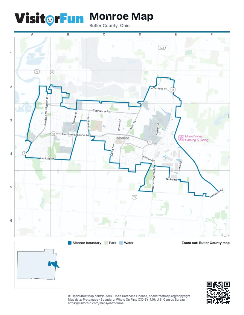
Street index of Monroe
Each street on the sheet and the grid squares it crosses.
- Hamilton Middletown RoadA2, A3, A4
- Niederlander LaneA2, B2
- Carol Ann LaneB2, B3
- De Bord LaneB2
- Serena WayB2
- Holman DriveC2, C3
- Cincinnati-Dayton RoadD2, D3
- Emerald WayD2
- Enterprise DriveD2
- Garver RoadD2, D3, E3, D4
- Greentree RoadD2, E2
- Bendel DriveE2, B3
- Anne RoadA3
- Apple Knoll LaneA3
- Apple Ridge CourtA3
- Autumn Oak CourtA3
- Buckeye DriveA3
- Coldwater DriveA3, A4
- Dazey DriveA3
- Granny Smith LaneA3
- Hamilton Lebanon Road EastA3, B3, C3, D3, D4
- Lakeview DriveA3, E3, A4
- Lindy DriveA3
- Macintosh LaneA3
- Old Hamilton Lebanon RoadA3
- Talls Oaks DriveA3
- Todhunter RoadA3, B3, C3, D3
- Wine Sap LaneA3
- Woodcrest DriveA3
- Ambergreen CourtB3
- Amity LaneB3
- Cherry Mill CourtB3
- Churchill Manor DriveB3
- Clark BoulevardB3, B4
- Crossings BoulevardB3, A4, B4
- Dorothy LaneB3
- Forest Pond DriveB3
- Greenoval DriveB3
- HaileyB3
- Hailey LaneB3
- Harbor CoveB3
- Heritage Trail DriveB3
- Hollybrook DriveB3
- Hollytree DriveB3
- Kelsey TrailB3
- Meadowood DriveB3
- Michelle LaneB3
- Northbrook LaneB3
- Oaklawn DriveB3
- Salzman RoadB3, B4
- Stone Ridge LaneB3
- Sutton Brook CourtB3
- Twin Cove DriveB3
- Valleybrook DriveB3
- Woodgate CourtB3
- Woodland CourtB3
- Yankee RoadB3, C3
- 1st Ohio AvenueC3
- Beckworth DriveC3
- Bedrock DriveC3, D3
- Britton LaneC3, C4
- Canterbury CourtC3, D3
- Chaney CourtC3
- CincinnatiC3
- Cornerstone DriveC3, D3
- Deneen AvenueC3, D3, E3
- Doverdale DriveC3
- Fox Run PlaceC3
- Gate House CourtC3
- Hanford LaneC3
- Heatherwood CourtC3
- Heritage Green DriveC3, C4
- Hickory Hill CourtC3
- Hornet DriveC3
- Indiana AvenueC3
- Kershaw CourtC3
- Lakeshore DriveC3
- Lee Price AvenueC3, C4
- Macready AvenueC3, C4
- Maumee DriveC3
- MiamiC3
- Mount Pleasant DriveC3
- MuskingumC3
- Muskingum CircleC3
- Nettleton CourtC3
- North Sands AvenueC3
- Northwestern AvenueC3
- Ohio AvenueC3, D3
- Paxton CircleC3
- Pebblestone DriveC3, D3
- Penbrooke CourtC3
- Ravenwood CourtC3
- Ridge Wood DriveC3, D3
- Ridgeway CourtC3
- Ring RoadC3, C4
- Scioto CircleC3
- Seminary DriveC3
- Slate Branch CourtC3
- Tarryton CourtC3
- Tennessee AvenueC3
- Weatherstone CircleC3
- Wexford DriveC3
- Wexford WayC3
- Wicklow LaneC3
- Winding Brook DriveC3, D3
- Winston LaneC3
- Wyandot Woods BoulevardC3, C4
- XeniaC3
- American WayD3, D4
- Brittony Woods DriveD3
- Brookhurst DriveD3
- Courtland DriveD3, D4
- East AvenueD3, D4
- Edgewood DriveD3
- Hidden Creek DriveD3
- Highland DriveD3
- Hunterbrook CourtD3
- Lawton AvenueD3, D4
- Nightstar CourtD3
- North Main StreetD3
- Overbrook DriveD3
- Parkview CourtD3
- South Main StreetD3, C4, D4
- Willington CourtD3
- Baker DriveE3
- Reed RoadE3
- Senate DriveE3, E4
- Union RoadE3, E4, E5
- Babbling Brooke DriveA4
- Bayberry LaneA4
- Blue Springs DriveA4
- Brandon DriveA4
- Braylon DriveA4
- Bridgewater LaneA4, B4
- Canal RoadA4
- David Lee CourtA4
- East Brooke DriveA4
- Ella CourtA4
- Griffin LaneA4
- Hankins RoadA4, B4
- Jerri CourtA4
- Jerry Couch BoulevardA4
- Kameron DriveA4
- Koehler DriveA4
- Lesourdsville West Chester RoadA4
- Maya CourtA4
- Morgan DriveA4
- Nicole CourtA4
- Riley LaneA4
- Riverstone WayA4
- Roden Park DriveA4
- Ryan CourtA4
- Sagewood CourtA4, B4
- Samuel DriveA4
- Scarlet CourtA4
- Scarlet Oak DriveA4
- Shanda DriveA4
- Shawn DriveA4
- Shyla CourtA4
- Songbird CourtA4
- Sonya CourtA4
- Springfalls CourtA4
- Stillwater TrailA4
- Thomas Pointe DriveA4
- Trey CourtA4
- Edison DriveB4
- Gabrielle DriveB4
- Logistics WayB4
- Mauds Hughes RoadB4
- Westheimer DriveB4
- Wright DriveB4
- Bernard DriveC4
- Carson RoadC4
- DouglasC4
- Ethel DriveC4
- Lee CourtC4
- Lee DriveC4
- Lena DriveC4
- Lewitt CourtC4
- Lynette CourtC4
- Mason AvenueC4
- Meadowlark LaneC4
- Moder DriveC4
- Old Orchard LaneC4, D4
- Rachel LaneC4
- Raymond DriveC4
- Sands AvenueC4
- Scott Alan DriveC4
- Shady CourtC4
- Sleepy Hollow DriveC4
- Stillpass WayC4, D4
- Sunset CourtC4
- Trails End DriveC4, D4
- Vista CourtC4, D4
- West Elm StreetC4, D4
- William Groh DriveC4, D4
- Willowbrook DriveC4
- Woodyard DriveC4
- Wyndham PlaceC4
- Austin Smith DriveD4
- Backtrail LaneD4
- Belmont LaneD4
- Bluegrass LaneD4
- Bobtail WayD4
- Boyd DriveD4
- Breaden DriveD4
- Bridle Creek DriveD4
- Bridle Pass WayD4
- Buggywhip CourtD4
- Butler Warren RoadD4, D5
- Cart Path DriveD4
- Church StreetD4
- Coachside CourtD4
- Conova DriveD4
- Creek CourtD4
- Davis DriveD4
- East Arielle CourtD4
- East Church StreetD4
- East Elm StreetD4
- Easton Manor DriveD4
- Elm StreetD4
- Ferncliff CourtD4
- Fieldstone CourtD4, D5
- Foalrun CourtD4
- Forest View CourtD4
- Furlong LaneD4
- Gallaher RoadD4
- Gallaher StreetD4
- Gorman CourtD4
- Helsinger DriveD4
- Hiteshue AvenueD4
- Jonah CourtD4
- Joy DriveD4, D5
- Keeneland CourtD4
- Kenwood CourtD4
- Keswick DriveD4
- Leah CourtD4
- Lebanon StreetD4
- Linn CourtD4
- Mason RoadD4
- Meadowlands DriveD4
- Meeker LaneD4
- New Garver RoadD4
- Obenour CourtD4
- Old Carriage CourtD4
- Old StreetD4
- Paddock LaneD4
- Pierson Sayre BoulevardD4
- PleasantD4
- Premium Outlets DriveD4, E4
- Randy LaneD4
- Redfox CourtD4
- Ridgepoint DriveD4
- Ridgeview LaneD4
- Rustic CourtD4
- Sackett DriveD4
- Saddle LaneD4
- Stablewatch CourtD4
- Steeplechase LaneD4
- Stewart WayD4
- Stonemill CourtD4
- Tam-O-Shanter WayD4
- Teil Tree CourtD4
- Timrick PlaceD4
- Trotter LaneD4
- Village CourtD4
- Walden CourtD4
- West Arielle CourtD4
- Woodsdale DriveD4
- Wren CourtD4, D5
- Wyndcrest CourtD4
- Corridor Park DriveE4
- Exploration DriveE4, E5
- Gateway BoulevardE4
- State Route 63E4
- W. K. Robinson DriveE4
- Brookfield LaneD5
- Brookside PlaceD5
- Hamilton RoadD5, F5
- Kyles Station RoadD5
- Nickel RoadD5, E5
- Rippling WayD5
- Waterbend CourtD5
- Navigator WayE5
Places on the map
- Berea Baptist Church
- Best Western Monroe Inn
- Brittony Woods Pond
- Butler Tech LeSourdsville Campus
- Chase
- Cincinnati Premium Outlets
- Clubhouse Sports Grille
- Columbia Care
- Crystal Tissue Landfill
- Culver's
- Fantasy Diner and Ice Cream Parlor
- Field Sports Arena Inc
- First Church of God Monroe
- First Financial Bank
- Gardner Metal
- Holiday Inn Express
- Housh Home Energy Experts
- Hustler
- Joe Morgan Honda
- Kroger
- LB Ranch
- LCNB
- Lemon Township
- Lux Mundi
- McDonald's
- Midpointe Library Monroe
- Monroe Bicentennial Commons Park
- Monroe Crossings Park
- Monroe Junior & Senior High School
- Monroe Library and Community Center
- Monroe Park
- Monroe Presbyterian Church
- Monroe Primary School
- MonRover Dog Park
- Mound Cemetery
- North Monroe Cemetery
- Rosemont Park
- Solid Rock Church
- Trader’s World Flea Market
- Treasure Aisles
© OpenStreetMap contributors, Open Database License, openstreetmap.org/copyright · Map data: Protomaps · Boundary: Who's On First (CC-BY 4.0); U.S. Census Bureau















