

Ohio map
Monroe Township map
About 16,609 people live here (Census Bureau, 2024 estimate). The sheet's index lists 300 streets; South County Road 25A, Tipp-Cowlesville Road and Troy-Frederick Road cross the most grid squares. Also on it: Freeman Prairie, Homestead Golf Course and Tipp City.
Open the map (PDF, US Letter)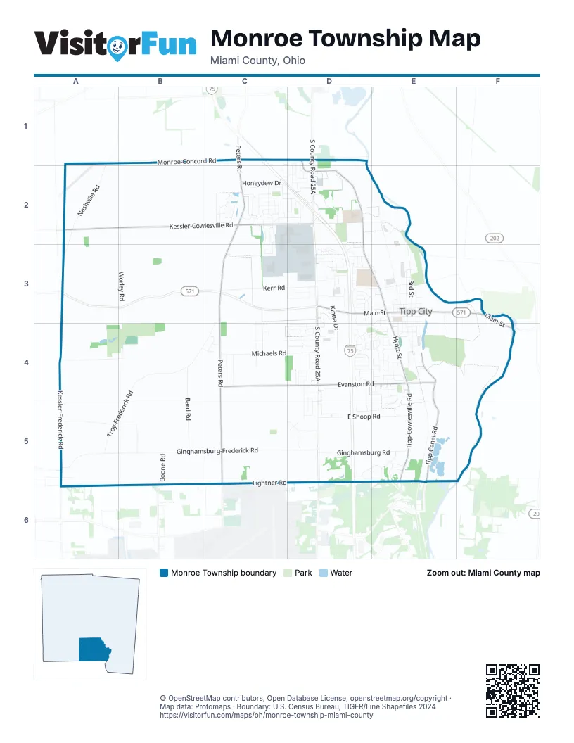
Street index of Monroe Township
Each street on the sheet and the grid squares it crosses.
- South County Road 25AD2, D3, D4, D5, D6
- East Main StreetE3, F3, F4
- West Main StreetD3, E3
- North Dixie DriveD6
- Frost RoadE6
- Peters RoadC2, C3, C4, C5
- West Kessler-Cowlesville RoadA2, B2, C2, D2
- Tipp-Cowlesville RoadD2, D3, E4, E5, E6
- Tipp Canal RoadE4, E5, E6
- Monroe-Concord RoadB1, C1, D1, D2
- East Evanston RoadD4, E4
- West Evanston RoadC4, D4
- Lightner RoadC6, D6
- South Hyatt StreetE3, E4
- North Hyatt StreetD3, E3
- Frederick-Garland RoadA5
- Dog Leg RoadB6
- Ginghamsburg-Frederick RoadA5, B5, C5, D5
- Worley RoadB2, B3, A4, B4
- Troy-Frederick RoadC3, B4, C4, A5, B5
- Kessler-Frederick RoadA4, A5, A6
- Nashville RoadA2, A3
- North 3rd StreetE2, E3
- Michaels RoadC4, D4
- Kerr RoadC3, D3
- East Shoop RoadD5, E5
- Ginghamsburg RoadD5, E5
- North Montgomery County Line RoadA6, B6
- Bard RoadB4, B5
- Chevington ChaseC2, C3
- North Montgomery County Line Road EastA6, B6, C6
- Kinna DriveD3, D4
- Burnside DriveD4, E4, E5
- Neal-Pearson RoadA5
- Donn Davis WayD2, E3
- West Broadway AvenueE3, E4
- Martindale RoadA5, B5
- Hathaway TrailD4, E4
- Honeydew DriveC2
- Copperfield LaneC2
- South Tippecanoe DriveD3, D4
- Wisteria DriveD1, D2
- David DriveC3, D3
- East Kessler-Cowlesville RoadD2
- West Pinehurst DriveC2, D2
- North 4th StreetE3
- South 1st StreetE3, E4
- Coach DriveD4
- Miles AvenueD3, E3
- South 3rd StreetE3, E4
- West Walnut StreetE3
- Woodlawn DriveC2, D2
- Stonehenge DriveC2
- Brookmere AvenueD4, E4
- Marjean DriveD4, D5
- Kent RoadC5, D5
- Floral Acres DriveD3
- Cider Mill WayD4
- Boone RoadB5, B6
- Bellaire DriveD3
- Oak Lea DriveC2
- Roberta DriveD4, D5
- Curtwood DriveD4, D5
- Phillip DriveC3, C4
- Country Estates DriveC4
- Petzoldt DriveC4
- Park AvenueE3
- North Branch RunC4, D4
- Rosenthal DriveC2
- West Dow StreetE3
- Weller DriveD3
- Wagon Wheel RoadE3
- Cedar Grove DriveC2, C3
- West Plum StreetE3
- Winding Way SouthD5, E5
- Bradley DriveC4
- South 5th StreetE3, E4
- Magnolia DriveD2
- Kiser DriveD3
- Harmony DriveD3
- Aspen DriveD4
- North Tippecanoe DriveD3, E3
- Barbara DriveE4
- North Westedge DriveD3, E3
- Cassandra DriveC2
- North 2nd StreetE3
- Maple Hill RoadE4
- North Garber DriveD3
- Whispering Pines AvenueE4
- Beechwood DriveE4
- Winding Way NorthD5, E5
- South 2nd StreetE3, E4
- Redbud DriveD2
- Crane RoadD2, E2
- Greensward DriveC2
- Winding WayE5
- Dwight DriveD3
- Sterling CourtD4
- Stonecress DriveE4
- Brookwood CirD4
- Honeysuckle DriveC1, D1, C2, D2
- South Garber DriveD3, D4
- Dogwood DriveD1, D2
- Allen Park DriveC4
- Sydney DriveC2
- Rosewood Creek DriveC2
- South 4th StreetE3, E4
- Windridge PlaceD3, E3
- Blauser DriveD4
- Springmeade LaneD3
- Rohrer DriveE3, E4
- Bowman AvenueE3
- Spring Garden DriveD3
- Heathwood DriveD2
- Heatherstone CourtE4
- Sycamore Woods DriveD4
- Parkwood DriveE3
- Primrose LaneE4
- Burr Oak DriveE4
- Teakwood RoadD2
- Curry Branch DriveD4
- Whispering Oaks TrailE5
- Comanche LaneD3
- Bejay DriveD4, D5
- Shirley DriveD4, E4
- Manchester DriveD3
- North 6th StreetE3
- Clover Hill DriveD4
- Cobblestone CornerD4
- Kitrina AvenueD5
- Bon Air DriveD3
- Commerce Park DriveD3
- Arapaho TrailD3
- Daylilly WayC2
- Diahann DriveC4
- Spring StreetC2
- Windsor CrossingD2, D3
- South 6th StreetE3, E4
- Hawk AvenueD4
- Essex DriveD4
- Meadow DriveD5
- Hampton StreetE4
- South 7th StreetE3, E4
- West German StreetE4
- Todd CourtD5, E5
- Devonshire AvenueD4
- Elderwood AvenueD4
- Douglas WayE4
- Detrick RoadC4
- Crow RoadA5
- Wunderwood DriveE4
- North 7th StreetE3
- Rosedale AvenueD3
- North 5th StreetE3
- Raymond DriveB4, C4
- Virginia DriveE5
- Chaucer LaneC2
- Hunters Ridge DriveE4
- Michele LaneC4
- Wind Rock DriveC2
- Charrington WayC2
- East Dow StreetE3
- Foxtail CircleD4
- East Plum StreetE3
- Tallow Tree WayE4
- Cheyenne PlaceD3
- East Walnut StreetE3
- Hawthorne DriveD4
- Fern AvenueE4
- Greenview DriveD4, E4
- West South StreetE4
- Winston LaneC2
- Sequoia CourtD3
- East Broadway AvenueE3
- East Elm StreetE4
- Shoshoni WayD3
- Larch StreetD3
- Hartman AvenueD3
- Warner DriveD3
- North Willow Glen AvenueD4
- Amokee PlaceD3
- Thornapple WayC2
- West Elm StreetE4
- Rosedale DriveD4, E4
- Stone Ridge PlaceC2
- Aster LaneD3
- Hermosa DriveC2
- Horton AvenueE4
- Pinehurst DriveC2
- MacIntosh CourtC2
- Kilgore BoulevardE3
- Pine StreetE4
- Chelsea LaneC2
- East South StreetE4
- Millstone DriveD4
- Pebble PlaceD4
- Maxwell CourtD4
- Gardenia DriveD2
- Larkspur DriveE4
- Michael PlaceE4
- Buckeye CourtD4
- Quartz LnD4
- Scenic KnollD5, E5
- Silver DriveD4
- Edwards DriveE5
- Banyon Tree WayD3
- Lilac LaneD2
- North 1st StreetE3
- Scottsdale DriveC4
- Yorkshire RoadE4
- Lantana CourtE4
- York Meadow DriveE4
- Tulip LaneD2
- Flagsstone WayD4
- Poplar DriveE4
- West Franklin StreetE3
- Cliffwood DriveD5
- Judith DriveE4
- Cayman CircleE4
- Greenmantle DriveC2
- Trader CourtD1
- Maynard DriveE3
- Hazeldean CourtC2
- Tweed DriveD3
- Thornburg PlaceE3, D4
- Elas CourtD2
- Tipp Industry Park CourtE2
- Spruce CourtD4
- Tamarak DriveD4
- Richard GlenC2, D2
- South Willow Glen CourtD4
- Eidemiller DriveC2
- Fairlawn CourtD2
- Rolling Acres DriveD4
- Kyle DriveE3
- Brookhill Woods LaneE3
- Dean CourtD5, E5
- Kim Circle NorthD5
- Hickory Hill DriveE4
- Chestnut DriveD3
- Hardwick CourtC2
- Wild Plum DriveC2
- Maeghann CourtE4
- Revelstoke CourtE4
- Shirl RoadC4
- Krystal Ellen DriveD4
- Bittersweet DriveD2
- Kim Circle SouthD5
- Storm CourtE4
- Smith StreetE4
- Sunflower PlaceD3
- Deer Creek PathD5
- Estates DriveD4
- Jackson CourtC2
- Verdi DriveC2
- Wind Rock CourtC2
- Fern CourtE4
- Cottonwood Creek DriveE4
- Wilderness BluffE5
- Ford AvenueE3
- Willhelm StreetE4
- East German StreetE4
- Franklin StreetE3
- Marigold CourtD3
- Columbine CourtE4
- Donview CircleE4
- Saint Leonards LaneD2, D3
- Miami StreetE3
- Monroe StreetE3
- Ohio StreetE3
- Claymore CourtC2
- Union StreetE3
- Baneberry CourtE4
- North DriveE3
- Rebekah CourtC3
- Surrey DriveC4, D4
- Jacob CourtC3
- Crane StreetE3
- Cunningham CourtD3
- Daisy CourtD3
- New StreetE3
- Wingrove CourtE4
- English CourtE4
- June DriveC2
- Rosebud CourtD3
- Arapaho CourtD3
- Rustic Run RoadE5
- Tyler LaneD4
- Woodward StreetE4
- Kiowa CourtD3
- Krystal Ellen LaneD3
- Lancaster LaneE4
- Iris DriveD3
- Nelson CourtD4
- Oak DriveD4
- Lennox CourtE4
- Jeffrey LaneC4
- Juniper CourtD4
- Shane CourtD4
- Stone Ridge CourtC2
Places on the map
- Band Practice Field
- Big Boy
- Bob Evans
- Broadway Elementary School
- Casey's General Store
- Charis
- Circle K
- City Park
- CVS Pharmacy
- DeerCliff Park
- Empire Machine
- Freeman Prairie
- Ginghamsburg Church
- Gospel Lighthouse Church
- Hathaway Park
- Hathaway Village Park
- Hickory River Smokehouse
- Holiday Inn Express
- Homestead Golf Course
- Honda Certified Used Cars
- Hyatt Family Care
- L. T. Ball Intermediate School
- La Quinta Inn & Suites
- Lesher Woods
- Liberty Life Church
- Maple Hill Cemetery
- McDonald's
- Menards
- Monroe Cemetery
- Monroe Federal
- O'Reilly Auto Parts
- Pearson Cemetery
- Thomas B. Kyle Senior Memorial Park
- Tipp City
- Tipp City Post Office
- Tipp City Public Library
- Tippecanoe High School
- Troy Skypark
© OpenStreetMap contributors, Open Database License, openstreetmap.org/copyright · Map data: Protomaps · Boundary: U.S. Census Bureau, TIGER/Line Shapefiles 2024















