

Ohio map
Oxford map
About 22,585 people live here (Census Bureau, 2024 estimate). The sheet's index lists 242 streets; College Corner Pike, Fairfield Road and Dana Drive cross the most grid squares. Things to do inside the boundary: Enjoy Oxford Visitors Bureau.
Open the map (PDF, US Letter)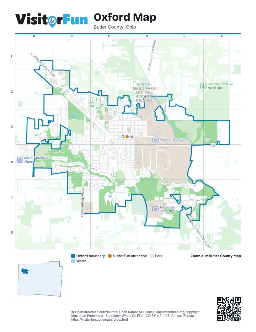
Street index of Oxford
Each street on the sheet and the grid squares it crosses.
- College Corner PikeA1, A2, B2, B3, C3
- Ringwood RoadA1
- Todd RoadA1, A2
- Angela CourtB2
- Baker DriveB2
- Cannery RowB2
- Carter CourtB2, C2
- Country Club DriveB2, B3
- Day DriveB2
- Debbie DriveB2
- Douglas DriveB2
- Fuller WayB2, C2
- Gail DriveB2, B3
- Grace LaneB2
- Hester RoadB2, B3
- Jacob DriveB2, C2
- Judy DriveB2, B3
- Melanee DriveB2
- Merry Day DriveB2
- Miami DriveB2
- Michelle DriveB2, B3
- Olde Farm RoadB2, B3
- Park LaneB2
- Reaghs WayB2
- Christopher DriveC2, D2
- Dufour LaneC2
- Hawks LandingC2, C3
- Honor LaneC2
- Indian Cove CircleC2, C3
- Jeffrey DriveC2
- Kelly DriveC2, D2
- Miami TrailC2, C3
- Northridge DriveC2, C3
- Red Cedar CircleC2
- Westgate DriveC2, C3
- Bonham RoadD2, E2, D3
- Morning Sun RoadD2, C3, D3
- Weeb Ewbank WayD2, D3
- Contreras RoadA3, B3, C3
- Creekside LaneA3
- Fairfield RoadA3, B3, B4, C4
- Ivywood SquareA3
- Kay Rench DriveA3, A4
- Knollwood DriveA3
- Redbud TraceA3
- Savannah DriveA3, B3
- Scarlet Oak CircleA3
- Stone Creek DriveA3, B3
- White Tail RunA3
- Woodcrest WayA3
- Charity PathB3
- Devonshire DriveB3
- Erickson DriveB3, B4
- Fieldcrest DriveB3
- Hidden Creek DriveB3, B4
- Hilltop RoadB3, C3
- Olde Stone CourtB3
- Panda LaneB3
- Patrick DriveB3
- Pin Oak DriveB3
- Prevalent DriveB3
- Ridge AvenueB3, B4
- Timothy LaneB3
- Tollgate DriveB3, B4, C4
- Vereker DriveB3, C3
- Applewood CircleC3
- Brown RoadC3
- Dick RoadC3
- East Church StreetC3, D3
- East Collins StreetC3, D3
- East High StreetC3, D3
- East Park PlaceC3, D3
- East Sycamore StreetC3, D3
- East Vine StreetC3, D3
- East Walnut StreetC3, D3
- Jacqueline DriveC3
- James RoadC3
- Joseph DriveC3
- Lincoln AvenueC3
- Lynn AvenueC3, C4
- Marti CourtC3
- Meadow CircleC3
- North Beech StreetC3
- North College AvenueC3
- North Elm StreetC3
- North Locust StreetC3
- North Main StreetC3
- South Beech StreetC3, C4
- South College AvenueC3, C4
- South Elm StreetC3, C4
- South Locust StreetC3, C4, C5
- South Main StreetC3, C4
- Union StreetC3, C4
- Vicki Anda CourtC3
- West Church StreetC3
- West Collins StreetC3
- West High StreetC3
- West Park PlaceC3
- West Sycamore StreetC3
- West Vine StreetC3
- West Walnut StreetC3
- West Withrow StreetC3
- Bishop CircleD3
- Bishop StreetD3
- Bouden LaneD3
- East Withrow StreetD3
- Homestead AvenueD3
- Irvin DriveD3, D4
- McGuffey DriveD3, D4
- North Campus AvenueD3
- North Fisher DriveD3, E3
- North Patterson AvenueD3
- North Poplar StreetD3
- South Campus AvenueD3, D4
- South Fisher DriveD3, D4
- South Patterson AvenueD3, D4
- South Poplar StreetD3, D4
- Tallawanda RoadD3
- University AvenueD3
- Willow LaneD3
- Woodruff CourtD3
- Retreat LaneE3, E4
- Oxford Milford RoadF3
- Autumn DriveA4, B4
- Brookville RoadA4, B4
- Lantern Ridge RoadA4, B4
- Albert CircleB4
- Anderson DriveB4
- Brigid CircleB4
- Bull Run DriveB4
- Carrie CircleB4
- Chestnut Hill DriveB4
- Cobblestone CourtB4
- Dana DriveB4, C4, B5, C5
- Deer Trail CircleB4
- Emerald Woods DriveB4, C4
- Fox Run CircleB4
- French DriveB4
- Glos DriveB4, C4
- Harvest CourtB4
- Heather Ridge CourtB4
- Highmeadow LaneB4
- Hunter Woods DriveB4
- Melinda DriveB4, C5
- Melissa DriveB4, C4
- Oxford Reily RoadB4, B5
- Pine LaneB4
- Quail Ridge DriveB4
- Robin CourtB4
- Spruce LaneB4
- Stonehedge CircleB4
- West Bull Run DriveB4
- West Chestnut StreetB4, C4
- White Oak DriveB4
- Windingbrook DriveB4
- Brill DriveC4
- Brookview CourtC4
- Charleston DriveC4
- ChurchillC4
- Churchill RoadC4
- Churchill TrailC4
- Clover CircleC4
- Collins Run RoadC4
- Day CircleC4
- East Central AvenueC4, D4
- East Chestnut StreetC4, D4
- East Rose AvenueC4, D4
- East Spring StreetC4, D4
- Edgehill DriveC4
- Eisenhower WayC4
- Elm StreetC4
- Erin DriveC4
- Foxfire DriveC4
- Gaslight AvenueC4
- Heather LaneC4
- Kehr RoadC4, C5
- Linden AvenueC4, D4
- Linnwood LaneC4
- Marilyn DriveC4
- Maxine DriveC4, C5
- McGuffey AvenueC4
- Miami CommonsC4
- Oberlin CourtC4
- Ogden CourtC4
- Oxford CommonsC4
- Pamela DriveC4
- Reagan PlaceC4
- Thatcher LoopC4
- Wells Mill DriveC4
- West Central AvenueC4
- West Rose AvenueC4
- West Spring StreetC4
- Wooster PlaceC4, D4
- Acorn CircleD4, D5
- Ardmore DriveD4
- Arrowhead DriveD4, D5
- Bern StreetD4
- Cedar DriveD4
- Center DriveD4
- Chestnut LaneD4
- Garrod LaneD4
- Harris DriveD4
- Maple AvenueD4
- Oak StreetD4
- Oxford Millville RoadD4, D5, E5, E6
- Oxford Trenton RoadD4, E4, F4
- Plum StreetD4
- Poplar StreetD4
- Silvoor LaneD4
- Western College DriveD4, E4
- Springwood DriveF4
- Daniel DriveB5
- David DriveB5, C5
- Josie LaneB5
- Marcia DriveB5, C5
- Randall DriveB5
- Ryan DriveB5
- Callie LaneC5
- Gardenia DriveC5
- Glenview DriveC5
- K Bell RoadC5
- Morgan CircleC5
- Roberts DriveC5
- Sandra DriveC5
- Silverleaf DriveC5
- Red Cloud CourtD5, E5
- University Park BoulevardD5, E5
- University Park DriveD5
- Cottonwood DriveE5
- Dogwood DriveE5
- Indian Trace DriveE5
- Ironwood DriveE5
- Lake Forest DriveE5, E6
- Magnolia DriveE5
- McKee AvenueE5
- Miami Western DriveE5
- Peabody DriveE5
- Sassafras DriveE5
- Southpointe ParkwayE5
- Spartan DriveE5
- Tenney CourtE5
- Thomson CourtE5
Things to do on the Oxford map
Places on the map
- Ace Hardware
- Animal Care Clinic
- Bachelor Preserve - Marcum
- Becks Preserve
- Ben Roethlisberger Field
- Best Western Sycamore Inn
- Bishop Woods
- Bobby Kramig Field
- Brick Street
- Bunger Quad
- Butler County Court
- Butler Inn
- Campus Avenue Garage
- Central Quad
- Chestnut Fields
- College Woods
- Comfort Inn
- Conrad Formal Gardens
- Cook Field
- Cradle of Coaches Plaza
- Cross Country Trail
- Equestrian Center
- Four Mile Creek
- Kramer Elementary School
- Leonard Howell Park
- Miami University
- Oxford Cemetery
- Oxford Community Park
- Oxford Police Department
- Peffer Park
- Peffer Woods
- Silvoor Biological Sanctuary
- Talawanda High School
- Talawanda Middle School
- The UPS Store
- Walmart Supercenter
- Western Woods
Next to Oxford
- Austin-Magie Farm and Mill Historic District
© OpenStreetMap contributors, Open Database License, openstreetmap.org/copyright · Map data: Protomaps · Boundary: Who's On First (CC-BY 4.0); U.S. Census Bureau















