

Ohio map
Pickerington map
About 25,814 people live here (Census Bureau, 2024 estimate). The sheet's index lists 300 streets; Hill Road North, Diley Road and Refugee Road cross the most grid squares. Also on it: Refugee Road Medical Corridor, Violet Township and Pintail Marsh.
Open the map (PDF, US Letter)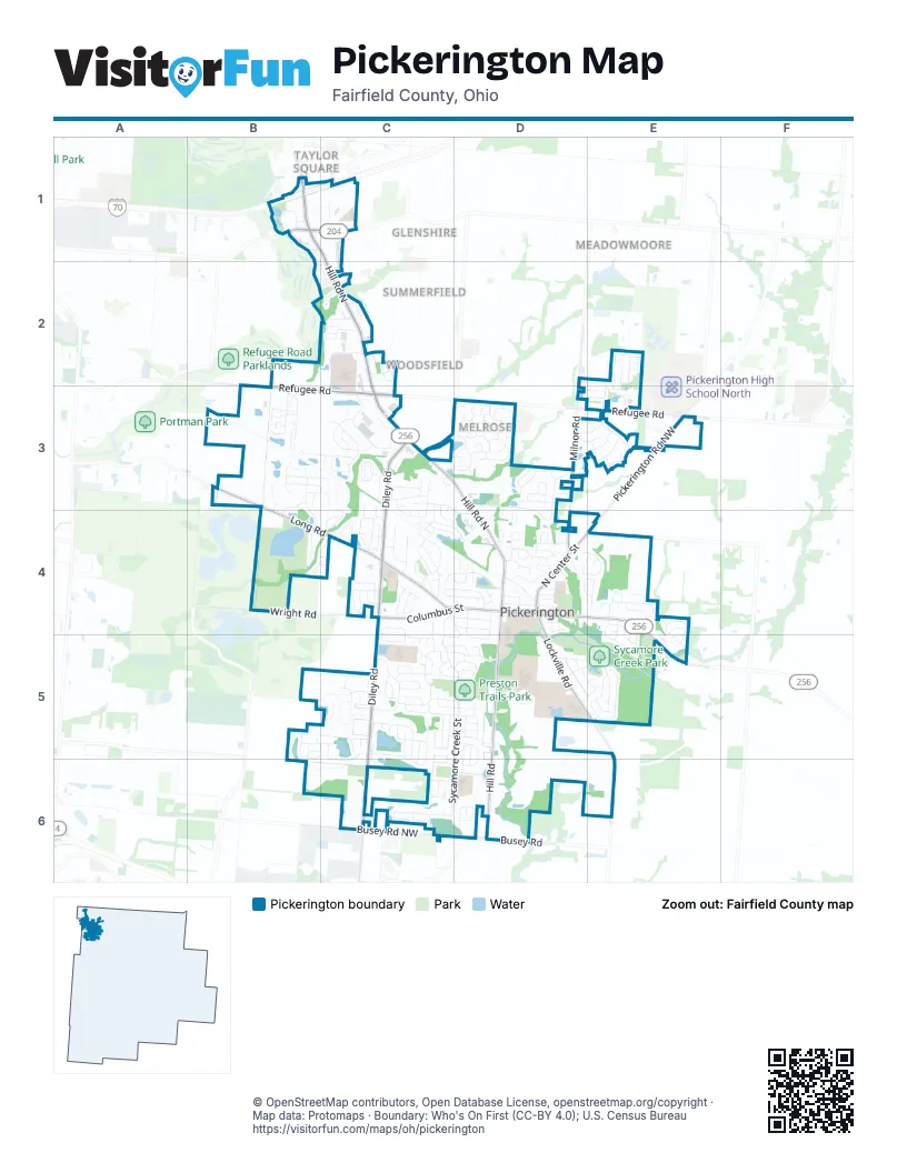
Street index of Pickerington
Each street on the sheet and the grid squares it crosses.
- Diley RoadC3, C4, C5, C6
- Hill Road NorthB1, C1, C2, C3, D3, D4
- Refugee RoadB2, B3, C3, E3
- West Columbus StreetC4, D4
- East Columbus StreetD4, E4, E5
- Reynoldsburg Baltimore Road NorthwestE5
- Baltimore-Reynoldsburg RoadB1
- Long RoadB3, B4, C4
- Pickerington Road NorthwestE3, E4, E5, E6
- Hill RoadD5, D6
- Lockville RoadD4, D5, E5
- Milnor RoadD2, D3, D4
- Hill Road SouthD4, D5
- Wright RoadB4, C4
- North Center StreetD4, E4
- Blacklick-Eastern Road NorthwestB1, C1
- Busey Road NorthwestC6
- Tussing RoadB1
- Busey RoadD6
- Stemen RoadE4
- Sycamore Creek StreetD5, C6, D6
- Courtright DriveC3, D3, D4
- Fox Glen Drive EastC5, C6
- Brevard CircleC5, C6
- Stonecreek DriveC2, C3
- McLeod ParcC3, D3
- Gray DriveC3
- Melrose BoulevardD3
- Opportunity WayD5
- Stonebridge BoulevardC5, D5
- Windmiller DriveC3
- Fullers CircleB3
- Preston Trails DriveC5
- Tyler AvenueB1, C1, C2
- Pickering DriveD5, E5
- Yale CircleC5
- Fairfield DriveD6
- Evergreen CircleC4
- Rambling Brook DriveC5, D5
- Sycamore DriveE5
- Meadows BoulevardD4
- Zeller CircleC6
- Courtland LaneC3, C4, D4
- Colony Park DriveC4
- Timber Ridge DriveE4
- Balsam DriveC5, C6
- Pruden DriveC4, D4
- Autumn Ridge CircleD6
- Lorraine BoulevardC4, D4, C5, D5
- Flat River StreetC5, D5
- Willow Run DriveD4, C5, D5
- Delong StreetC3
- Blue Jacket CircleE4, E5
- Springcreek DriveE3
- Arlington DriveD4, E4
- Raab StreetC5
- Mackenzie DriveE4, E5
- Ebright LaneE2, E3
- Longleaf StreetB5, C5
- Brighton StreetC5, D5
- Lakes Edge WayC4, D4
- Fox Glen DriveC5, C6
- Manchester DriveC5
- Kelburn LaneD3, D4
- Balderson DriveB3, B4
- Washington StreetB3, C3
- Pickerington Ridge DriveB3
- Linden CircleB5, C5, B6
- Seven Pines DriveC4, D4
- Pickerington Hills DriveE5
- Lilac CircleC3
- Park AlleyD4
- Chanticleer Drive NorthwestD3, E3
- Town Square DriveD4
- Leasure DriveB4, C4
- North East StreetD4
- Hilltop DriveE5
- Wooster StreetD5, D6
- Bridgewater Drive NorthwestE3
- North Starr DriveC3
- Peggy Green LaneD4
- Postage CircleC2
- Carver StreetC5, D5
- Longview StreetD4
- Morningview AvenueD5, E5
- Pioneer CircleC4
- Milford DriveD3
- Sheryl DriveC4, D4
- Herrogate SquareC5, D5
- Florence DriveC4
- Georges Creek DriveC4
- Westbury DriveD3
- Olde Mound LaneE4
- Cherry Hill DriveC3
- Parkwood AvenueC4
- Dunvegan CircleD3
- Turnberry DriveB1, B2, C2
- Carrowmoore DriveB3, C3
- Cross Creeks BoulevardC2
- Taylors WayE2, E3
- Montmorency Drive SouthC3, C4
- Ra-mar DriveD5, E5
- Rooster Tail DriveE2
- Great Trail StreetB3
- Pearl LaneC4
- Daventry Drive NorthwestE3
- Willard DriveE4
- Salisbury StreetC5
- Treemoss StreetB3
- Old Diley RoadC3
- Brookside DriveC3, D3
- Montmorency Drive EastC3, C4
- Wharncliff LoopD3
- Fuller's WayB3
- Lorriane DriveD4
- Lillian DriveC5
- Selkirk WayD3
- Hereford DriveD5, E5
- Yarmouth RoadC1
- Commerce DriveC3, D3
- Greenwood DriveE2, E3
- Knightsbridge Drive NorthC4
- West Church StreetD4
- Alexander Lawrence DriveD4
- Grinnell StreetC5
- Thrush CircleC5
- Crestwock CourtB3
- Carron CircleD3
- Kaye DriveD4
- Larkspur WayC3
- Shawnee DriveE4, E5
- Streamside RoadB3
- Ludham TrailD3
- Violet Drive WestC4, D4, D5
- Freedom Way NorthC1
- Durand StreetB5, C5
- Canteridge DriveC5
- Albion StreetD5, D6
- McMunn StreetC3
- Alyssa DriveC4
- Monebrake DriveB4
- Warwick LaneC3, C4
- Jamie Lynn CircleD4
- Brandy Hill DriveC5, D5
- Cross Creeks RidgeC2
- Roxberry DriveE4, E5
- William Henry LnC3
- Patterson StreetC4, D4
- Maple AvenueC4
- Parkview DriveC4
- Robinette StreetC3, C4
- Exeter StreetC5
- Pleasant View DriveE2, E3
- Preserve DriveB3, B4
- Littleton DriveD3
- Manchester CircleC4, C5
- Theron DriveC5
- Birchwood StreetC2
- Urich DriveC4
- Avalone DriveC4
- Banbridge StreetC5
- Manchester Circle NorthC4
- Covered Bridge LaneD5
- Graystone DriveD2, E2
- Columbia DriveD4
- Lakeview DriveD4
- Pickerington Ponds DriveC5
- Winderly LaneB1
- Kingston CircleD4
- Skyline LaneE5
- Norfolk Square NorthC5
- Penn StreetC6, D6
- Langtree DriveC4
- Meadow DriveD4, D5
- Knightsbridge Drive WestC4
- Vantage Point PlaceE4
- Poplar StreetC4
- Clint DriveC2
- Elgin CircleD3
- Avebury DriveD3
- Brookview CircleC2
- North Corkwood CourtC5, C6
- Tallow StreetC5, C6
- Homestead DriveD4
- Kelford DriveB3, C3
- Evening WayD4
- Sourwood StreetC5
- Roundwood CourtC5
- Gayle DriveC4
- Lanning StreetC6, D6
- Zeller DriveC6
- Anita DriveD4, E4
- Postage DriveC2
- Janice LaneC4
- Knightsbridge Drive EastC4
- Heatherbrook CircleB3
- Redbud RoadC3
- Furman StreetD5, D6
- Vanderbuilt StreetD5
- Marie DriveC4, C5
- Norfolk Square SouthC5
- Oakview CourtE4
- Shannon DriveD4
- England StreetD4
- Cross StreetD4
- Hillview StreetD4
- Glengary CourtE4, E5
- Mulberry StreetC5
- Overlook CourtC2
- Elmwood StreetC4
- Corday BoulevardD4, E4
- Rapala LaneE2
- Andrea LaneC4
- Antrim StreetC5
- Kirkhope DriveB3
- Lands End CircleC4
- Glencrest DriveE3
- Cherry Blossom DriveE3
- Grisby LaneC4
- Bretforton StreetD3
- Mark StreetD4
- Field Harvest AvenueD5
- Kohler StreetC5
- West Borland StreetD4
- Alderpoint TerraceD3, E3
- East Church StreetD4
- Reynolds AvenueD4
- East Borland StreetD4
- Fresno StreetC6
- Drexel PlaceD4
- Ledford DriveC4, C5
- Bristo StreetE4
- Macfie StreetE4, E5
- Fox Glenn EastC5
- Pathlow DriveD3
- Inverness GlenD3
- Mockingbird CourtD4
- Jericho RoadD4
- Pheasant LaneD4
- Stewart CourtD3
- Millwood Drive NorthwestE3
- Ravine DriveD3
- Stone Mill RoadD5
- Edgewater DriveE3
- Splashtail CourtE2
- Ashton StreetD4
- Audubon StreetB5
- Brackbill CourtD4
- Bruce Court NorthwestC6
- Raine StreetD4
- Courtright CourtC3
- Village Mill RoadD3
- Leaning Fence CourtD5
- Pagoda CourtB5
- Marie AvenueC5
- Jennifer Leanne CircleD4
- Overland BoulevardD4
- South East StreetD4
- Gnarled Oak StreetC5
- Simsbury CourtE5
- Paisley PlaceD3
- Beechnut StreetB5
- Creekside LaneB1
- Rolling Meadow CourtC3, C4
- Lookout LaneC4
- Farber StreetD5
- High Point StreetD5
- Quail Hollow CourtE4
- Lake Pond CourtD4
- Emmaus DriveC3, C4
- Bedford CourtD4
- Blossom LaneC3
- Cornstalk StreetE5
- Losey DriveC4
- Fair Oaks LaneD4
- Fanchers StreetD4
- Spinner CourtE2
- Coffeetree CourtC5
- Ione CourtC6
- Valley LaneD5
- Lismore PlaceD3
- Ward StreetB3
- Melody LaneC3
- Dunmore CourtD3
- Banbridge CourtC5
- Cambridge WayC2
- Charles CourtC2
- Lynette DriveD5, E5
- Belstone StreetC2
- Loving WayD4
- Prestfield CircleB3
- Victory CourtE4
- Whitney CircleB1
- Northern AvenueD4
- Glades StreetB3
- Morello CourtC3
- Nadine AvenueD4, E4
- Aberdeen CourtD3
- Somerset WayC2
- Boggs CourtC3
Places on the map
- Advance Auto Parts
- Aldi
- Arby's
- Barnes & Noble
- BEST WESTERN Executive Suites - Columbus East
- Bob Evans
- Cato
- Chase
- Circle K
- City Of Pickerington Park And Recreation Department
- CME Federal Credit Union
- Colony Park
- Comfort Inn
- Cracker Barrel
- CVS Pharmacy
- Diley Middle School
- Dovel Memorial Cemetery
- DQ Grill & Chill
- Dwayne R. Spence Funeral Home
- Epiphany Lutheran Church
- OhioHealth Pickerington Methodist Hospital
- Pickerington Area Soccer Association
- Pickerington Central Junior High School
- Pickerington Elementary School
- Pickerington High School Central
- Pickerington Youth Athletic Association
- Pintail Marsh
- Preston Trails Park
- Refugee Road Medical Corridor
- Simsbury Disc Golf Course
- Simsbury Park
- St. Elizabeth Ann Seton Parish
- Sycamore Creek Elementary
- Sycamore Creek Park
- Sycamore Creek Park Arboretum
- Sycamore Park Pond
- The UPS Store
- Victory Park
- Violet Township
- Willow Pond Park
Next to Pickerington
- Ashley Creek
- Bentwood Farms
- Chevington Woods
- Chevington Woods North
- Eastchester
- Glenshire
- Meadowmoore
- New England Estates
- Summerfield
- Taylor Square
- Woodsfield
© OpenStreetMap contributors, Open Database License, openstreetmap.org/copyright · Map data: Protomaps · Boundary: Who's On First (CC-BY 4.0); U.S. Census Bureau















