

Ohio map
Streetsboro map
About 17,877 people live here (Census Bureau, 2024 estimate). The sheet's index lists 282 streets; State Route 43, Ohio Turnpike and Cleveland East Liverpool Road cross the most grid squares. Also on it: Boulder Creek Golf Club, Osprey Loop and Sahbra Farms.
Open the map (PDF, US Letter)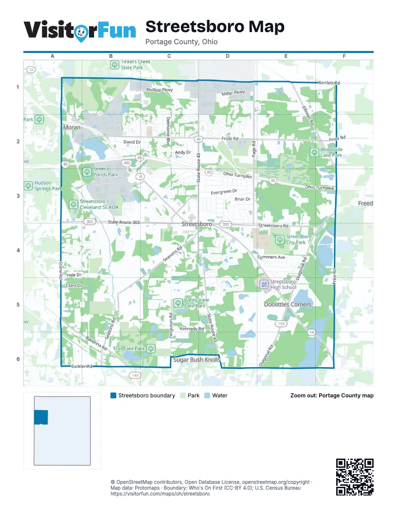
Street index of Streetsboro
Each street on the sheet and the grid squares it crosses.
- Wellman RoadA1, A2, B2
- Aurora Hudson RoadB1, A2, B2
- Brushwood DriveB1, B2
- Buckhorn TrailB1, B2
- Holborn RoadB1, C1, B2, C2
- Jenwood CourtB1, C1
- Phillipp ParkwayB1, C1, B2
- Alden DriveC1
- Crane Centre DriveC1, D1
- Dawnwood CourtC1
- Delores DriveC1, C2
- Edgewood LaneC1
- Ethan AvenueC1
- Gloucester RoadC1, C2
- Hazelton RoadC1, C2
- North Delmonte BoulevardC1, C2
- Ridgeview CourtC1, C2
- South Chillicothe RoadC1
- Sparrow RunC1
- State Route 43C1, D1, C2, D2, C3, C4, D4, D5, D6
- Tinkers Green DriveC1, C2, D2
- Danner DriveD1
- Dunlap DriveD1
- Janet DriveD1
- Jennifer LaneD1, D2
- Keith's ClosD1
- Kendall LaneD1, D2
- Miller ParkwayD1
- Page RoadD1, D2, D3, D4
- Singer DriveD1
- West Wason DriveD1
- Bartlett RoadE1, F1
- Elliman RoadE1, E2, F2
- Bates DriveA2
- Hudson Aurora RoadA2
- Ohio TurnpikeA2, B2, C2, C3, D3, E3, F3
- Antler TrailB2, C2
- Bridgeport AvenueB2
- David DriveB2, C2
- Diane AvenueB2, C2
- Edmond AvenueB2
- Ellsworth RoadB2
- Fawn CourtB2
- Forbes DriveB2, C2
- Fox Run CourtB2
- Frost RoadB2, C2, D2, E2, F2
- Greentree ParkwayB2, C2
- Mallard CourtB2
- Mopar DriveB2, B3
- Newport LaneB2
- Providence CourtB2
- Ravenwood CourtB2
- Raymond StreetB2
- Rodney StreetB2
- Stewart AvenueB2
- Adele DriveC2
- Andy DriveC2
- Beverly LaneC2
- Bristol LaneC2
- Creekledge CourtC2
- East Kensington LaneC2
- Fairacres AvenueC2
- Forest Valley LaneC2
- Fronek DriveC2
- Gaynelle AvenueC2
- Greenhaven StreetC2
- Heath LaneC2
- Heinsley PlaceC2
- Highland CourtC2
- Highland WayC2
- Hunter Ridge DriveC2
- Meldon DriveC2
- Michael DriveC2
- Montclair DriveC2
- Navajo TrailC2, C3
- Pennsylvania AvenueC2
- Poston RoadC2
- Ridgeside CourtC2
- Seminole Trail NorthC2, C3
- South Delmonte BoulevardC2
- Strafford CourtC2
- Sunny LaneC2
- Vantage WayC2, D2
- West Kensington LaneC2
- Westridge LaneC2
- Woodside CourtC2
- Boulder Creek WayD2, E2
- Clarius Circle EastD2
- Dann's WayD2
- Eagle LaneD2
- Fairways DriveD2, E2
- Gene's WayD2
- Guenevere StreetD2
- Hannum DriveD2, E2
- King Arthur WayD2
- Lady AnneD2
- Lady CatherineD2
- Lady Catherine CourtD2
- Lancelot StreetD2
- Manfrass DriveD2
- Mara CircleD2
- Meadow Ridge DriveD2, E2
- Merlyn LaneD2
- Mids CourtD2
- Mordred LaneD2
- Morgan LaneD2
- Morgan WayD2
- North Sagramore DriveD2
- Pellinore LaneD2
- South Sagramore DriveD2
- Springside CircleD2, E2
- Squire RoadD2
- Walsh DriveD2
- Warwick StreetD2
- William Henry DriveD2
- Woods DriveD2, E2
- Autumn Ridge DriveE2
- Creekside WayE2
- Deer RunE2
- Prestwick CourtE2
- Woodview CircleE2
- State Route 303A3, B3, C3, C4
- Crownwood CourtB3
- Gold Leaf CourtB3
- Hickory Grove CourtB3
- Hickory Hill CourtB3
- Hickory Ridge DriveB3
- Jefferson StreetB3
- Mondial ParkwayB3, C3
- Redhawk DriveB3, B4
- Rosemont DriveB3
- SR 303 BypassB3, B4
- Sweetnut CourtB3
- Adena CircleC3
- Apache PassC3
- Cecil DriveC3, D3
- Cherokee TrailC3
- Chestnut CourtC3
- Classic DrC3
- Cleveland East Liverpool RoadC3, C4, D4, E4, E5, E6, F6
- Delaware TrailC3
- Evergreen DriveC3, D3
- Hidden Valley LaneC3
- Kickapoo PassC3
- Market Square DriveC3, C4
- Olga AvenueC3
- Pike ParkwayC3, D3
- Redwood LaneC3
- Richard A. Taiclet WayC3, D3, C4, D4
- Russell DriveC3, D3
- Shady Lake DriveC3
- Shawnee CircleC3
- Shawnee TrailC3
- Singletary DriveC3
- Staples DriveC3
- Walters RoadC3, C4
- Blitz LaneD3
- Briar DriveD3, D4
- Cisar DriveD3, E3
- Crock DriveD3
- Dorothy DriveD3
- Ellen DriveD3
- Flora DriveD3
- Gerald DriveD3
- Gillie DriveD3
- June DriveD3
- Lakeside DriveD3, D4
- Lido LaneD3
- Luke DriveD3
- Manor DriveD3
- Mitchell DriveD3
- Mount Vernon DriveD3, D4
- Murial DriveD3
- Myers DriveD3
- Nita LaneD3
- Root DriveD3, D4
- Seymour DriveD3
- Sidney DriveD3
- St Charles DriveD3
- St Nicholas DriveD3, D4
- Steffner DriveD3
- Tower DriveD3
- Walker DriveD3
- Streetsboro RoadF3, D4, E4, F4
- Crystal CourtA4
- Diamond BoulevardA4
- Emerald AvenueA4
- Hale DriveA4, B4
- Hawkesbury BoulevardA4
- Highridge DriveA4
- Jade BoulevardA4, B4
- McCracken RoadA4, B4
- Ruby LaneA4, B4
- Sapphire LaneA4, B4
- Stone RoadA4, A5
- Topaz TerraceA4
- Victorridge DriveA4, B4
- Drake CourtB4
- Egret CourtB4
- Falcon DriveB4
- Garnet WayB4
- Killdeer CourtB4
- Kingfisher CourtB4
- Opal CourtB4
- Sandpiper DriveB4
- Stoneridge DriveB4
- Teal CourtB4
- Tern CourtB4
- Warbler CourtB4
- Wood Duck CourtB4
- Wood Thrush DriveB4
- Broad StreetC4
- Colony DriveC4, D4
- Ferguson RoadC4, C5, C6
- Seasons RoadC4, B5, C5, B6
- Streetsboro CrossingC4
- Annalane DriveD4, E4
- Clover CourtD4
- Crescent DriveD4
- Dublin WayD4
- Duncan WayD4, D5
- Flannery CourtD4
- Irish CricleD4
- Kelly LaneD4
- Maple Grove CourtD4
- Mapleview CourtD4
- Maplewood DriveD4
- Mavis TrailD4
- McGuinness AvenueD4
- Mclean AvenueD4
- Merchant DriveD4
- Patriot DriveD4
- Portage Pointe DriveD4
- Ranch RoadD4
- SR 303D4
- Sugar Maple CourtD4
- Sugarbush CourtD4
- Summers AvenueD4, E4
- Superior AvenueD4
- Tory DriveD4
- Trader DriveD4
- Wiencek RoadD4
- Cherrywood DriveE4
- Deer Crossing DriveE4
- Deer Meadow BoulevardE4, E5
- Diagonal RoadE4, F4, E5, E6
- Gates AvenueE4
- Kirby LaneE4
- Oakleaf CourtE4
- Stoneman RoadE4
- Timber Ridge TrailE4
- Valley Brook RoadE4
- Waterford CourtE4
- White Tail CircleE4
- Price RoadF4, F5, F6
- Clara DriveA5, B5
- Cobb DriveA5
- Delmore DriveA5
- Harper RoadA5
- Ravenna RoadA5, A6, B6
- Ravenna StreetA5
- Clark RoadB5
- Kennedy RoadC5, D5
- Eden CourtD5
- Jude AvenueD5
- Leslie DriveD5
- Raya LaneD5
- Chapel DriveE5
- Hunting Valley LaneE5
- Laurel LaneE5
- Meadowsweet LaneE5
- Memories LaneE5
- Tanager LaneE5
- Whispering LaneE5
- Work RoadF5
- Cackler RoadA6, B6
- Orrin DriveC6
- Jacobs LaneD6
- Lake Martin DriveD6
- Pleasant Valley RoadD6, E6
- Twin Hills RoadD6
- Windy Hill DriveD6
Places on the map
- Aldi
- ANOTHER Broken Egg Café
- Applebee's
- Bob Evans
- Boulder Creek Golf Club
- Burger King
- Cackler Cemetery
- Circle K
- Claire Wilcox Park
- Classic Honda
- Cole Eye Institute
- Comfort Inn & Suites
- CVS Pharmacy
- Deer Run
- Dollar General
- Econo Lodge
- Evergreen Cemetery
- Fairfield Inn & Suites
- Freddy's
- Great Lakes Hyundai
- Gressard Lake
- J. Arthur Herrick Fen Nature Preserve
- Kent Garden Club
- Lowe's
- Osprey Loop
- Sahbra Farms
- Seneca Ponds Park
- Streetsboro / Cleveland SE KOA
- Streetsboro City Park
- Streetsboro Crossing
- Streetsboro High School
- Streetsboro Market Square
- Streetsboro Plaza
- Streetsboro Post Office
- Streetsboro Sand & Gravel
- Thomas Heritage Park
- Trail Lake Park
- Valley View Lake Park
- Walmart Supercenter
- Woodside Lake Park
Next to Streetsboro
- Sugar Bush Knolls
© OpenStreetMap contributors, Open Database License, openstreetmap.org/copyright · Map data: Protomaps · Boundary: Who's On First (CC-BY 4.0); U.S. Census Bureau















