

Ohio map
Violet Township map
About 50,271 people live here (Census Bureau, 2024 estimate). The sheet's index lists 300 streets; Pickerington Road Northwest, Allen Road Northwest and Busey Road cross the most grid squares. Also on it: Blacklick Woods Metro Park, Brandt Family Farm and Pickerington.
Open the map (PDF, US Letter)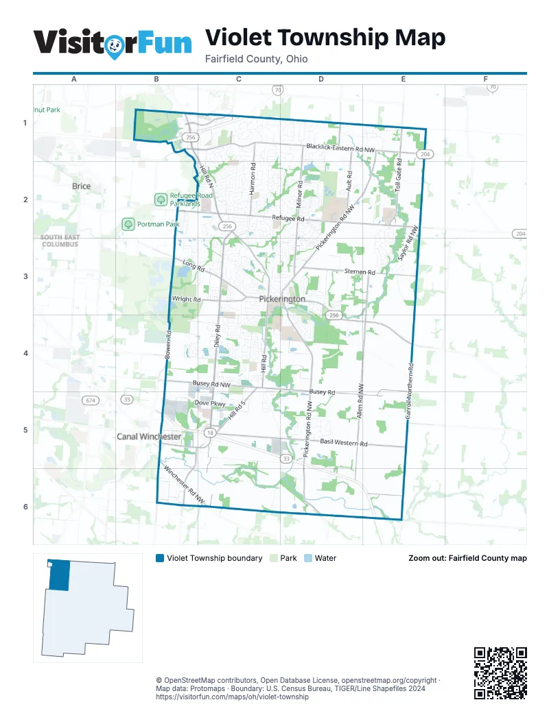
Street index of Violet Township
Each street on the sheet and the grid squares it crosses.
- Columbus-Lancaster Road NorthwestB5, C5, D5, D6, E6
- Diley RoadC2, C3, C4, C5, C6
- Pickerington Road NorthwestE1, D2, E2, D3, D4, D5, D6
- Refugee RoadB2, C2, D2, E2
- Hill Road NorthB1, C1, C2, C3
- Reynoldsburg Baltimore Road NorthwestD3, D4, E4
- Waterloo Road NorthwestB5, B6
- West Columbus StreetC3, D3
- East Columbus StreetD3, B5
- Hill Road NorthwestB5, C5
- Diley Road NorthwestC5, C6
- Baltimore-Reynoldsburg RoadB1
- Kings CrossingC5
- Southeast ExpresswayB5
- Blacklick-Eastern Road NorthwestB1, C1, D1, E1
- Milnor RoadD1, D2, D3
- Hill Road SouthC3, C4, C5
- Busey Road NorthwestB4, C4
- Long RoadB3, C3
- Harmon RoadC1, C2
- Winchester Road NorthwestB5, B6
- Taylor Road SouthwestB1, C1
- Wright RoadB3, C3
- Hill RoadC4
- Lockville RoadD3, D4, D6
- North Center StreetD3
- Taylor RoadC1
- Wagram Road NorthwestD1
- Tussing RoadB1
- East Waterloo StreetB5
- Mink Street SouthwestD1
- Basil Western Road NorthwestE5
- Allen Road NorthwestE3, D4, E4, D5, D6, E6
- Basil Western RoadC5, D5, E5
- Busey RoadB4, C4, D4, E4, D5, E5
- Carroll Northern RoadE4, E5, E6
- Stemen RoadD3, E3
- Toll Gate RoadE1, E2
- Ault RoadD1, D2
- Lithopolis Winchester RoadB5, B6
- Bowen RoadB4
- Lithopolis Winchester Road NorthwestB6
- Lehman RoadB4
- Tollgate Road SouthwestE1
- Amanda Northern Road NorthwestC5, D5, C6, D6
- Sycamore Creek StreetC4
- Stonecreek DriveC2
- Waterloo-Eastern Road NorthwestC5, D5
- Saylor Road NorthwestE2, E3
- Schoolhouse Road NorthwestC3, B4, C4
- Huntington Way NorthwestE2, E3
- Bentwood Farms DriveC2
- Courtright DriveC3, D3
- Doty Road NorthwestE3, E4
- Stonehenge Circle NorthwestD1
- Chateau DriveC2, D2
- Optimara DriveD1, E1
- Coventry AvenueC1, C2
- Fox Glen Drive EastC4
- Circle Drive SouthC2
- Brevard CircleC4
- McLeod ParcC2, C3
- Gray DriveC2
- Melrose BoulevardC2
- Opportunity WayC4, D4
- Dove ParkwayB5, C5
- Stonebridge BoulevardC3, C4
- Lockville Road NorthwestD6, E6
- Windmiller DriveC2
- Fullers CircleB2
- Preston Trails DriveC4
- Tyler AvenueB1, C1, B2, C2
- Pickering DriveD4
- Haaf Farm Drive NorthwestC1
- Yale CircleC4
- Fairfield DriveC4
- Greengate BoulevardC5
- Spring Mill Drive NorthwestD5
- Evergreen CircleC3
- Achievement WayD2
- Rambling Brook DriveC4
- Oakmere DriveC1, C2
- Tributary LaneC1
- Sycamore DriveD4
- Meadows BoulevardC3, D3
- Meadowmoore BoulevardD1
- Oxford DriveC2
- Thorn LaneD5, D6
- Silverbrook DriveC1, C2
- Zeller CircleC4
- Carriage Lane NorthwestC1, D1
- Courtland LaneC3
- Colony Park DriveC3
- Timber Ridge DriveD3
- Balsam DriveC4
- Pruden DriveC3
- Forest Lane Avenue NorthwestE3
- Indian Mound Road NorthwestC1, D1
- Chevington Chase DriveD1, C2, D2
- Autumn Ridge CircleC4
- Lorraine BoulevardC3, C4
- Jefferson Drive NorthwestD5
- Meadow Wood Drive NorthwestC2
- Hounsdale DriveC2
- Flat River StreetC4
- Rustic DriveC1, C2
- Nantucket Avenue NorthwestD1
- Taylors WayD2
- Willow Run DriveC3
- Cosimo Lane NorthwestE1
- Kramer StreetB5
- Delong StreetC2, C3
- Winding Creek WayD2
- Blacklick Woods ParkB1
- Grant Lane NorthwestD3
- Shade DriveC5
- Hampton DriveD3
- Gundy DriveB5
- Blue Jacket CircleD3
- Benadum Road NorthwestD6
- Brook Forest CircleC2, D2
- Springcreek DriveD2
- Church View DriveD1
- Mamie Drive NorthwestE2
- Arlington DriveD3
- Chesapeake WayD2
- Woodstream DriveC4, C5
- Raab StreetC4
- Shady Maple DriveC5
- Eastchester RoadC2
- Village Way DriveD2
- Mackenzie DriveD3, D4
- Rapala LaneD2
- Ebright LaneD2
- Mottlestone Drive NorthwestC1
- Longleaf StreetB4, C4
- Brighton StreetC4
- Timberbank CircleC1
- Lakes Edge WayC3
- Ravine DriveC2, D2
- Fox Glen DriveC4
- Manchester DriveC3
- Raintree AvenueD2
- Wagonwood Drive NorthwestC1
- Ashley Creek DriveC1, C2
- Kelburn LaneD3
- Balderson DriveB3
- Washington StreetB2, C3
- Pickerington Ridge DriveB2
- Linden CircleB4
- Alliston DriveC2
- Camelot Street NorthwestC1
- Sheffield DriveD1, D2
- Seven Pines DriveC3
- Violet Meadows BoulevardE1
- Easton DriveC2, D2
- Pickerington Hills DriveD4
- Woodsfield Circle WestC2
- Lilac CircleC3
- Park AlleyC3, D3
- South Crosset Hill DriveC1, C2
- Chanticleer Drive NorthwestD2
- Fox Run Street NorthwestD2, E2
- Windridge Drive NorthwestE3
- Laurelwood Drive NorthwestD5
- Olde Post Road NorthwestD1
- Shalemar Drive NorthwestC2
- Town Square DriveC3, D3
- Wayside Drive NorthwestD1
- Oakshire DriveC2, D2
- Leasure DriveB3, C3
- Granden StreetC2
- North East StreetD3
- Wellesley DriveC1
- Kingfisher LaneD2
- Durham CircleC1
- Hilltop DriveD4
- Wooster StreetC4
- Appleridge Circle NorthwestD2
- Bridgewater Drive NorthwestD2
- North Starr DriveC3
- Peggy Green LaneC3, D3
- Brandon CircleC1, C2
- Postage CircleC2
- Howe Industrial ParkwayB5, C5
- Carver StreetC4
- Northchester DriveC2
- Cobblestone Lane NorthwestD1
- Longview StreetD3
- Falmouth AvenueC1
- Birchwood StreetC2
- Wheaton DriveC2
- Morningview AvenueD4
- Sudbury DriveD1
- Pioneer CircleC3
- Milford DriveC2
- Bainwick Drive NorthwestC1
- Merry Lane NorthwestC2
- Sheryl DriveC3
- Herrogate SquareC4
- Florence DriveC3
- Pleasant View DriveD2
- Georges Creek DriveC3
- Summerfield WayC1, C2
- Westbury DriveC3, D3
- Ashford Lane NorthwestD2
- Silver Springs Street NorthwestD5
- Olde Mound LaneD3
- Cherry Hill DriveC3
- Saratoga LaneC2
- North Crosset Hill DriveC1
- Parkwood AvenueC3
- Dunvegan CircleC2, C3
- Brookside DriveC2, C3
- Capetown AvenueC1
- Turnberry DriveB1, B2, C2
- Carrowmoore DriveB3
- Grandview AvenueC2
- Cross Creeks BoulevardC2
- Eddington AvenueC2
- Riverton Circle NorthwestE2, E3
- Melody LaneC2
- Sunladen Drive NorthwestC1
- Daventry Drive NorthwestD2, D3
- East Hocking StreetB5
- Tranquil TrlD5
- Montmorency Drive SouthC3
- Glenwood Avenue NorthwestD5
- Butterfield DriveC2
- Taylor Park DriveB1
- Woodsfield Circle SouthC2
- Garden DriveD1, D2
- Ra-mar DriveD4
- Rooster Tail DriveD2
- Great Trail StreetB2
- Pearl LaneC3
- Yarmouth RoadC1
- Steeplechase Avenue NorthwestC2
- Prairie View Drive NorthwestE2
- Winston RoadC1, D1
- Thoroughbred Drive NorthwestC2
- Willard DriveD3
- Finch LaneC4, C5
- Hayden Avenue NorthwestD1, D2
- Salisbury StreetC4
- Treemoss StreetB2
- Streamside DriveD2
- Old Diley RoadC2
- Old Gate Drive NorthwestC1
- Appleton DriveD1, D2
- Heatherwood Drive NorthwestD5
- Walnut Street NorthwestD6
- Wesley WayB1
- Kennington Square NorthE2
- Montmorency Drive EastC3
- Meijer DriveC5
- Fox Run Court N WestD2
- Monarch StreetB5
- Wharncliff LoopD3
- Meadowcroft Street NorthwestE3
- Fuller's WayB2
- Gearied Street NorthwestD1, D2
- Lorriane DriveC3
- Comstock Terrace NorthwestD3
- Lillian DriveC4
- Glencrest DriveD3
- Westfall CircleC2
- Selkirk WayC2
- Hereford DriveD4
- Commerce DriveC3
- Greenwood DriveD2
- Knightsbridge Drive NorthC3
- West Church StreetC3, D3
- Alexander Lawrence DriveC3
- Grinnell StreetC4
- Thrush CircleC4
- Crestwock CourtB3
- Carron CircleC2
- Kaye DriveC3
- Crawford DriveC2
- Teal LaneC2
- Bluffton Drive NorthwestD2, D3
- Bridgeview Drive NorthwestE3
- Larkspur WayC3
- Badger DriveB5
- Morgan StreetC2
- Shawnee DriveD3
- Streamside RoadB3
- Cumberland Circle NorthwestD5
- Daysprings Way NorthwestC1
- Ludham TrailC3, D3
- Marie LaneC3
- Violet Drive WestC3
- Taylor Court NorthwestC2
- Freedom Way NorthC1
- Durand StreetB4, C4
- Night Heron LaneD2
- Bluebird LaneC5
- Canteridge DriveC4
- Albion StreetC4
Places on the map
- 33 Self Storage
- Amtrec Business Center
- Bakers Landscapers
- Blacklick Woods Metro Park
- Board of Trustees Administrative Office
- Brandt Family Farm
- Busey Road Park
- City Of Pickerington Park And Recreation Department
- Diley Middle School
- Diley Ridge Medical Center
- Donley Lake
- Dovel Memorial Cemetery
- Ellis Pond
- Fairfield Elementary School
- Glenshire Reserve
- Harmon Middle School
- Huntington Hill Recreation
- McGill Pond
- Meijer
- OhioHealth Pickerington Methodist Hospital
- Pickerington
- Pickerington Area Soccer Association
- Pickerington Central Junior High School
- Pickerington Elementary School
- Pickerington High School Central
- Pickerington High School North
- Pickerington Lakeview Junior High School
- Pickerington Public Libary: Sycamore Plaza
- Pickerington Youth Athletic Association
- Pintail Marsh
- Preston Trails Park
- Refugee Road Medical Corridor
- Sam's Club
- Shoff Door Company
- Simsbury Disc Golf Course
- Simsbury Park
- St. Elizabeth Ann Seton Parish
- Sycamore Creek Elementary
- Sycamore Creek Park
- Zeller Soccer Park
Next to Violet Township
- Brice
- Canal Winchester
- South East Columbus
© OpenStreetMap contributors, Open Database License, openstreetmap.org/copyright · Map data: Protomaps · Boundary: U.S. Census Bureau, TIGER/Line Shapefiles 2024















