

Oklahoma map
Duncan map
About 23,174 people live here (Census Bureau, 2024 estimate). The sheet's index lists 300 streets; West Gatlin Road, Duncan Bypass and Country Club Road cross the most grid squares. Things to do inside the boundary: Chisholm Trail Casino and Chisholm Trail Heritage Center.
Open the map (PDF, US Letter)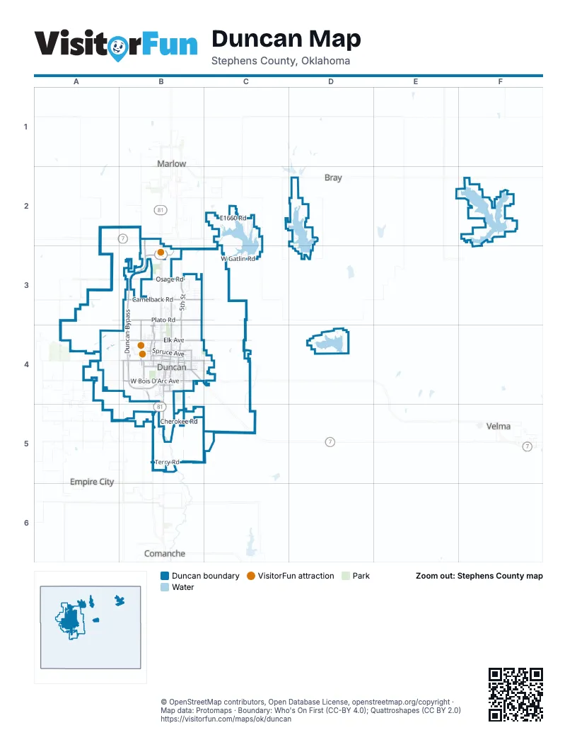
Street index of Duncan
Each street on the sheet and the grid squares it crosses.
- Duncan BypassB2, B3, B4
- West Elk AvenueB4
- West Beech AvenueB4
- West Main StreetB4
- Country Club RoadB3, B4
- West Plato RoadB3
- North 10th StreetB4
- Chisholm Trail ParkwayB4
- Ridley RoadB4
- East Main StreetB4
- Eastland DriveB4
- North 5th StreetB3, B4
- West Bois D'Arc AvenueB4
- West Camelback RoadA3, B3
- West Osage RoadA3, B3
- Plato RoadA3, B3
- South 2nd StreetB4, B5
- West Spruce AvenueB4
- West Seminole RoadB4
- Old US Highway 81B5
- South 13th StreetB4, B5
- North 29th StreetB3, B4
- Boren BoulevardB3
- West Pine AvenueB4
- South 42nd StreetB4, B5
- East Chestnut AvenueB4, C4
- East Elk AvenueB4, C4
- East Camelback RoadB3
- West Elder AvenueB4
- West Chestnut AvenueB4
- North 20th StreetB4
- South 9th StreetB4
- Bois D'Arc AvenueB4, C4
- North 15th StreetB3, B4
- East Plato RoadB3, C3
- North 27th StreetB4
- M L King Jr AvenueB4
- North D StreetB4
- South 12th StreetB4
- North 2nd StreetB4
- North Overland DriveB4
- North Whisenant DriveB4
- West Park AvenueB4
- South Eastland DriveB4
- North Eastland DriveB4
- Forest Hills DriveB4
- North 42nd StreetB4
- North Timbergate RoadB3, B4
- Cemetery RoadC4, B5
- High Meadow DriveB4
- Fowler DriveB4
- West Gatlin RoadA3, B3, C3, D3
- North North StreetB3, B4
- Cherokee RoadB5, C5
- E1660 RoadC2, F2
- Area DC2
- West Oak AvenueB4
- West Walnut AvenueB4
- D2895 RoadD2
- King RoadC2, D2
- North 13th StreetB4
- North 7th StreetB3, B4
- North 6th StreetB3, B4
- Clearcreek RoadD2, D3
- West Cedar AvenueB4
- Duncan Lake RoadD4
- West Ash AvenueB4
- West Willow AvenueB4
- North 12th StreetB4
- North 11th StreetB4
- West Hickory AvenueB4
- West Maple AvenueB4
- South 27th StreetB4
- North 19th StreetB4
- South 10th StreetB4
- West Elm AvenueB4
- South 58th StreetA4, A5
- Oklahoma Hills RoadB5
- East Terry RoadB5, C5
- East Willow AvenueB4, C4
- West Cypress AvenueB4
- West Sycamore AvenueB4
- Terry RoadB5
- 42nd StreetB3, B4
- South 8th StreetB4
- West Pecan AvenueB4
- E1665 RoadF2
- Elk AvenueA4, B4
- South 11th StreetB4
- North 21st StreetB4
- North 44th StreetB4
- 96th StreetA3, A4
- Beech AvenueA4, B4
- Fuqua Lake RoadF2
- North 8th StreetB4
- Bois D'ArcA4, B4
- North 9th StreetB4
- Area AC2
- North B StreetB4
- West Mulberry AvenueB4
- North C StreetB4
- East Beech AvenueB4, C4
- South 7th StreetB4
- N2840 RoadB5
- Area B-W Horsetooth RoadC2
- North 14th StreetB4
- Lake RoadD2, C5
- E1715 RoadD4
- Concession Stand RoadC2
- 92nd StreetA3, A4
- South 4th StreetB4
- South 3rd StreetB4
- Osage RoadB3, C3
- South Shore DriveC3
- East Osage RoadB3
- Campground RoadD2, D3
- North 3rd StreetB4
- West Hackberry AvenueB4
- West Jones AvenueB4
- South 14th StreetB4
- South 15th StreetB4
- West Chisholm DriveB4
- North 1st StreetB4
- South King PlaceB4
- McCurdy RoadB3
- East Ash AvenueB4, C4
- North I StreetB4
- Renfrow RoadD2
- Camelback RoadC3
- Walnut Hill DriveB3
- South 6th StreetB4
- South 5th StreetB4
- North Alice DriveB4
- South C StreetB4
- North 18th StreetB4
- Area EastC2
- Odom DriveB3
- West Randall AvenueB4
- West Stephens AvenueB4
- North E StreetB4
- North A StreetB4
- Day StreetB3
- North Harville RoadB4
- West Parkview AvenueB4
- North Grand BoulevardB4
- Ponderosa RoadB3
- Whaley DriveC3
- North F StreetB4
- Mc Casland ParkwayB4
- West Magnolia AvenueB4
- Copperwood StreetB3
- West Club RoadB3, B4
- West Peach AvenueB4
- West Duncan AvenueB4
- Lakefront RoadD2
- North G StreetB4
- North 4th StreetB4
- Brookline DriveB4
- Fuller RoadB5
- 58th StreetA4
- Stage Stand RoadB3
- Blackjack LaneB3
- Fir AvenueB4
- EkowahF2
- Drexal PlaceB4
- Terrace DriveB4
- West Birch AvenueB4
- North 17th StreetB4
- Quail DriveB3
- Wildwood PlaceB3
- N2835 RoadB4
- East Elm AvenueB4
- West Mallard DriveB4
- North Northridge DriveB4
- Glen BoulevardB4
- South 1st StreetB4
- Normandy RoadB4
- East Walnut AvenueB4
- El Rancho DriveB3
- West Woodlawn AvenueB4
- Pearl StreetB4
- Lakewood BoulevardB4
- Woodside DriveB3
- Timber Ridge DriveB3
- Clayton AvenueB4
- N2790 RoadA2
- Twisted Oaks DriveB3
- South Viola StreetB4
- North J StreetB4
- South Industrial AvenueB4
- Nickles RoadB3
- North H StreetB4
- Ridgecrest DriveB4
- Springdale LaneB3
- West Scott LaneB4
- East Maple AvenueB4
- West Windsor DriveB4
- West Louis AvenueB4
- Heffington RoadB2
- Paloma DriveB4
- Twin DriveB3, B4
- North 28th StreetB4
- Archway StreetB4
- N2850 RoadC5
- West Mockingbird LaneB4
- East Mosley DriveB4, C4
- Village DriveB4
- West Holly AvenueB4
- West Redbud AvenueB4
- West Jefferson AvenueB4
- West Peck AvenueB4
- Duncan Regional LoopB4
- Cabinsite RoadD2, D3
- East Pine AvenueB4
- Westview RoadB4
- Timbercreek DriveB3
- Bible WayB4
- Lizabeth DriveB4
- Palm AvenueB4
- Wild Oaks DriveB3
- Elsworth LaneB3
- Palm DriveB3, B4
- Green Meadow DriveB4
- Cherry AvenueB4
- Country LaneB3
- Bent Tree StreetB3
- East Oak AvenueB4
- Lester BoulevardB4
- Demolay AvenueB4
- Northridge DriveB3, B4
- Sunset DriveB3, B4
- Kristin LaneB3
- West Waverly DriveB4
- 60th StreetA3
- Oakridge DriveB3
- WillowridgeB3
- Clampitt DriveB3
- Amanda DriveB4
- Shady Oaks LaneD4
- Westside DriveB4
- Twilight Beach RoadB3
- Clear Springs DriveB3
- N2830 RoadB5
- West Washington AvenueB4
- Whispering Hills DriveB3
- West Cook StreetB4
- South 19th StreetB4
- Woodcrest DriveB3
- E1670 RoadF2
- 29th StreetB3, B4
- North 31st StreetB4
- Alpine DriveB4
- North 30th StreetB4
- AshlandB3
- West Meadow Lark AvenueB4
- Marvin DriveB4
- BriarcrestB3
- East Mulberry AvenueB4
- South B StreetB4
- South A StreetB4
- Blue Chip RoadB5
- Hillcrest DriveB4
- Oak Hollow RoadB3
- Ben RoadC2
- Jacquelyn TerraceB3
- Eastwood DriveC4
- North K StreetB4
- Carriage DriveB4
- North Primrose StreetB4
- Hidden OakB3
- Nix RoadB3
- West Apollo DriveB4
- Crescent DriveB4
- Sharp AvenueB4
- Carver AvenueB4
- Wilshire DriveB4
- West Fuller RoadB5
- Crestline DriveB3
- Westbriar RoadB4
- Stoneridge LaneB3
- Woodrock DriveB4
- North L StreetB4
- Flamingo LaneB4
- Canterbury LaneB3
- MillrunB3
- Allen StreetB3
- Horsetook RoadC2
- Homesite RoadD2
- N2990 RoadF2
- Crestmont DriveB3
- WoodknollB3
- Poplar AvenueB4
- Daryl PlaceB3
- Emery RoadB4
- East Garrison RoadC2
- Cox StreetB3
- Northgate AvenueB3
- Country Club TerraceB3, B4
- Cardinal AvenueB4
- 27th StreetB5
Things to do on the Duncan map
Places on the map
- Abe Raizen Park
- Ace Hardware
- All Saints Episcopal Church
- Applebee's
- Assumption of the Blessed Virgin Mary Catholic Church
- Bear Creek Cemetery
- Braum's Ice Cream & Dairy Store
- Chicken Express
- Chisholm Mall
- Chisholm Trail Casino
- Chislohm Trail Heritage Center
- Clear Creek Lake
- Copland Airport
- Don Grantham's Funeral Home
- Duncan Cemetery
- Duncan Golf and Tennis Club
- Duncan High School
- Duncan High School Track
- Duncan Public Library
- Duncan Regional Hospital
- Fairfield Inn
- Fuqua Park
- Halliburton Field
- Halliburton Stadium
- Hampton Inn Duncan
- Henderson-Harris Cemetery
- Heritage Park Arboretum
- Hillcrest Park
- Hines Softball Park
- Holiday Inn Express & Suites
- Homeland
- Jimmy's Egg
- Lake Duncan
- Lake Fuqua
- Lake Humphreys
- Love's
- Mann School
- Mark Twain School
- Twin Oaks Golf Club
- Wisenant Park
Next to Duncan
- Bray
- Comanche
- Empire City
- Marlow
- Velma
© OpenStreetMap contributors, Open Database License, openstreetmap.org/copyright · Map data: Protomaps · Boundary: Who's On First (CC-BY 4.0); Quattroshapes (CC BY 2.0)















