

Oklahoma map
Enid map
About 50,519 people live here (Census Bureau, 2024 estimate). The sheet's index lists 300 streets; East Owen K. Garriott Road, South Van Buren Street and East Willow Road cross the most grid squares. Things to do inside the boundary: Cherokee Strip Regional Heritage Center.
Open the map (PDF, US Letter)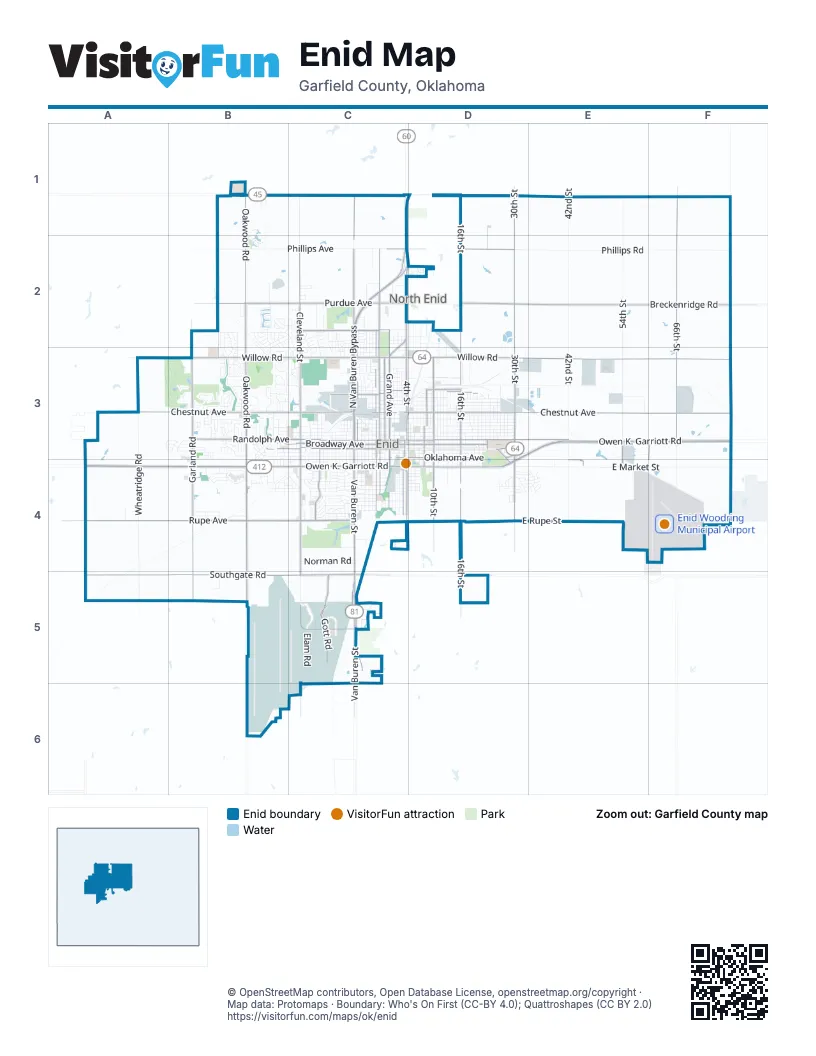
Street index of Enid
Each street on the sheet and the grid squares it crosses.
- East Owen K. Garriott RoadD3, E3, F3, C4, D4
- West Owen K. Garriott RoadA4, B4, C4
- North Van Buren StreetC1, C2, C3
- South Van Buren StreetC3, C4, C5, C6
- East Willow RoadC3, D3, E3, F3
- North Van Buren BypassC2, C3
- North 30th StreetD1, D2, D3
- North 66th StreetF1, F2, F3
- North 4th StreetC2, D2, C3, D3
- South 30th StreetD3, D4
- East Oklahoma AvenueC3, D3, E4
- East Phillips AvenueC2, D2
- Wheat Capital RoadC6
- West Fox DriveC5
- Kremlin StreetF3, F4
- Gray Ridge RoadC5
- West Willow RoadA3, B3, C3
- North Grand AvenueC2, C3
- West Maine StreetB3, C3
- West Broadway AvenueB3, C3
- East Broadway AvenueC3, D3
- South Grand AvenueC3, C4
- Rock Island BoulevardC2, C3
- West Carrier RoadB1
- University BoulevardD3, D4
- East Maine StreetC3, D3
- East Chestnut AvenueC3, D3, E3, F3
- West Southgate RoadA5, B5, C5
- West Rupe AvenueA4, B4, C4
- North Oakwood RoadB1, B2, B3
- West Chestnut AvenueA3, B3, C3
- North 16th StreetD1, D2, D3
- Breckenridge RoadD2, E2, F2
- North Cleveland StreetC2, C3
- West Randolph AvenueB3, C3
- North Washington StreetC2, C3
- East Randolph AvenueC3, D3, E3
- West Purdue AvenueB2, C2
- South Oakwood RoadB3, B4, B5
- South 16th StreetD3, D4, D5
- South Cleveland StreetC3, C4, C5, C6
- South Garland RoadB3, B4, B5
- North Garland RoadB3
- Gott RoadC5
- West Oxford AvenueC2
- North 10th StreetD3
- North Independence AvenueC3
- North Adams StreetC2, C3
- Leona Mitchell BoulevardC4
- South Johnson StreetC3, C4
- South 10th StreetD3, D4
- South 4th StreetC3, C4
- South Adams StreetC3, C4
- Breckinridge RoadD2
- North 8th StreetD3
- North Jackson StreetC2, C3
- West Poplar AvenueC3
- East Cherry AvenueC3, D3
- South Washington StreetC3, C4
- Kincade RoadC5
- East Peach AvenueD3
- South 8th StreetD3, D4
- East Southgate RoadD5
- East Purdue AvenueC2
- Raleigh StreetE3, E4
- South 54th StreetE4
- North University AvenueD3
- South University AvenueD3
- North 42nd StreetE1, E2, E3
- North 54th StreetE1, E2, E3
- East Market StreetD4, E4, F4
- Phillips RoadD2, E2, F2
- West Phillips AvenueB2, C2
- South Wheatridge RoadA3, A4, A5
- West Cherokee AvenueB3, C3
- West Oklahoma AvenueB3, C3
- East Elm AvenueC3, D3
- East Walnut AvenueC3, D3
- East Maple AvenueC3, D3
- East Ash AvenueC3, D3
- East Pine AvenueC3, D3
- South 42nd StreetE3, E4
- West Elm AvenueB3, C3
- North Monroe StreetC2, C3
- Indian DriveB4, C4
- North Jefferson StreetC2, C3
- East Oak AvenueC3, D3
- East Cherokee AvenueC3, D3
- West Walnut AvenueB3, C3
- West Maple AvenueC3
- North Quincy StreetC2, C3
- East Birch AvenueC3, D3
- East Park AvenueD3, C4, D4
- West Pine AvenueB3, C3
- North 3rd StreetC2, C3
- North 2nd StreetC2, C3
- East Cedar AvenueC3, D3
- North 11th StreetD2, D3
- South Monroe StreetC3, C4
- South Hayes StreetC3, C4
- South 3rd StreetC3, C4
- North 5th StreetD2, D3
- North 13th StreetD2, D3
- North 6th StreetD2, D3
- West Oak AvenueB3, C3
- South Jefferson StreetC3, C4
- North Wheatridge RoadA3
- North 7th StreetD2, D3
- West Thompson AvenueC4
- North Madison StreetC2, C3
- East Locust AvenueD3
- South Independence AvenueC3, C4
- West Park AvenueC4
- Rockwood RoadB2, B3
- East Cypress AvenueD3
- Whippoorwill LaneB2, C2, C3
- North Grant StreetC2, C3
- Oakwood MillB4
- South 2nd StreetC3, C4
- Constitution AvenueB2, B3
- North 12th StreetD3
- Cleveland StreetC1, C2
- East Rupe StreetD4, E4
- East Eucalyptus AvenueD3
- Norman RoadC4
- Richland AvenueC4
- Mount Vernon RoadB2, B3
- South Madison StreetC3, C4
- South Jackson StreetC3, C4
- North 14th StreetD3
- Memorial DriveC1, C2
- North Lincoln StreetC2, C3
- North 26th StreetD3
- West Wabash AvenueC4
- West Ritchie AvenueB4
- North 9th StreetD3
- Rolling Oaks DriveB3, C3
- West Mulberry AvenueC3
- South Hoover StreetB3, B4
- South Taylor StreetC3, C4, C5
- Jerauld Gentry RoadE4, F4
- South Quincy StreetC3, C4
- North 19th StreetD3
- Quailwood DriveB3
- North Davis StreetD3
- North 21st StreetD3
- South 66th StreetF3, F4
- Seneca AvenueC4
- West York AvenueC4
- Deerfield AvenueB3
- West Cherry AvenueC3
- South 13th StreetD3, D4
- Ramona DriveC4
- Hillcrest DriveD4, E4
- South 5th StreetD3, D4
- North 23rd StreetD3
- Elam RoadC5
- Sunnybrook LaneB4, C4
- North Pierce StreetC2, C3
- North 15th StreetD3
- North Johnson StreetC3
- North 20th StreetD3
- Sooner TrendE3
- East Cornell AvenueC2, D2
- Kenwood BoulevardC3
- South 7th StreetD3, D4
- North Polk StreetC3
- South 9th StreetD3, D4
- Forestridge DriveD4
- North 22nd StreetD3
- Brown ParkwayC5
- East Princeton AvenueC2, D2
- Rupe DriveE4
- West Birch AvenueC3
- Oakcrest AvenueB3
- South 6th StreetD3, D4
- Falcon Crest DriveB2
- North Kennedy StreetC3
- North Meadowbrook DriveC3
- Woodlands DriveB3
- Edgewood DriveB2, C2, B3
- West James AvenueC3
- Willow Lake LaneB2
- Wagon TrailC2, C3
- West Illinois AvenueC4
- West Spruce AvenueC3
- Ponca AvenueC4
- North Coolidge StreetB3
- West Iowa AvenueC4
- Quail Creek DriveB3
- North 25th StreetD3
- East Ohio AvenueC4, D4
- East Hemlock AvenueC3, D3
- Sequoyah DriveC4
- Woodring ParkwayC5
- Cedar Ridge DriveA3, B3
- South la Mesa DriveB3
- Liberty LaneB2, B3
- Custer DriveC2
- East Wabash AvenueC4, D4
- Quail Ridge RoadB3
- East Indiana AvenueC4, D4
- Hite BoulevardC4
- Wilkie WayC5
- North Central StreetD3
- North Eisenhower StreetB3
- Deer RunB3
- Scott DriveC5
- West Moore AvenueC4
- Evandale DriveB4
- East Rupe RoadD4
- North Emerson StreetD2, D3
- North Tyler StreetC3
- West State AvenueC4
- South Tyler StreetC3, C4
- Franklin DriveB2, B3
- Old Mallard RoadB2
- Pride DriveC5
- West Indiana AvenueC4
- Kelly RoadB2, C2
- Cansler DriveB3
- West Palm StreetC3
- West Frantz AvenueC4
- West Nagel AvenueC4
- West Rush AvenueC4
- East Illinois AvenueC4, D4
- North 18th StreetD3
- Heritage TrailC2, C3
- Oakdale DriveB3
- North 27th StreetD3
- West Yale AvenueC3
- Pawnee StreetC4
- Sandy DriveB1, B2
- West Ash AvenueC3
- West Hackberry AvenueC3
- East York AvenueC4, D4
- East Harvard StreetC3, D3
- West Locust AvenueC3
- Westwood RoadB3
- East Iowa AvenueC4, D4
- Rose Tree LaneB3
- Cheyenne DriveC4
- N2845 RoadB5
- Hunters Hill DriveC3
- North 24th StreetD3
- North 28th StreetD3
- Redbird LaneB2, B3, C3
- East State AvenueC4, D4
- Robin RidgeB4, C4
- Pheasant Run DriveB3
- ClairemontB2, C2
- Edwards StreetC5
- Wynona AvenueC4
- BluebellB1, B2
- Sunridge RoadC5
- Homestead RoadC2, C3
- South 12th StreetD3, D4
- Midway StreetC2, C3
- South 14th StreetD3, D4
- South 15th StreetD3, D4
- South 11th StreetD3, D4
- South Grant StreetC3, C4
- South Lincoln StreetC3, C4
- Barn Swallow RoadB2
- South Buchanan StreetC3, C4
- South Pierce StreetC3, C4
- Briar Ridge RoadB3
- South Fillmore StreetC3, C4
- East Poplar AvenueC3, D3
- South Polk StreetC3, C4
- Shady LaneC2
- South Harrison StreetC3, C4
- Lisa LaneB3
- Denim LaneC2
- Country Club DriveB3
- Oakridge RoadB3, C3
- McClaflin DriveE4
- Comanche TrailC4
- Hereford DriveA4
- Maple Leaf CircleB3
- Canary LaneB4, C4
- East Cambridge AvenueC2, D2
- North Harding StreetB3
- Lookout DriveD4, E4
- South 20th StreetD3, D4
- East 2nd Pine AvenueD3
- Young RoadC5
- East Hackberry AvenueC3, D3
- Gannon AvenueC4
- North Taft StreetB3
- Rosanne StreetB3
- Wildwood DriveB2, C2, C3
- Nottingham DriveB3
- Hurst DriveC5
- Unruh DriveB2
- Mill RunB4
- FairviewC2, C3
- North 17th StreetD3
- Airport RoadF4
- Hancock AvenueB3, C5
Things to do on the Enid map
Places on the map
- 4R Kids Mini Golf Course
- Abundant Life Temple Church
- Adams Elementary School
- Advance Soccer Complex
- Adventure Quest
- ALDI
- Americas Best Value Inn
- Assembly of God Church Evangeletical
- Astros' Ballpark
- Baptist Village Golf Course
- Baptist Village Pond
- Chisholm High School
- Chisholm Trail Expo Center
- Crosslin Park
- Crosslin Pond
- Enid Cemetery
- Enid Senior High School
- Enid Soccer Complex
- Enid Speedway
- Enid Woodring Municipal Airport
- Government Springs Park
- Government Springs Park (South)
- INTEGRIS Health Enid Hospital
- Kellet Softball Park
- Love's Travel Stop
- Meadow Lake Golf Course
- Meadow Lake Park
- Northern Hills Golf Course
- Oakwood Country Club Golf Course
- Oakwood Mall
- Oakwood Mill
- Pheasant Run Golf Course
- Prairie View Elementary School
- Sunset Plaza
- The Mailroom Neighborhood Postal Center
- Vance Air Force Base
- Vance Park
- Waller Middle School
- Walmart Supercenter
- Willow Lake
Next to Enid
- North Enid
© OpenStreetMap contributors, Open Database License, openstreetmap.org/copyright · Map data: Protomaps · Boundary: Who's On First (CC-BY 4.0); Quattroshapes (CC BY 2.0)















