

Oklahoma map
Garfield County map
About 62,007 people live here (Census Bureau, 2024 estimate). The sheet's index lists 300 streets; Main Street, County Line Road and E0510 Road cross the most grid squares. Things to do inside the boundary: Cherokee Strip Regional Heritage Center and Enid.
Open the map (PDF, US Letter)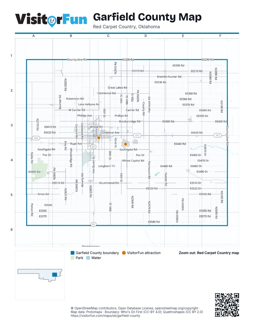
Maps inside Garfield County
1 map inside, from the street map of Garfield County down.
Street index of Garfield County
Each street on the sheet and the grid squares it crosses.
- County Line RoadA1, B1, C1, E1, E2, F2, E3, F3, F4, F5
- Trooper Chris Van Krevelen Memorial HighwayA3, B3, D3, E3
- Hunter RoadE3, E4, E5, E6
- South 30th StreetC3, C4, C5, C6
- Staff Sargeant Chris Hake Memorial HighwayC1, C2, C3
- Norma A. Lamb HighwayE3, F3
- North 66th StreetC1, C2, C3
- North 78th StreetD1, D2, D3
- South Van Buren StreetC3, C4, C5
- East Owen K. Garriott RoadC3, D3
- West Fox DriveA4, B4, C4
- East Centennial RoadC2, D2
- North 30th StreetC2, C3
- West Owen K. Garriott RoadB3, C3
- West Carrier RoadB3, C3
- North Van Buren StreetC3
- East Willow RoadC3, D3
- North Van Buren BypassC3
- Drummond RoadC5
- North 4th StreetC3
- N2870 RoadC2, C3, C4, C5
- East Phillips AvenueC3
- East Oklahoma AvenueC3
- Wheat Capital RoadB4, C4
- Kremlin StreetC3
- Gray Ridge RoadC4
- Lahoma RoadA3
- Hare MahafferyD3
- West Willow RoadB3, C3
- North Grand AvenueC3
- West Maine StreetB3, C3
- West Broadway AvenueB1, B3, C3
- Maple StreetA2, B2
- East Broadway AvenueC3
- 1st StreetC2, A3, E4, C5, C6
- Kansas AvenueB3, C3, A4
- South Grand AvenueC3
- Broadway StreetA2, A4, F5
- Rock Island BoulevardC3
- University BoulevardC3
- East Maine StreetC3
- North Portland AvenueE6
- Kremlin-Hunter RoadC2, D2, E2, F2
- E0510 RoadA5, B5, C5, D5, E5, F5
- E0310 RoadC1, D1, E1, F1
- E0400 RoadA3, D3, E3, F3
- E0520 RoadA5, B5, D5, E5, F5
- Fairmont RoadD1, D2, D3, D4
- North 54th StreetC1, C2, C3
- North 16th StreetC1, C2, C3
- Stabe RoadA3, A4, A5
- N2820 RoadB2, B4, B5
- East Southgate RoadC4, D4
- E0490 RoadA4, B4, C4, F4
- E0530 RoadA5, B5, E5, F5
- Breckenridge RoadC3, D3, E3
- North Oakwood RoadB2, B3
- North Garland RoadB2, B3
- West Rupe AvenueA4, B4, C4
- N2970 RoadD4, D5, D6
- E0520 DriveE5, F5
- West Southgate RoadA4, B4, C4
- West Purdue AvenueB3, C3
- Fairmount RoadD4, D5
- West Chestnut AvenueB3, C3
- South 54th StreetC3, C4, C5
- East Chestnut AvenueC3, D3
- Ames RoadA5, B5
- South Oakwood RoadB3, B4
- South 16th StreetC3, C4
- Beverly RoadB4, B5
- Main StreetB1, E1, A2, C2, A3, E3, A4, D4, E4, C5, F5, C6
- County RoadC2, D2, D3
- North 102nd StreetD1, D3
- South Cleveland StreetB3, B4
- Leona Mitchell BoulevardC3, C4
- North Cleveland StreetB3
- West Randolph AvenueB3, C3
- North Washington StreetC3
- East Randolph AvenueC3
- South Garland RoadB3, B4
- South 10th StreetC3, C4
- 66th StreetC4
- N2815 RoadB1, B2
- Breckinridge RoadC3
- South 66th StreetC3, C4
- Gott RoadC4
- West Oxford AvenueB3, C3
- North 10th StreetC3
- North Independence AvenueC3
- North Adams StreetC3
- South Johnson StreetB3, C3, B4
- South 4th StreetC3, C4
- Apache StreetC3, E3
- South Adams StreetC3, C4
- North 8th StreetC3
- North Jackson StreetC3
- West Poplar AvenueC3
- Cherokee StreetD1, E1, A4, C5
- East Cherry AvenueC3
- South Washington StreetC3
- Kincade RoadC4
- East Garber RoadE3
- East Euclid AvenueC5
- East Peach AvenueC3
- West Euclid AvenueB5, C5
- South Main StreetB1, B2, C5
- South 8th StreetC3
- Patterson StreetD4
- Diener StreetD5
- West Railroad StreetE3
- East Purdue AvenueC3
- Raleigh StreetC3
- East Railroad StreetE3
- West Taylor AvenueB1
- South AvenueB2
- North University AvenueC3
- South University AvenueC3
- E0300 RoadC1, D1, E1, F1
- E0420 RoadA3, B3, D3, E3, F3
- N2840 RoadB1, B2, C2, B4, B5
- E0440 RoadB4, D4, E4, F4
- Southgate RoadA4, B4, D4, E4, F4
- E0370 RoadD2, E2, F2
- E0360 RoadD2, E2, F2
- East Wheat Capital RoadC4, D4, E4
- E0480 RoadA4, B4, D4, E4, F4
- Carrier RoadC3, D3, E3
- N3100 RoadF1, F2, F3, F5, F6
- E0580 RoadD6, E6, F6
- N2950 RoadD1, D2, D3
- Robertson RoadA2, B2, C2
- E0350 RoadD2, E2, F2
- Lake Hellums RoadB2, C2, D2
- South Wheatridge RoadB3, B4, B5
- Great Lakes RoadC2, D2, E2
- E0330 RoadC2, D2, E2
- N3080 RoadF1, F2, F5, F6
- N3090 RoadF1, F2, F5, F6
- N3030 RoadE1, E2, E5, E6
- E0560 RoadB5, E5, F5
- E0390 RoadA3, B3, E3, F3
- E0290 RoadC1, D1, E1, F1
- West Wheat Capital RoadA4, B4
- North 42nd StreetC2, C3
- Boomer RoadB1, B2, B3
- East Longhorn TrailB4, C4, D4
- South 42nd StreetC3, C4, C5
- Fox DriveC4, D4, E4
- E0570 RoadE6, F6
- Wheatridge RoadB1, B2
- E0380 RoadE3, F3
- E0510 DriveE5, F5
- E0460 DriveE4, F4
- East Robertson RoadC2, D2
- N2770 RoadA3, A4, A5
- E0480 DriveE4, F4
- N2800 RoadB4, B5
- E0470 DriveE4, F4
- N3060 RoadE1, E5, E6
- N2940 RoadD4, D5, D6
- N2860 RoadB1, B2, B4, B5, B6
- E0410 RoadA3, B3
- Imo RoadB2, B3, B4
- N3020 RoadE5, E6
- E0560A5, B5
- E0570A6, B6
- West Phillips AvenueB3, C3
- Patton RoadA5, A6
- East Market StreetC3, D3
- E0550A5, B5
- CR N3010E1, E2
- North Imo RoadB3
- West Longhorn TrailB4
- N2865 RoadC4, C5
- Phillips RoadC3, D3, E3
- E0540A5, B5
- E0490 DriveE4, F4
- North Wheatridge RoadB3
- East Fox DriveC4
- N2770A5, A6
- E0340 RoadE2
- South Boomer RoadB3, B4
- North Boomer RoadB3
- RupeA4
- N3070 DriveF4
- N3050 RoadE5, E6
- 78th StreetD4
- N2910 RoadC1, C2, C6
- E0500 RoadA5
- East 0390 RoadD3, E3
- Cleveland AvenueB2, B3
- South Imo RoadB3, B4
- West Cherokee AvenueB3, C3
- West Oklahoma AvenueB3, C3
- N3070 RoadF5, F6
- East Elm AvenueC3
- East Walnut AvenueC3
- East Maple AvenueC3
- East Ash AvenueC3
- East Pine AvenueC3
- Garland RoadB4
- Michael RoadB3, B4
- E0540 RoadF5
- E0320 RoadA2
- West Elm AvenueB3, C3
- North Monroe StreetC3
- N2960 RoadD5, D6
- Indian DriveB3, C3
- North Jefferson StreetC3
- East Oak AvenueC3
- East Cherokee AvenueC3
- CrestwoodC3
- E0460 RoadA4, F4
- West Walnut AvenueB3, C3
- 2nd StreetC2, A3, E4, C5, C6
- West Maple AvenueB3, C3
- North Quincy StreetB3, C3
- Phillips AvenueB3, D3, B4, C4
- East Birch AvenueC3
- East Park AvenueC3
- Cheyenne StreetE1, E3, A4
- North 2nd StreetC3, C5
- West Pine AvenueB3, C3
- Van Buren AvenueC2
- Richland AvenueB4, C4
- North 3rd StreetC3
- East Cedar AvenueC3
- Norman RoadB4, C4, B5
- 5th StreetA2, C2, A3, E4, B5
- North 11th StreetC3
- South Monroe StreetC3, C4
- Oklahoma StreetA3, A4, E4
- N2750 RoadA1, A6
- South Hayes StreetB3, B4
- South 3rd StreetC3, C4
- North 5th StreetC3
- 3rd StreetA3, E4, C5, C6
- North 13th StreetC3
- North 6th StreetC3
- West Oak AvenueB3, C3
- South Jefferson StreetC3, C4
- North 7th StreetC3
- West Thompson AvenueC3, B4
- North Madison StreetC3
- East Locust AvenueC3
- South Independence AvenueC3
- West Park AvenueB3, C3
- South 2nd StreetC3, C4, C5
- 4th StreetC2, A3, E4, C5
- Rockwood RoadB3
- East Cypress AvenueC3
- Whippoorwill LaneB3
- North Grant StreetB3
- Oakwood MillB3
- Constitution AvenueB3
- N3080F4
- 54th StreetC4
- North 12th StreetC3
- 42nd StreetC4
- Cleveland StreetB3
- Memorial DriveC3
- Van Buren StreetC2, C3
- Farmland StreetD4
- Market StreetD3
- East Rupe StreetC4
- PhillipsD3
- East Eucalyptus AvenueC3
- Hellums RoadD2
- 6th StreetA2, C2, A3, E4
- Mount Vernon RoadB3
- Garber RoadE3
- East 0380E3
- East Wood RoadD5
- South Madison StreetC3, C4
- South Jackson StreetC3, C4
- N2780 RoadA1
- ChestnutD3, E3
- North 14th StreetC3
- N2850 RoadB2
- North Lincoln StreetC3
- North 26th StreetC3
- West Wabash AvenueC3
- West Ritchie AvenueB4
- North 9th StreetC3
- Rolling Oaks DriveB3
- West Mulberry AvenueC3
- South Hoover StreetB3
- South Taylor StreetC3, C4
- Jerauld Gentry RoadC3
- South 78th StreetD3, D4
- South Quincy StreetC3, C4
- North 19th StreetC3
- Quailwood DriveB3
- North Davis StreetC3
- Highland DriveC3, C5
- Ramona DriveA3, B3, C3
- North 21st StreetC3
- East Lake Hellums RoadD2
- Seneca AvenueB3, C3
Things to do on the Garfield County map
Places on the map
- Advance Soccer Complex
- Baptist Village Golf Course
- Baptist Village Pond
- Black I Ranch Airport
- Breckenridge
- Cades Airport
- Carrier
- Chisholm High School
- Chisholm Trail Expo Center
- Covington
- Covington High School
- Crosslin Park
- Crosslin Pond
- Douglas
- Drummond
- Drummond Flats Wildlife Management Area
- Drummond Post Office
- Enid
- Enid Cemetery
- Enid Senior High School
- Enid Soccer Complex
- Enid Woodring Municipal Airport
- Fairmont
- Garber
- Hellums Lake
- Hillsdale
- Hunter
- Kremlin
- Lahoma
- Meadow Lake Golf Course
- Meadow Lake Park
- North Enid
- Northern Hills Golf Course
- Oakwood Mall
- Oakwood Mill
- Pheasant Run Golf Course
- Shell Lake
- Steinerts Lake
- Waukomis
- Willow Lake
© OpenStreetMap contributors, Open Database License, openstreetmap.org/copyright · Map data: Protomaps · Boundary: Who's On First (CC-BY 4.0); Quattroshapes (CC BY 2.0)















