

Oklahoma map
Kay County map
About 43,437 people live here (Census Bureau, 2024 estimate). The sheet's index lists 300 streets; World War II Veterans Memorial Highway, North Q Street and North Main Street cross the most grid squares. Things to do inside the boundary: Ponca City.
Open the map (PDF, US Letter)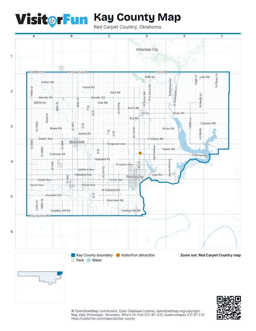
Maps inside Kay County
1 map inside, from the street map of Kay County down.
Street index of Kay County
Each street on the sheet and the grid squares it crosses.
- World War II Veterans Memorial HighwayB1, B2, B3, B4, B5, B6
- Kansas TurnpikeB1
- West South AvenueA5, B5, C5, D5
- North U StreetC1, C2, C3, C4, C5
- North Q StreetC1, B2, C2, C3, C4, C5
- North Main StreetB1, B2, D2, B3, D3, B5
- South 44th StreetB3, B4, B5, B6
- South South StreetC3, C4, C5
- South P StreetB3, B4, B5, B6
- South T StreetC3, C4, C5
- South Main StreetB3, D3, B4, B5
- East Furguson AvenueE3, F3, D4, E4
- East Tower RoadD4, E4, F4
- Sid Cookerly Memorial HighwayD3
- South O StreetB3, B4, B5, B6
- Pleasant View RoadD3, D4, D5
- North 14th StreetD4
- Tribal Elder Parrish Williams Memorial HighwayD5, D6
- North Pleasantview RoadD4
- East Harding RoadD5
- Frontage RoadB5
- West South StreetD3
- South 14th StreetD4, D5
- 4th StreetB2, C5, D5
- BroadwayB2
- South Hoover RoadA1
- West Highland AvenueA4, B4, C4, D4
- North Union StreetD2, D3, D4
- West Doolin AvenueA3, B3, C3
- West Hartford AvenueA4, B4, C4, D4
- East Kildare RoadD3, E3, F3
- Senator David Myers Memorial HighwayD4, E4
- Lake RoadD4, E4
- East Prospect AvenueD4, E4
- East Coleman RoadD4, E4, F4
- West Prospect AvenueA4, C4, D4
- North 5th StreetB3, D4, B5
- South Ranch DriveC5, C6
- East Hartford AvenueD4
- South Ranch RoadC5
- South Waverly StreetD4, D5
- North Waverly StreetD4
- West Grand AvenueC4, D4, B5
- North 1st StreetB3, D4, B5
- East Grand AvenueD4, B5
- East North AvenueB5
- North Pine StreetD4, B5
- East Highland AvenueD4
- East Doolin AvenueB3
- East John B Hayes RoadD4
- John B Hayes RoadD4
- West Bender RoadA2, B2, C2, D2, E2
- North 140th StreetA1, A2, A3, A4, A5
- West Hubbard RoadA4, B4, C4, D4
- North la Cann RoadD1, D2, D3, D4
- West Furguson AvenueB3, C3, B4, C4, D4
- West North AvenueA5, B5, C5
- North Pecan RoadD2, D3, D4
- South 13th StreetB3, B4, D4, B5, D5, B6
- East River RoadD3, E3, F3
- West Fountain RoadA5, B5, C5, D5
- West Oakland RoadA5, B5, C5, D5
- North 13th StreetB2, B3, D4
- North Silverdale LaneE1, E2, E3, E4
- East Hubbard RoadD4, E4
- East Dry RoadD3
- South Q StreetC3, C4, C5, C6
- Oakland RoadA5, B5
- East Fork RoadD2, E2
- East South AvenueD4, D5, E5
- 13th StreetB1, B2, B5
- South 106th LaneE3
- East Fountain RoadC5, D5
- North 106th LaneE2, E3
- Fountain RoadA5, C5
- North 7th StreetB3, D4, B5
- East Furguson RoadF3, D4, F4
- North Pleasant ViewD2, D3
- North AvenueC5
- L A Cann DriveD4
- South 7th StreetB3, D4, B5, D5
- Silverdale RoadE4, E5
- South 1st StreetB3, B4, D4, B5, D5
- South 4th StreetB3, B4, D4, B5, D5
- North 6th StreetB3, D4, B5
- Main StreetB2, B4, B5
- South 6th StreetB3, B4, D4, D5
- Ranch DriveC4, C5
- Pecan RoadD3, D4, D5
- East Cowboy Hill RoadD5
- Ash StreetD4
- West Blackwell AvenueB3
- East 7th StreetD3
- East Central AvenueD4
- West Broadway AvenueD4
- Monument RoadD4
- West Coolidge AvenueB4
- North Public StreetB5
- White Eagle DriveD5, D6
- Waverly StreetD4
- North Lacann RoadD3
- South Pine StreetD4, B5, D5
- North Ash StreetD4
- East Lake RoadD4, E4
- South AvenueD5
- West 1st StreetD3
- East Blackwell AvenueB3
- Church StreetD3
- Allen DriveB5
- Lucas StreetD5
- South Public StreetB5
- 8th AvenueD3
- North Hubbard RoadD4
- Pioneer Woman CircleD4
- Kaw Dam RoadE4
- West Brookfield AvenueD4
- Kelley AvenueD5
- 8th StreetD3
- Public StreetB5
- South 76th StreetA2, A3, A4, A5, A6
- South 124th StreetA2, A3, A4, A5, A6
- West Brake RoadA3, B3, C3, D3
- West Gate RoadA2, B2, C2, D2, E2
- South 108th StreetA2, A3, A4, A5, A6
- West Earth RoadA2, B2, C2, D2
- West Adobe RoadA3, B3, C3, D3
- South 60th StreetB2, B3, B4, B5, B6
- West Dry RoadA3, B3, C3, D3
- North 92nd StreetA1, A2, A3, A4, A5
- West Coleman RoadA4, B4, C4, D4
- North Ranch DriveC1, C2, C3, C4
- North Prentice RoadD1, D2, D3, D4
- South 29th StreetB3, B4, B5, B6
- West Cowboy Hill RoadA5, B5, C5, D5
- West Fork RoadB2, C2, D2
- North R StreetC1, C2, C3, C4, C5
- North W StreetC1, C2, C3, C4
- West Canteen RoadA3, B3, C3, D3
- West Indian RoadA2, B2, C2, D2
- North Enterprise RoadE1, E2, E3, E4
- West Home RoadA2, B2, C2, D2
- North T StreetC1, C2, C3
- North S StreetC1, C2, C3
- North P StreetB1, B2, B3
- West Riverview RoadA5, B5, C5, D5
- West Judo RoadA2, B2, C2
- East Canteen RoadD3, E3, F3
- West White Eagle RoadA5, B5
- West Peckham RoadA3, B3, C3
- East Home RoadD2, E2, F2
- West Chrysler AvenueA4, B4
- North Traders Bend RoadD2, D3
- East Chrysler AvenueB4, C4, D4
- West State Line RoadA1, B1, C1
- North Hardy LaneE2, E3
- 332nd RoadC1, D1, E1, F1
- Hartford AvenueB4, C4, D4, E4
- East Judo RoadD2, E2, F2
- North Waverly RoadD1, D2, D4
- North O StreetB2, B3
- 44th StreetB1, B2, B3, B5
- East Brake RoadD3, E3
- 29th StreetB1, B2, B3, B5
- South R StreetC3, C4, C5, C6
- North 60th StreetB1, B2
- South U StreetC3, C4, C5, C6
- Peckham RoadB3, C3, D3
- Furguson AvenueA3, B3, A4
- Hubbard RoadC4, D4
- East Adobe RoadD3, E3
- E0070 RoadA2, B2, E2
- East Indian RoadD2, E2, F2
- North 44th StreetB2, B3
- Prospect RoadB4
- East 200th Street SouthA1, B1
- South Sage LaneE1, E2, E4
- White Eagle RoadA5, C5, D5
- South Pleasant View RoadD5, D6
- O StreetB3, B4
- South 140th StreetA5, A6
- North Rock Cliff RoadD3, D4, D5
- North Bear Creek RoadE2, E3
- North 108th StreetA1, A2
- West County Line RoadA6
- R StreetC5
- North Olsen LaneF1, F2
- Hardy LaneE3, E4
- East Gate RoadD2, E2, F2
- North WaverlyD3
- South 92nd StreetA5, A6
- North Longwood DriveD1, D2
- Prospect AvenueC4, D4
- East Earth RoadD2, E2
- Snake RoadD4
- North Longwood RoadD2, D3, D4
- North East Longwood DriveD3, D4
- North East Longwood RoadD3, D4
- Home RoadB2
- Indian RoadB2
- Judd RoadB2
- North 124th StreetA1, A2
- North 76th StreetA2
- Longwood RoadD4, D5
- East County Line RoadC6, D6
- Fork RoadB2
- East Bender RoadD2, E2
- N3505 RoadF3, F4
- Rocky Ridge RoadE4
- John Dohl RoadF3
- East Riverview RoadC5, D5
- North 4th StreetB3, D4, B5
- Gate RoadB2
- Southwest StreetC5
- South 9th StreetB3, B4, D4, B5, D5
- South 2nd StreetB3, B4, D4, B5, D5
- T StreetC5
- South 3rd StreetB3, B4, D4, B5, D5
- Canteen RoadE3, F3
- North Pleasant View RoadD2, D4
- Eagles Nest RoadB6, C6
- South Union RoadD5
- North 3rd StreetB3, D4, B5
- South 11th StreetB3, B4, D4, B5, D5
- West Oklahoma AvenueB3, D4, B5
- North Sage LaneE2
- South W StreetC3, C4
- West 92nd StreetA2
- East White Eagle RoadD5
- Q StreetC5
- North Payne RoadF2, F3
- East Oklahoma AvenueB3, D4, B5
- South 5th StreetB3, D4, B5, D5
- North 2nd StreetB3, D4, B5
- South 12th StreetB3, B4, D4, B5, D5
- South 8th StreetB3, B4, D4, D5
- South 156th StreetA5
- Cowboy Hill RoadC5, D5
- El Camino StreetD4
- South 10th StreetB3, B4, D4, B5, D5
- Break RoadE3
- North 9th StreetB3, D4, B5
- Dry RoadB3, E3
- North 29th StreetB2, B3
- West College AvenueB3, B5
- East Noc DriveB5
- South WaverlyD5
- North Osage StreetD4
- West Central AvenueC4, D4
- N3110 RoadA1, A5
- Rocky Ridge PlaceE4
- Turner StreetD4
- Meadow LaneB3, D4, B5
- South B StreetB3, B4
- Fairview AvenueB4, D4
- West Padon AvenueB3
- South Enterprise RoadE4, E5
- North 8th StreetB3, D4
- West Lincoln AvenueB3
- E0010 RoadC1, D1, E1
- West Dewey AvenueB3
- Meadowbrook StreetD4
- Coolidge AvenueB4
- Grandview DriveE4
- North Virginia AvenueD4
- North 11th StreetB3, D4, B5
- West Bridge AvenueB3
- Acker Hill RoadE4
- County Line RoadC6
- North 10th StreetD4, B5
- North Oak StreetD4
- North Range LaneF3
- Waverly RoadD2, D3
- North Birch StreetD4
- North Hilltop RoadE3
- E0195 RoadA4
- West RiverviewA5, B5
- N124th StreetA2
- North West RoadC2, C3
- East Tonkawa AvenueB5
- West 108th StreetA2
- South Q atC4
- East Riverview PlaceD5
- Industrial RoadC4, D4
- N3245 RoadC4
- North East Pecan RoadD3
- West Liberty AvenueD4
- West Summit AvenueD4
- E0045 RoadD2
- E0105 RoadB3
- N3310 RoadD4
- North Range RoadF1, F2
- West Industrial BoulevardC4
- Overlook RoadA2, E4
- Kygar RoadD4
- East College AvenueB3, B5
- Noble RoadA2
- South 92 DriveA5
- West River RoadA5
- South Pine AvenueD3
- Bluff Creek LaneA2
Things to do on the Kay County map
Places on the map
- Blackwell
- Blackwell Cemetery
- Blackwell Fairgrounds
- Blackwell Tonkawa Municipal Airport
- Blinn Park
- Braman
- Braman Cemetery
- Camp Lew Wentz
- Cann Memorial Gardens
- Dan Moran Park
- Eagles Landing Ultralight Flightpark
- Earl Henry Airport
- Garfield Park
- Grass Roots Airport
- Green Park RV Resort
- Johnson Park
- Kaw City
- Kaw Lake
- Kaw Lake Scenic Outlook Park
- Kaw Nation
- Kaw NationLibrary
- Kildare
- Lake Ponca North Park
- Lake Ponca Park South
- McFadden Cove Campground
- Meadowbrook Village
- Miller Brothers 101 Ranch
- Newkirk
- Newkirk Country Club Lake
- Pioneer Park
- Ponca City
- Ponca City Country Club
- Ponca City Regional Airport
- Ponca Tribe
- Saint Marys Cemetery
- Standing Bear Park and Trails
- Tonkawa
- Tonkawa Tribe
- Wentz Golf Course
- West Lake Ponca;East Lake Ponca
Next to Kay County
- Arkansas City
© OpenStreetMap contributors, Open Database License, openstreetmap.org/copyright · Map data: Protomaps · Boundary: Who's On First (CC-BY 4.0); Quattroshapes (CC BY 2.0)















