

Oklahoma map
Ponca City map
About 24,234 people live here (Census Bureau, 2024 estimate). The sheet's index lists 300 streets; North 5th Street, North 14th Street and North Union Street cross the most grid squares. Also on it: Ponca City Regional Airport, Lake Ponca North Park and Standing Bear Park and Trails.
Open the map (PDF, US Letter)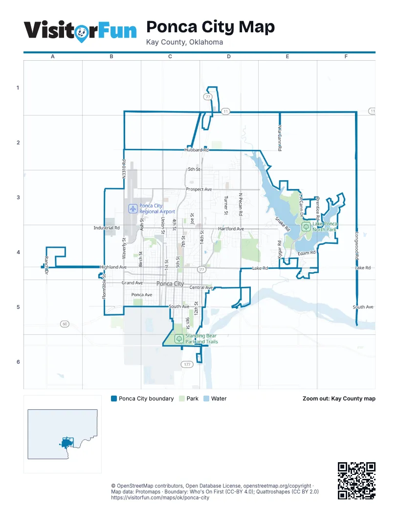
Street index of Ponca City
Each street on the sheet and the grid squares it crosses.
- North 14th StreetD2, D3, D4, D5
- East Harding RoadC6, D6
- South 14th StreetD5
- West Highland AvenueA4, B4, C4
- North Union StreetC2, C3, C4, C5
- East Prospect AvenueC3, D3, E3, F3
- North 5th StreetC2, D2, C3, C4, C5
- East Hartford AvenueC4, D4, E4
- Lake RoadD4, E4, F4
- West Grand AvenueB5, C5
- West Hartford AvenueB4, C4
- North Waverly StreetB4, B5
- North 1st StreetC4, C5
- North Pine StreetC4, C5
- East Highland AvenueC4, D4
- East Grand AvenueC5, D5
- South Waverly StreetB5
- West Prospect AvenueB3, C3
- John B Hayes RoadD1
- Senator David Myers Memorial HighwayD1
- North Pecan RoadD1, D2, D3, D4
- L A Cann DriveE3, E4
- East Hubbard RoadD2, F2
- West South AvenueB5, C5
- North 7th StreetC3, C4, C5
- Ash StreetC3, C4, C5
- South 7th StreetC5, C6
- East South AvenueC5, D5, F5
- East Central AvenueC5, D5
- West Broadway AvenueB4, C4
- Monument RoadD4
- South 4th StreetC5
- Waverly StreetB3, B4
- North Ash StreetC3, C4
- South Pine StreetC5
- Ranch DriveA4
- South 1st StreetC5
- Lucas StreetC5, C6
- Pecan RoadD4
- South AvenueD5
- North Hubbard RoadC2, D2
- Pioneer Woman CircleD4
- West Brookfield AvenueC4
- Kelley AvenueD5
- Snake RoadD2, D3, E3, E4
- Longwood RoadF3, F4, F5
- El Camino StreetD2, D3, D4
- North 4th StreetC3, C4, C5
- North Osage StreetC3, C4, C5
- North 3rd StreetC4, C5
- Turner StreetD3, D4
- West Central AvenueB5, C5
- West Hubbard RoadB2, C2
- South 9th StreetC5
- South 6th StreetC5
- South 11th StreetC5
- North 2nd StreetC4, C5
- Meadowbrook StreetD3, D4
- North Virginia AvenueC4, D4
- South 5th StreetC5
- North Oak StreetC4, C5
- North Prentice RoadF3, F4
- North la Cann RoadE1, E2
- Meadow LaneD3
- North Birch StreetB4, B5
- West Liberty AvenueB4, C4
- West Summit AvenueB4, C4
- N3310 RoadB2, B3
- South 8th StreetC5
- South 12th StreetC5
- Kygar RoadE4
- West Oklahoma AvenueB5, C5
- East Oklahoma AvenueC5, D5
- Fairview AvenueC3, C4
- East Otoe AvenueC5, D5
- East Ponca AvenueC5, D5
- North 6th StreetC3, C4, C5
- West Ponca AvenueB5, C5
- Kingston RoadD2, D3
- North Peachtree StreetB4, B5
- North Sunset StreetB4, B5
- Edam RoadE4, F4
- South 13th StreetC5, D5
- North Elm StreetC4, C5
- East Chestnut AvenueC4
- Princeton AvenueC3, D3
- West Cleveland AvenueB5, C5
- East Walnut AvenueC5, D5
- East Bradley AvenueC3, D3
- East Hazel AvenueC4
- West Hazel AvenueB4, C4
- Hubbard RoadC2
- South 10th StreetC5
- East Maple AvenueC5
- Overbrook AvenueC4
- Industrial RoadB4
- Canterbury AvenueD4, E4
- West Otoe AvenueB5, C5
- Lansbrook RoadC3
- West Chestnut AvenueB4, C4
- North Lake StreetC4, C5
- Stoneridge RoadE3, E4
- East Broadway AvenueC4
- East Cleveland AvenueC5
- Pleasant View RoadD2, D6
- North Palm StreetC4, C5
- South Palm StreetC5
- West Emporia AvenueC4
- South Ash StreetC5
- South Osage StreetC5
- Elmwood AvenueC4, D4
- South Oak StreetC5
- Hillcrest DriveD4, D5
- South 2nd StreetC5
- South 3rd StreetC5
- Young AvenueC3
- South Elm StreetC5
- Shirlee AvenueC3, D3
- East Albany AvenueC4
- East Overbrook AvenueC4, D4
- East Cherry AvenueC5
- Bluestem RoadD3
- Rosedale DriveE4
- Donner AvenueD3
- Pioneer RoadD4
- Rice StreetD3
- South Franklin StreetB5
- South Lincoln StreetB5
- Joe StreetC3, C4
- Mary StreetC3, C4
- John StreetC3, C4
- Hall BoulevardB3, B4
- Prospect AvenueB3
- Willow AvenueD3
- Edwards AvenueC5, D5
- Summers PlaceE4
- East Fresno AvenueC4
- Williams AvenueC3
- South Lake StreetC5
- Whitworth AvenueC4, D4
- Brentwood DriveC3
- Queens AvenueD3
- North 13th StreetC4, D4, C5
- East Brookfield AvenueC4
- Perry StreetB5
- Homestead NorthD3
- North 12th StreetC4, C5
- North 11th StreetC4, C5
- Juanito AvenueD4
- North 10th StreetC4, C5
- North 9th StreetC4, C5
- North 8th StreetC4, C5
- Bradbary LaneC4
- Sugar Maple DriveD4
- South Peachtree StreetB5
- Edgewood DriveD4
- South Birch StreetB5
- North Irving StreetB4, B5
- North Olympia StreetB4, B5
- North Stephen StreetB4, B5
- Oriole StreetC3
- Cedar StreetD3, D4
- Dover DriveD3, D4, E4
- Holbrook StreetD4
- Madison AvenueC5, D5
- Mockingbird DriveD3
- Warwick RoadC3
- 4th StreetC5, C6
- Jane StreetC3, C4
- East Emporia AvenueC4
- Cardinal RoadD3
- Academy RoadE4
- East Comanche AvenueC4
- Cookson DriveD4
- Marland DriveC5
- Santa Fe RoadC2
- Lakeview DriveF4
- Windsor RoadC3
- Ames AvenueD3
- Prentice DriveE3, F3
- Clarke StreetC4
- East Liberty AvenueC4
- Donahoe DriveC4
- Stoneridge DriveE3, E4
- East Woodland RoadD4
- North Flormable StreetB4
- Cascade DriveE4
- Kyme StreetD3
- Poplar AvenueC4
- Huntington PlaceD3
- Larchmont AvenueD4, E4
- Crawford AvenueD3
- South Sunset StreetB5
- West Cherry AvenueB5, C5
- Donald AvenueD3
- East Detroit AvenueC4
- East Alma AvenueC5
- East Drummond AvenueC5
- Roosevelt AvenueC4
- East Park AvenueC4
- East Houston AvenueC5
- Erie AvenueC6
- Briar Ridge RoadD2
- Wellington RoadD2
- Hillside AvenueC4
- Glenside AvenueC4, D4
- Marina DriveE4
- Whitlock LaneD2
- Garden StreetC3
- West Gary AvenueC4
- McFadden DriveC5
- Eagle RoadC3
- McGraw DriveC4
- Wood Thrush RoadD3
- Larkspur DriveE4
- East Woodbury RoadC3
- Berkshire DriveD3
- West Darr RoadC3
- Coronado StreetD4
- Drake DriveD4
- Cleary DriveD4
- Autumn RoadD4
- North Woodland RoadD4
- Airline DriveB4
- Riggs DriveC4
- Wildwood AvenueD4
- Greenbriar RoadC3
- Sykes BoulevardB3
- Cedar LaneD4
- Goldenrod AvenueE4
- Hudson DriveC4
- Redbird DriveC3
- Blackard LaneD4
- West Park AvenueC4
- Northeast Woodland RoadD4
- Hampton DriveB4
- Potomac DriveC4
- Canary DriveC3
- Sherman LaneE4
- Broadway AvenueB4
- East England AvenueC5
- North Waverly RoadB2
- East Gary AvenueC4, D4
- South Washington StreetB5
- Westbury RoadC3
- Bellflower AvenueE4
- Mockingbird LaneD3
- Rockview RoadD2
- Checkstand RoadE3
- Richway DriveC4
- Dalewood LaneD4
- Martha AvenueC3
- Blake DriveD4
- Hathaway StreetD4, E4
- Robin RoadD3
- East Madison AvenueC5
- East Scott AvenueC5, D5
- East Summit AvenueC4
- Spring RoadD4
- Cooley AvenueC4, D4
- West Fresno AvenueC4
- Riveria DriveC4
- Washington StreetB5
- Viola AvenueC4, D4
- Deer PlaceD3
- East Lake DriveE4
- Trio LaneD4
- Hartford AvenueF4
- Wren DriveC3
- Miller AvenueC5
- De Soto StreetD4
- Avon AvenueD4
- WoodcrestE4
- Red Oak DriveD4
- Revelle DriveD4, E4
- Gray AvenueC4
- Little LaneC4
- Marcella AvenueC3
- Fawn LaneE4
- Ashbury RoadD2
- West Overbrook AvenueB4
- Quail LaneD4
- Yale AvenueD3
- Hummingbird LaneD3
- Havenwood RoadD3
- Greenwood AvenueB4
- Chapel Hill RoadD2
- Rose LaneD4
- Bluebird LaneD3
- Frontier AvenueE4
- Woodridge DriveE4
- Lonnie AvenueC3
- Mistletoe DriveE4
- East Hillcrest DriveD5
- Pecan PlaceD3
- Broughton RoadC3
- Shannon RoadC3
- Winter Green AvenueD3
- East Hartford RoadF4
- Christmas Tree LaneD4
Places on the map
- Aesthetic State of Mind
- ALDI
- Allen Robson Fieldhouse
- AMC CLASSIC Ponca City 4
- Americas Best Value Inn
- Asbury United Methodist Church
- Atwoods
- Auto 2 Go
- Bank of the West
- Braum's
- Camp Lew Wentz
- Cann Memorial Gardens
- Cato
- City Hall, City of Ponca City
- Comfort Inn & Suites
- Conoco
- Conoco Museum
- Dan Moran Park
- Garfield Park
- Johnson Park
- Lake Ponca Beach
- Lake Ponca North Park
- Lake Ponca Park South
- Liberty Park
- Marland Mansion
- Meadowbrook Village
- Pioneer Woman Monument
- Ponca City Assembly
- Ponca City Country Club
- Ponca City Regional Airport
- Ponca City Senior High School
- Redbud Park
- Sherwood Park
- Standing Bear Park and Trails
- Unemployment Agency
- Walmart Supercenter
- War Memorial Park
- Wentz Golf Course
- West Lake Ponca;East Lake Ponca
- Willow Springs Park
© OpenStreetMap contributors, Open Database License, openstreetmap.org/copyright · Map data: Protomaps · Boundary: Who's On First (CC-BY 4.0); Quattroshapes (CC BY 2.0)















