

Oklahoma road map
Oklahoma highway map
7 Interstate routes run about 941 miles in Oklahoma, each on a sheet of its own. The sheet's index lists 46 highways; I-44, I-35 and I-40 cross the most grid squares. Towns on it: Oklahoma City, Tulsa and Norman.
Open the map (PDF, US Letter)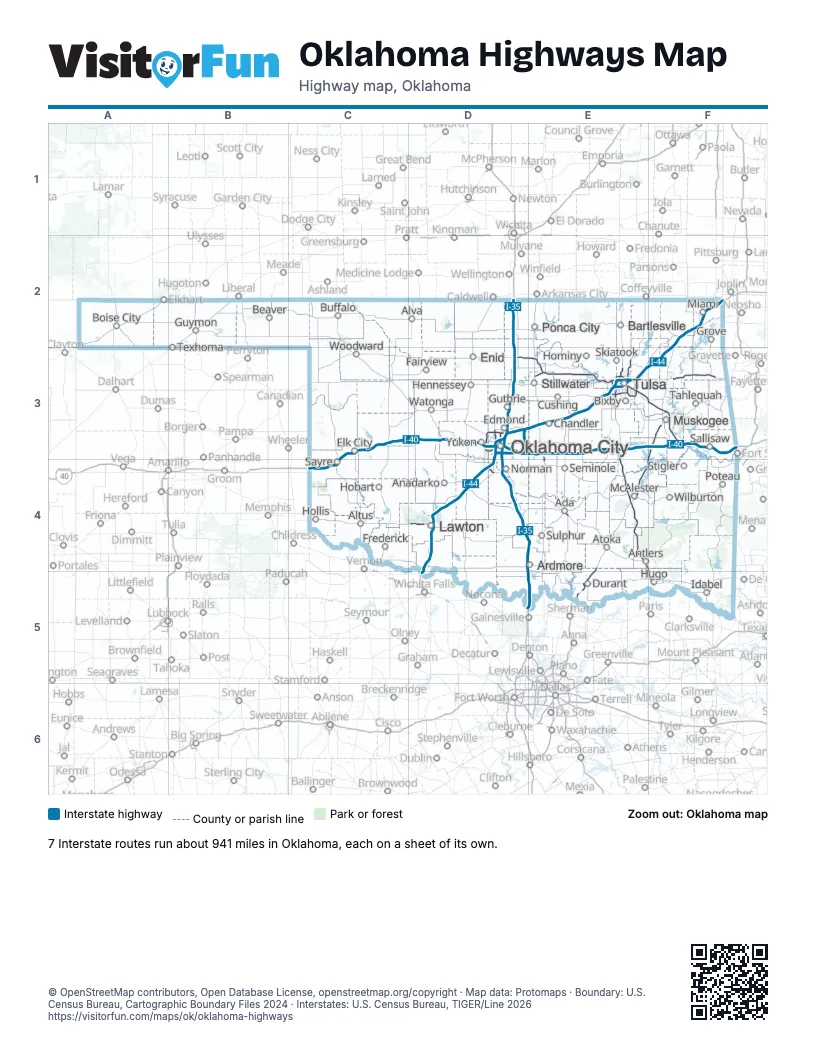
Road maps of Oklahoma
7 road maps: each Interstate and byway on a sheet of its own.
Highway index of Oklahoma
Each highway on the sheet and the grid squares it crosses.
- I-35D2, D3, D4, E4, E5
- I-40C3, C4, D3, E3, F3
- I-44D3, D4, D5, E3, F2, F3
- I-235D3
- I-240D3
- I-244E3
- I-335D3
- I-344D3
- I-540F4
- US 62D3, D4, E3
- US 64D3, E3
- US 69E4, E5, F3, F4
- US 70D4, E4, E5, F5
- US 75E3, E4, E5
- US 77D3, D4, E5
- US 169E3
- US 177E3, E4
- US 270D3, E3, E4
- US 271F4, F5
- US 277D4, D5
- US 281D4, D5
- US 377E4
- US 412D3, E3, F3
- OK 1E4
- OK 3D3, E3, E4
- OK 3EE3, E4
- OK 4D4
- OK 9D4
- OK 11E3
- OK 20E3
- OK 34C3
- OK 37D3, D4
- OK 51E3
- OK 53D4, E4
- OK 66D3, E3
- OK 74D3
- OK 99E4
- OK 102E3
- OK 152D3
- OK 165F3
- OK 266E3
- OK 312E3
- OK 344E3
- OK 351E3, F3
- OK 364E3
- OK 375E3, E4, F4, F5
Places on the map
- Ada
- Altus
- Alva
- Anadarko
- Antlers
- Ardmore
- Atoka
- Bartlesville
- Beaver
- Bixby
- Boise City
- Buffalo
- Chandler
- Cushing
- Durant
- Edmond
- Elk City
- Enid
- Fairview
- Frederick
- Grove
- Guthrie
- Guymon
- Hennessey
- Hobart
- Hollis
- Hominy
- Hugo
- Idabel
- Lawton
- McAlester
- Miami
- Muskogee
- Norman
- Oklahoma City
- Ponca City
- Poteau
- Sallisaw
- Sayre
- Seminole
- Skiatook
- Stigler
- Stillwater
- Sulphur
- Tahlequah
- Texhoma
- Tulsa
- Watonga
- Wilburton
- Woodward
- Yukon
© OpenStreetMap contributors, Open Database License, openstreetmap.org/copyright · Map data: Protomaps · Boundary: U.S. Census Bureau, Cartographic Boundary Files 2024 · Interstates: U.S. Census Bureau, TIGER/Line 2026