

Oklahoma map
Tahlequah map
About 17,319 people live here (Census Bureau, 2024 estimate). The sheet's index lists 300 streets; 42nd "Rainbow" Infantry Division Memorial Highway, South Muskogee Avenue and West Choctaw Street cross the most grid squares. Also on it: Cherokee Springs Golf Club, Heritage Elementary School and Northeastern State University.
Open the map (PDF, US Letter)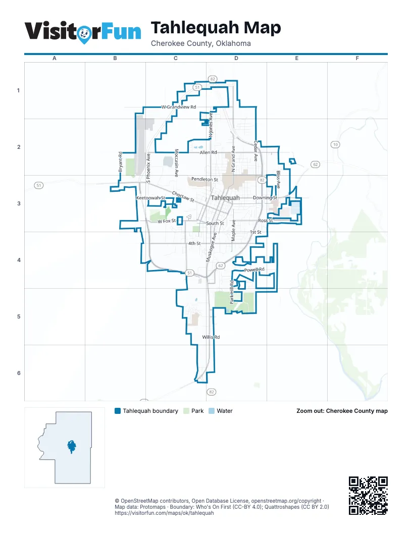
Street index of Tahlequah
Each street on the sheet and the grid squares it crosses.
- 42nd "Rainbow" Infantry Division Memorial HighwayB3, C3, D3, E3, C4, D4
- South Muskogee AvenueD3, D4, D5, C6, D6
- Bertha Parker BypassD2, D3
- West Choctaw StreetB3, C3, D3
- North Cedar AvenueD1, D2, D3
- East Downing StreetD3, E3
- Daisy DriveC4, D4
- North Grand AvenueD1, D2, D3
- North Muskogee AvenueD3
- Valley AvenueD3
- West Fox StreetB3, C3, D3
- North Jones AvenueD1, D2, D3
- West Allen RoadC2, D2
- East Ross StreetD3, E3
- West 4th StreetC4, D4
- East Allen RoadD2, E2
- East 4th StreetD4
- East Shawnee StreetD3, E3
- West Grandview RoadC1, D1
- South Maple AvenueD3, D4
- South College AvenueD3, D4
- South Mission AvenueC3, D3, C4
- South Bluff AvenueD3, D4
- Crafton StreetD2, E2
- Stick Ross Mountain RoadC4
- Hillcrest AvenueC3, C4
- Cherokee Springs RoadD5
- South Lee AvenueC3, D3
- West South StreetC3, D3
- North College AvenueD3
- Mahaney AvenueD4
- North Mission AvenueD3
- Nancy Ward DriveD5
- East Choctaw StreetD3
- Rayne StreetD4
- North Bluff AvenueD3
- West Keetoowah StreetB3, C3, D3
- North Vinita AvenueD1, D2, D3
- Park Hill RoadD4, D5
- South Phoenix AvenueC2, C3
- North Oklahoma AvenueD2, D3
- Pendleton StreetC2, C3, D3
- North Bliss AvenueE2, E3
- South State AvenueC3, D3, C4
- East Ballentine RoadD5
- Powell RoadD4, E4
- North Moccasin AvenueC2, C3
- East Boone StreetD3, E3
- West Downing StreetC3, D3
- South Cedar AvenueD3, D4
- Airport ParkwayC2
- Seminary AvenueD2, D3
- West Delaware StreetC3, D3
- East Ward StreetD3, E3
- Cambridge CircleD4, D5
- South Cherokee AvenueD3, D4
- North Bryant RoadB2, B3
- Meadow Creek DriveC4, D4
- Highland DriveC5
- North East AvenueD3
- South West AvenueC3
- Southridge RoadC5, D5
- West Shawnee StreetC3, D3
- Goingsnake StreetD3, E3
- West 1st StreetC3, C4, D4
- Basin AvenueD4
- Career Tech WayC3
- East Seneca StreetD2
- East 1st StreetD4
- Dogwood DriveD4
- West Willis RoadC5, D5
- Campbell RoadC3, C4
- North StreetD2
- Crestwood DriveC6, D6
- Legion DriveE3
- North Oak AvenueD3
- Main ParkwayC2, C3
- West Ross StreetC3, D3
- White AvenueD4, D5
- Wilson AvenueD3
- College CourtD3, D4
- South Nalley RoadE3
- South Water AvenueD3
- Kim StreetD2
- North Heritage LaneD2
- Redbud LaneD4
- Hickory DriveD4
- West Chickasaw StreetC3, D3
- Coy AvenueD2, D3
- East Fuller StreetD3, E3
- South Moccasin AvenueC3
- West Mud Valley RoadB4, C4
- West 750 RoadB2
- Mill RoadC5, D5
- South East AvenueD3, D4
- Mathis Park DriveC2, D2
- May AvenueD3, D4
- South Sooner DriveD3, D4
- Trimble AvenueD2
- North Water AvenueD3
- Wheeler StreetD2
- West 2nd StreetC4, D4
- East South StreetD3
- Minor StreetD2
- East 7th StreetD4
- Sasha LaneC1, D1
- Golf Course RoadB2
- West Seneca StreetD2
- York StreetD2
- Jamestown StreetD2
- Old River RoadE3
- West Morgan StreetD3
- Essary AvenueC3
- Echota AvenueD4
- Janet StreetD2
- North Ash AvenueD3
- East Arden StreetD2
- South 530 RoadE4
- East Lawrence RoadE2
- Clayton DriveC2
- Jackson AvenueD2
- East Keetoowah StreetD3
- East Normal StreetD3, E3
- Guinn AvenueD3, D4
- Northside CourtD2
- Aspen DriveC5
- South Park AvenueD3
- Mike Sheets DriveC3, D3
- Songbird DriveD1, D2
- North Sleepy Hollow LaneC1, C2
- Kindle AvenueD4
- Kelly StreetD4
- Tanglewood DriveD4
- Muskogee PlaceD4
- South Harrison AvenueD3
- Turney AvenueD4
- D0765 RoadD2, E2
- Garden RoadD3, D4
- Kaufman AvenueD4
- South Morris AvenueC3
- Sycamore DriveD4
- North Cherokee AvenueD3
- Pat StreetD2
- Brewer AvenueC3
- Diffee DriveD4, D5
- East 5th StreetD4
- Larry AvenueD4
- N4500 RoadB4
- Oklahoma AvenueD1, D2
- Hensley DriveC4
- Markoma DriveC4
- Kay LaneE2
- Spring StreetD3
- Mayberry DriveC4
- Plaza DriveE3
- Bean StreetC3
- South Owens AvenueC4
- Francis AvenueD2
- Turpin LaneC4
- Keetoowah CourtC3
- Chapman DriveD3
- Jamestown DriveD2
- Monroe StreetD4
- Garden Lake DriveC5
- Magnolia StreetD3
- West 3rd StreetC4, D4
- Greenwood DriveD3
- Pamela StreetD4
- Persimmon StreetC3
- Jeffery StreetD4
- Mimosa LaneD4
- Rolling Hills DriveD4
- South Bliss AvenueE3
- Academy StreetD3
- Bryan BoulevardC3, C4
- Tommye LaneD3
- West College AvenueD4
- Callie AvenueD2
- Lexington AvenueC5
- Reasor StreetD4
- Circle StreetD3
- Remington PlaceD3
- Graham AvenueC4
- Elizabeth LaneC4
- Nola AvenueC4
- Earl StreetD3
- Mike AvenueD2
- Gerri DriveD1
- Parker StreetC3, D3
- Hensley StreetC4, D4
- Lewis AvenueD2, D3
- North Vinita StreetD1
- Jay LaneD4
- South Bryant RoadB3
- Lane AvenueE2
- West Allen CircleC2
- West 765 RoadB3
- West Arkhola StreetC5, D5
- McSpadden CourtC4, D4
- South Lena AvenueE3
- South Whitmore LaneC5
- Carol StreetD2
- Ashley LaneD3
- Russel AvenueD3
- Oak Hill LaneC3
- Harris CircleE3
- South Logan DriveD3
- North Legion DriveE3
- East Smith StreetD3
- George Guess RoadD5
- Quail Ridge DriveD3
- Greentree DriveD3
- Chase AvenueC4
- Evans StreetD4
- Hugh AvenueD2
- Miller DriveC3
- Skipper DriveD2
- Elm StreetD3
- North Maple AvenueD3
- Crafton PlaceD2
- South Ross AvenueC4
- Brentwood DriveD3
- Victor StreetD3
- Butler StreetD3
- Cathy AvenueD2
- Louie Griffin CircleC5
- South Cedar PlaceD3
- Oakwood DriveD3
- Rozell AvenueC4
- Sandstone AvenueC3, C4
- East Cherrie StreetD3
- Leoser StreetD2
- Ransten DriveD3
- Rosewood PlaceC5
- Wooden AvenueD3
- Jo StreetD3
- 3rd StreetD4
- North State AvenueD3
- Wisteria LaneD2
- Birch LaneC5
- Garner AvenueC4
- East Chickasaw StreetD3
- Woodlawn AvenueD3
- Berry StreetD2
- South Seminole AvenueC3
- Day LaneD2
- Lamer AvenueC4
- North Brookside AvenueD3
- Northpark DriveD2
- Brenda AvenueD2
- Lakes DriveC5
- Willow AvenueD4
- West Arden StreetD2
- Briar LaneC5
- Forest Ridge DriveD3
- North West AvenueC3
- Nsu DriveD2
- Summit AvenueD3
- East Delaware StreetD3
- East Willis RoadD5
- Glover AvenueD4
- Daniel Stern DriveD2
- McKie StreetD2
- Southland DriveD5
- Talley StreetD2
- Holiday DriveD4
- Don AvenueD2
- Oak AvenueD3
- Short StreetD3
- Nottey Acres DriveD1
- Lou Ellen StreetD3
- Lois LaneD2
- West 3rd PlaceC4
- Hillside AvenueE3
- Creekside DriveD2
- South 511 RoadC6
- Redwood PlaceC5
- Roosevelt AvenueD4
- South 527 RoadE3
- Jeanette LaneC6
- Cecilia DriveD2
- Judy LaneC3
- Lola StreetC2
- Sheryl StreetC2
- Sleepy StreetC2
- South 524 RoadE3
- Timbers LaneC5
- Beth Harrington AvenueD3
- Griffin AvenueD3
- Baker AvenueD2
- East Belcher LaneD2
- Patti June StreetD2
- North 523 RoadD2
- Williams StreetD4
- Wheeler CircleC4
- Morris AvenueC3
- Richmond CircleC5
- State AvenueD3
- West Clay StreetD3
- Chickasaw StreetD3
Places on the map
- Aerofit Healthclub
- Armory Municipal Center
- Arvest
- At The Y Liquor
- Bagley Hall
- Baker's Furniture
- BancFirst
- Bank of Cherokee County
- Boom-a-rang Diner
- Buffalo Wild Wings
- Burger King
- Casey's General Store
- Center for the Performing Arts
- Chamber of Commerce;Information and Tourist Center
- Cherokee Arts Center
- Cherokee Capitol Square
- Cherokee National Peace Pavillion
- Cherokee Springs Golf Club
- Chicken Depot
- Church of Christ South College
- Cornerstone Fellowship
- Cox Drug
- Crossway Baptist Church
- Dan DeLoache Field
- Danny's Muffler & Tire
- Days Inn & Suites by Wyndham Tahlequah
- Dewain's Place
- Doc Wadley Stadium
- Dollar General
- Heritage Elementary School
- Mission Park
- Northeastern Health System
- Northeastern State University
- Plaza
- Riverlinks Golf Course
- Tahlequah Cemetery
- Tahlequah City Hall
- Tahlequah Middle School/High School
- Tahlequah Municipal Airport
- Walmart Supercenter
© OpenStreetMap contributors, Open Database License, openstreetmap.org/copyright · Map data: Protomaps · Boundary: Who's On First (CC-BY 4.0); Quattroshapes (CC BY 2.0)















