

Oklahoma map
Green Country map
The sheet's index lists 23 highways; I-44, US 64 and US 69 cross the most grid squares. Things to do inside the boundary: Blue Whale of Catoosa, Bob Dylan Center and Cain's Ballroom. Also on it: Bartlesville, Bixby and Bristow.
Open the map (PDF, US Letter)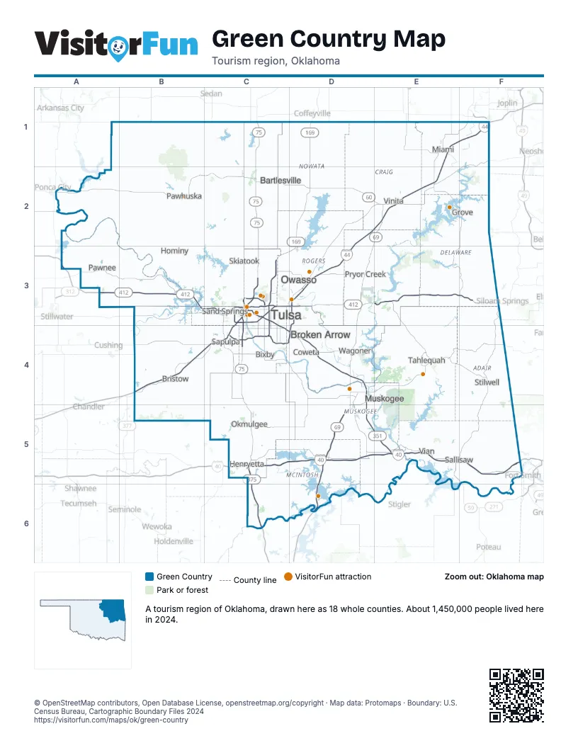
Highway index of Green Country
Each highway on the sheet and the grid squares it crosses.
- I-40C5, D5, E5, F5
- I-44B4, C3, C4, D2, D3, E1, E2, F1
- I-244C3
- US 59E5, F3, F5
- US 60C2, D2, E2
- US 62C5, D4, F4
- US 64B3, C3, C4, D4, D5, F5
- US 69D2, D3, D4, D5, D6, E2
- US 75C1, C2, C3, C4, C5
- US 169C3, C4, D1, D2, D3
- US 412A3, B3, C3, D3, E3, F3
- OK 10C1, D1
- OK 11C3
- OK 16D4
- OK 20C3
- OK 51C3, C4
- OK 66C3, C4
- OK 165D4
- OK 266D3
- OK 344C3
- OK 351C4, D4, D5, E5
- OK 364C4, D3, D4
- OK 375C5, C6
Things to do on the Green Country map
- Blue Whale of Catoosa
- Bob Dylan Center
- Cain's Ballroom
- Castle of Muskogee
- Cherokee Nation
- Fort Gibson National Cemetery
- Gathering Place
- Gilcrease Museum
- Golden Driller
- Grand Lake o' the Cherokees
- Greenwood Rising
- Hard Rock Hotel & Casino Tulsa
- Keystone State Park
- Lake Eufaula
- Natural Falls State Park
- Oklahoma Aquarium
- Osage Casino Hotel - Skiatook
- Osage Casino Ponca City
- Philbrook Museum of Art
- Sequoyah State Park
- The Pioneer Woman Mercantile
- Three Rivers Museum
- Tulsa Air and Space Museum
- Tulsa Zoo
- Will Rogers Memorial Museum
- Woody Guthrie Center
Places on the map
- Bartlesville
- Bixby
- Bristow
- Broken Arrow
- Coweta
- Grove
- Henryetta
- Hominy
- Miami
- Muskogee
- Okmulgee
- Owasso
- Pawhuska
- Pawnee
- Pryor Creek
- Sallisaw
- Sand Springs
- Sapulpa
- Skiatook
- Stilwell
- Tahlequah
- Tulsa
- Vian
- Vinita
- Wagoner
Next to Green Country
- Arkansas Ozarks
- Arkansas River Valley
- South Central Kansas
- Southeast Kansas
- Southwest Missouri
- Choctaw Country map
- Frontier Country map
- Red Carpet Country map
© OpenStreetMap contributors, Open Database License, openstreetmap.org/copyright · Map data: Protomaps · Boundary: U.S. Census Bureau, Cartographic Boundary Files 2024