

Oregon map
Ashland map
About 20,935 people live here (Census Bureau, 2024 estimate). The sheet's index lists 300 streets; Siskiyou Boulevard, East Main Street and Ashland Street cross the most grid squares. Things to do inside the boundary: Oregon Shakespeare Festival, Ashland Chamber of Commerce & Travel Ashland and Ashland Food Co-op.
Open the map (PDF, US Letter)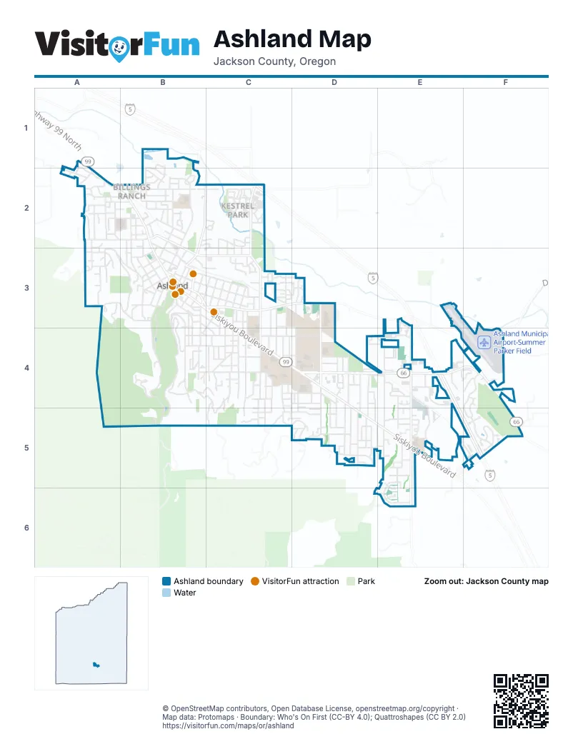
Street index of Ashland
Each street on the sheet and the grid squares it crosses.
- Highway #021AA - Pacific HIghway Connection #2E4
- Highway #001AD - Green Springs Connection #1E4
- HIghway #001AE - Green Springs Connection #2E4
- Highway #021AB - Pacific HIghway Connection #2E4
- Siskiyou BoulevardB3, C3, C4, D4, D5, E5
- Ashland StreetB4, C4, D4, E4, F4
- East Main StreetB3, C3, D3, E3, E4, F4
- North Main StreetA1, A2, B2, B3
- Lithia WayB3, C3
- Highway 99 NorthA2
- Green Springs HighwayF4
- Church StreetB3
- Dead Indian Memorial RoadF4
- Beaver SlideB3
- Tolman Creek RoadE3, E4, E5, E6
- North Mountain AvenueC2, C3
- Walker AvenueD3, D4, D5
- Oak StreetB2, B3
- South Mountain AvenueC3, C4, C5
- East Nevada StreetB2, C2
- East Hersey StreetB3, C3
- A StreetB3, C3
- West Hersey StreetB2, B3
- North 1st StreetB3
- Crowson RoadF5
- North 3rd StreetB3
- Clay StreetE3, D4, E4, E5
- Granite StreetB3, B4, B5
- Glenview DriveB3, B4, B5
- Morton StreetC3, C4, C5
- Iowa StreetB4, C4, D4
- Scenic DriveB2, B3
- Ashland Loop RoadB4, C4, C5
- Terrace StreetB3, B4
- Oak Knoll DriveF4, F5
- Park StreetD4, D5
- Helman StreetB2, B3
- Pinecrest TerraceC5, D5
- B StreetB3, C3
- Beach StreetC4, C5
- Winburn WayB3, B4
- Strawberry LaneA3, B3
- North Laurel StreetB2, B3
- Wimer StreetA2, B2
- Ditch RoadA3, B3
- West Nevada StreetB2
- Mistletoe RoadE4, E5
- Green Meadows WayE5, E6
- Liberty StreetC4
- Wightman StreetD3, D4
- Grandview DriveA3, B3
- Ridge RoadB3, B4
- Normal AvenueD4
- Holly StreetB4, C4
- Elkader StreetC4, C5
- High StreetB2, B3
- Hillview DriveD4, D5
- Randy StreetB2
- C StreetB3, C3
- Waterline RoadB4, C4, C5
- Garfield StreetC3, C4
- Cambridge StreetB2
- Beswick WayD4, D5
- Washington StreetE4
- Faith AvenueD4, D5
- Fork StreetB3, B4
- Ashland Creek DriveB4
- Van Ness AvenueB2, B3
- Indiana StreetD4, D5
- Walnut StreetA2
- Roca StreetC4, C5
- Sheridan StreetA2, B2
- Woodland DriveC5, D5
- Takelma WayE4
- Crestview DriveD5
- Clinton StreetC2
- Gresham StreetB3, B4
- Harmony LaneD4, D5
- Westwood StreetA3
- Cypress Point LoopF5
- Chestnut StreetA2
- Bellview AvenueE5
- Oregon StreetC4, D4
- Prim StreetA2
- Thornton WayA2
- Clear Creek DriveB3, C3
- Lit WayD4
- Fair Oaks AvenueC2
- Kestrel ParkwayC2
- Harrison StreetC3, C4
- Taylor StreetC4
- Jefferson AvenueE4
- Sutton PlaceE4, F4
- Water StreetB3
- Crocker StreetE3, E4
- Orange AvenueB2
- Guthrie StreetB4
- Benson WayF5
- Mountain Meadows DriveC2
- Jaquelyn StreetE4, E5
- Ashland Mine RoadA2
- Nutley StreetB3
- Hillcrest StreetB3, B4
- Glenwood DriveC4
- California StreetC3, C4
- Almond StreetB3
- Glendale AvenueD4, D5
- Maple StreetA2, B2
- Meadow DriveD4, E4
- Hitt RoadA3, A4
- Fordyce StreetC3
- Linda StreetD5
- Ray LaneD4
- Terra AvenueD5
- Meade StreetB3, B4
- Abbott AvenueE4
- Bush StreetB3
- Peachey RoadD5
- Drager StreetB2
- 4th StreetC3
- Windsor StreetC4, D4
- Bridge StreetC4
- Prospect StreetC4
- Sherman StreetC3, C4
- Leonard StreetC4, C5
- South Pioneer StreetB3, B4
- Garden WayD4, D5
- Madrone StreetC4, D4
- Homes AvenueD4
- Vista StreetB3
- Clark AvenueD4, D5
- Almeda DriveB2
- Lincoln StreetC3, C4
- 5th StreetC3
- Hargadine StreetB3
- North 2nd StreetB3
- Alta StreetB2, B3
- Dianne StreetE5
- Mary Jane AvenueE5
- Wrights Creek DriveA2, A3
- North Wightman StreetD3
- Euclid StreetC4
- Wiley StreetA2
- Morse AvenueC3, C4
- Williamson WayC3
- Audry CircleE4
- Glendower StreetB1, B2
- Schofield StreetA2
- Mohawk StreetD5, E5
- Ivy LaneC5
- Otis StreetB2
- Twin Pines CircleF4, F5
- Willow StreetB2
- Grant StreetA2, B2
- Mill Pond RoadC3, D3
- Palmer RoadC4, C5
- 6th StreetC3
- 3rd StreetB3, C3
- Frances LaneD4
- Oxford StreetB1, B2
- Patterson StreetC2, C3
- Forest StreetC4
- North Pioneer StreetB3
- 7th StreetC3
- Stoneridge AvenueC2
- Avery StreetC4
- Horn Creek RoadB5
- Central AvenueB3
- Manzanita StreetB3
- Alida StreetC3, C4
- Ashland Municipal AirportF4
- Allison StreetB3, C3
- Idaho StreetC4
- 8th StreetC3
- Black Oak WayE5
- Orchard StreetA3
- Morada LaneE5
- Catalina DriveA2, B2
- Henry StreetC4
- Union StreetC3, B4
- Weller LaneC4
- Parkside DriveB2
- Rock StreetB2
- Stadium StreetD4
- South Laurel StreetB3
- University WayC4
- Ohio StreetB2
- Nandina StreetC2
- Skycrest DriveA3
- Village Park DriveC3
- Fairview StreetB3, C3, C4
- Clover LaneE4
- Emma StreetC5
- Quincy StreetC3, D3
- Pracht StreetC4
- Ross LaneD5
- Brooks LaneE3, E4
- Starflower LaneC3
- Tudor StreetB2
- Lindsay LaneB2
- Lupine DriveE6
- Fox StreetA2
- Spring Creek DriveF4
- Courtney StreetB4
- Will Dodge WayB3
- Briscoe PlaceC2
- SunnyviewA3
- Tucker StreetA2
- Blackberry LaneE5
- Mountain Meadows CircleC2
- Village Square DriveC3
- Carol StreetC2, C3
- Ranch RoadE5, E6
- Ann StreetC2, C3
- Parker StreetD4
- Golden Aspen PlaceC2
- Nursery StreetB2
- Paradise LaneD5
- East DriveC2
- Engle StreetE4
- Pine StreetB3
- Nob Hill StreetB3
- Alnut StreetB3
- Plum Ridge DriveC2
- Independent WayE4
- Romeo DriveC3, D3
- Kent StreetB2
- Clay Creek WayE4
- Blaine StreetC3
- Palm AvenueC4
- Phelps StreetC2, C3
- Timberline TerraceD5
- Wedgewood LaneF4
- Plaza AvenueD5
- Nepenthe RoadC2
- Patton LaneC2
- Wolfard's AlleyC4
- Russell DriveC3
- Lori LaneB2
- Crispin StreetB2, C2
- Munson DriveC3
- Sander WayB2
- South 1st StreetB3
- Dollarhide WayE4
- Logan DriveB3
- Sunnyview StreetA3
- Coolidge StreetB2
- Nezla StreetD5
- Kirk LaneC3
- Emerick StreetC3
- Old Willow LaneC3
- Dragonfly LaneD5
- Pennsylvania StreetC4
- Herbert StreetB4
- Monte Vista DriveA2
- Nova DriveE5
- Vansant StreetB2
- Grizzly DriveE4
- Mallard StreetD3
- Barbara StreetE5
- Dewey StreetC3
- Coventry PlaceB1, B2
- Hunter CourtD4
- Birdsong LaneA3
- Kearney StreetC4
- Fernwood DriveA2
- Lee StreetC4, D4
- Michelle AvenueB2
- Old Mill WayE5
- Park Ridge PlaceC3
- Boulder Creek LaneC2
- Maple WayA2
- Altamont StreetC4
- Baum StreetB3
- Eastbrook WayB2
- Saint Andrews CircleF5
- Fremont StreetD4
- Sherwood StreetD4
- Piedmont DriveB3
- Ponderosa DriveD5
- Birchwood LaneE4
- Jessica LaneB2, C2
- Lilac CircleD5
- 9th Street AlleyC3
- Glenn StreetB2
- Long WayB4
- Spring WayE5
- Summit StreetB3
- Deer Vista LaneD5
- Tessa LaneA3
- Shamrock LaneD4
- Orchid StreetC3
- Rogue PlaceC3
- Rose LaneC3
- East Pebble Beach DriveF5
- Chitwood LaneE5
- Meadowlark WayC2
- Beach AvenueB3
- Sunrise DriveD4
- Voris AvenueB2
Things to do on the Ashland map
Places on the map
- 1951 Hwy 66
- 2nd Street Cottages
- 7-Eleven
- Ace Hardware
- Acid Boulders Trailhead
- Albertsons
- Allen Elizabethan Theatre
- Alliance Bible Chapel
- Angus Bowmer Theatre
- Asante Ashland Community Hospital
- Asante Family Medicine – Ashland
- Ashland Automotive
- Ashland Cemetery
- Ashland Creek Park
- Ashland Downtown Historic District
- Ashland Family YMCA
- Ashland High School
- Ashland Middle School
- Ashland Municipal Airport-Summer Parker Field
- Ashland Public Works
- Ashland Railroad Addition Historic District
- Ashland Shopping Center
- Bellview Elementary School
- Best Western Windsor
- Hald/Strawberry Park
- Helman Elementary School
- Hunter Park
- Liberty Street Park
- Mountain View Cemetery
- North Mountain Park
- Oak Knole Driving Range
- Oak Knoll Golf Course
- Oregon Shakespeare Festival
- Ropers Bunion
- Siskiyou-Hargadine Historic District
- Skidmore Academy Historic District
- Southern Oregon University
- The UPS Store
- Walker Elementary School
- YMCA Field
© OpenStreetMap contributors, Open Database License, openstreetmap.org/copyright · Map data: Protomaps · Boundary: Who's On First (CC-BY 4.0); Quattroshapes (CC BY 2.0)















