

Oregon map
Southern Oregon map
The sheet's index lists 3 highways; I-5, OR 99 and OR 138 cross the most grid squares. Things to do inside the boundary: Britt Music & Arts Festival, Crater Lake National Park and Crater Lake Zipline. Also on it: Ashland, Grants Pass and Klamath Falls.
Open the map (PDF, US Letter)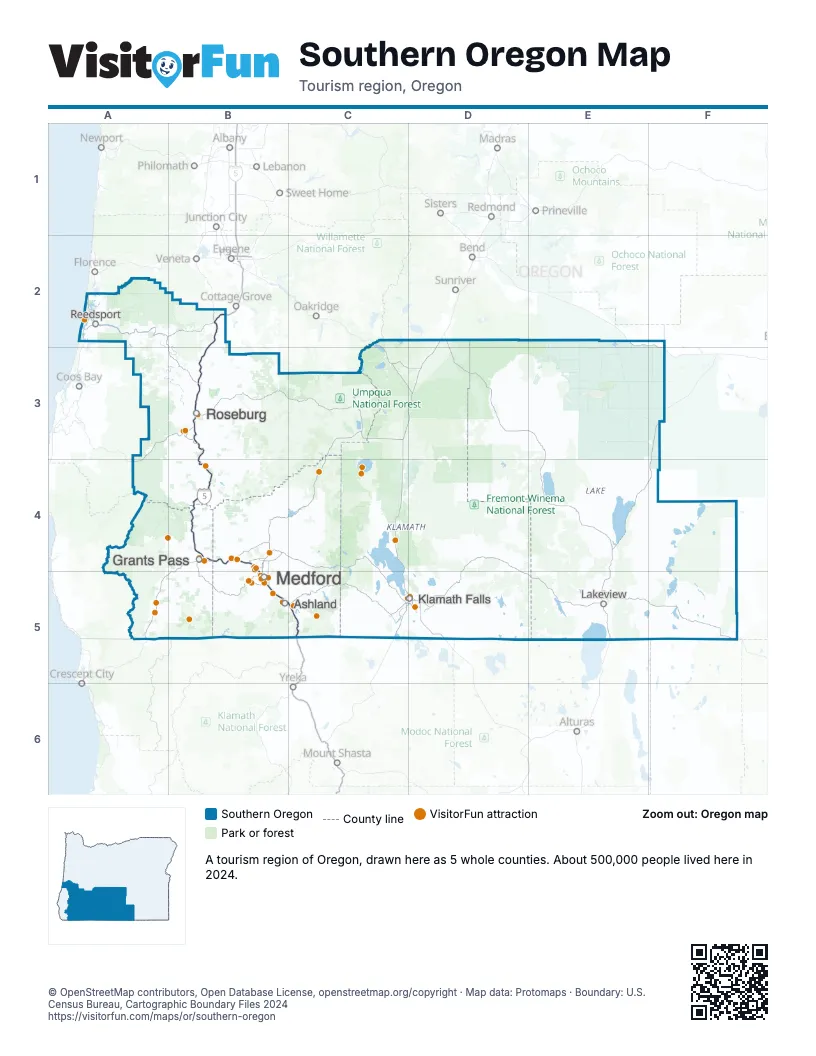
Highway index of Southern Oregon
Each highway on the sheet and the grid squares it crosses.
- I-5B2, B3, B4, B5, C5
- OR 99B2, B3, B4
- OR 138B3
Things to do on the Southern Oregon map
- Britt Music & Arts Festival
- Crater Lake National Park
- Crater Lake Zipline
- Morrison's Rogue Wilderness Lodge
- Oregon Shakespeare Festival
- Wildlife Safari
- Abacela Vineyards & Winery
- Applegate Wine Trail
- Ashland Food Co-op
- Belle Fiore Winery
- Bravo Outings
- Camelot Theatre
- Cascade-Siskiyou National Monument
- Children's Museum of Southern Oregon
- Crater Lake Trolley
- Crater Rock Museum
- Dancin Vineyards
- Del Rio Vineyards
- Escape Ashland
- Gino's Cafe and Sports Bar
- Great Cats World Park
- Hellgate Jetboat Excursions
- Irvine & Roberts Vineyards
- Jacksonville Oregon Wine Trail
- Kla-Mo-Ya Casino
- Klamath Art Association Gallery
- Klamath County Museum
- Ko-Kwel Casino Resort Medford
- Morrisons Rogue Wilderness Adventures
- Oregon Caves National Monument & Preserve
- Oregon Dunes National Recreation Area
- Rogue Creamery
- Rogue Rafting Company
- Rogue Valley Family Fun Center
- Rogue Valley Mall
- Rogue Valley ZipLine Adventures
- RoxyAnn Winery
- Southern Oregon Guild Gallery
- Southern Oregon Lavender Trail
- Tanker 61 Memorial Wildfire Learning Center
- The Glass Forge Gallery & Studio
- The Village at Medford Center
- True Lavender Collective
- Umpqua Valley Wine Trail
- Upper Rogue Wine Trail
- Wild Bee Honey Farm
Places on the map
- Ashland
- Grants Pass
- Klamath Falls
- Lakeview
- Medford
- Reedsport
- Roseburg
Next to Southern Oregon
- North Coast
- Shasta Cascade
- Reno-Tahoe Territory
- Central Oregon map
- Eastern Oregon map
- Oregon Coast map
- Willamette Valley map
© OpenStreetMap contributors, Open Database License, openstreetmap.org/copyright · Map data: Protomaps · Boundary: U.S. Census Bureau, Cartographic Boundary Files 2024















