

Oregon map
Coos Bay map
About 15,801 people live here (Census Bureau, 2024 estimate). The sheet's index lists 300 streets; Ocean Boulevard Southeast, Newmark Avenue and Lakeshore Drive cross the most grid squares. Things to do inside the boundary: Oregon's Adventure Coast (Coos Bay, North Bend & Charleston).
Open the map (PDF, US Letter)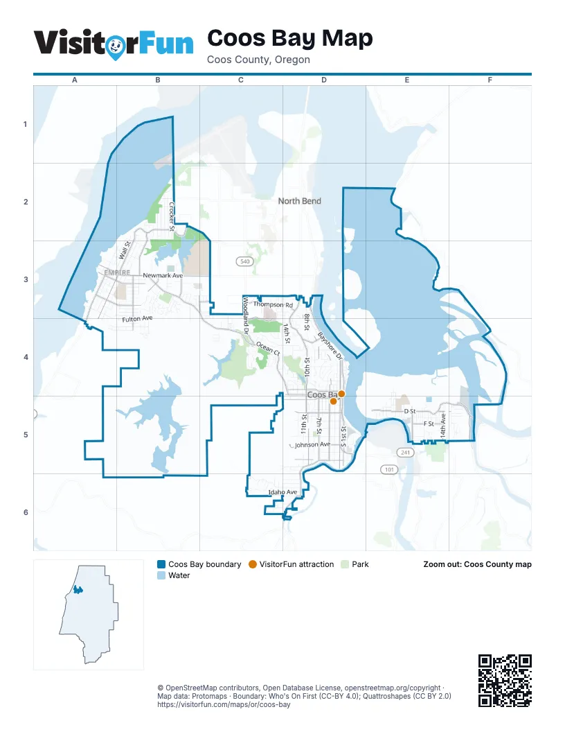
Street index of Coos Bay
Each street on the sheet and the grid squares it crosses.
- Newmark AvenueA3, B3, C3
- North Bayshore DriveD3, D4
- South BroadwayD4, D5
- South 1st StreetD5
- South Empire BoulevardA3, A4
- North BroadwayD4
- Evans BoulevardD5
- South Bayshore DriveD4, D5
- Oregon Coast HighwayD5
- Cape Arago HighwayA4
- Ocean Boulevard SoutheastB3, C3, C4, D4
- South 7th StreetD4, D5
- Anderson AvenueD5
- Commercial AvenueD4
- Ocean Boulevard NorthwestB3
- Coos River RoadE5, F5
- Woodland DriveC3, C4
- Central AvenueD4
- D StreetE5, F5
- 6th AvenueE5
- North 7th StreetD4
- Coos River HighwayF5
- Newport LaneE5
- East Bay RoadF4
- Lakeshore DriveB2, C2, B3
- Southwest BoulevardD5, D6
- Koos Bay BoulevardD3, D4
- South 4th StreetD4, D5
- South 10th StreetD4, D5
- Johnson AvenueD5
- North 10th StreetD3, D4
- Pacific AvenueA3, B3, C3
- South Morrison StreetB3, B4
- Thompson RoadC3, D3
- Michigan AvenueA3, B3
- South Wasson StreetA3, B3, A4
- Ross Inlet RoadF5
- Elrod AvenueD5
- West Lockhart AvenueD5
- North Wasson StreetB3
- F StreetE5
- 14th AvenueE5
- Hospital WayC3, C4
- North Morrison StreetB2, B3
- North 4th StreetD4
- Laclair StreetB3
- West D StreetE5
- Wallace StreetB3
- 34th StreetB3, C3
- North Schoneman StreetB3
- Walnut AvenueB3, C3
- Isthmus Heights RoadE5
- North 8th StreetD3, D4
- South 2nd StreetD4, D5
- California AvenueC6, D6
- North 14th StreetD3, D4
- Fulton AvenueA3, B3, B4
- Ingersoll AvenueD5
- South 5th StreetD4, D5
- South 11th StreetD4, D5
- Juniper AvenueC4, D4
- South Marple StreetA3, A4
- E StreetE5
- South Cammann StreetA3, B3, A4
- Idaho AvenueC6, D6
- North Front StreetD4
- Crocker StreetB2
- Fenwick StreetB2
- 9th AvenueE5
- Madison StreetB3, B4
- South Wall StreetA3
- Sanford StreetB2
- Kentucky AvenueA4, B4
- North Cammann StreetB2, B3
- North 6th StreetD4
- North 2nd StreetD4
- North Wall StreetB2, A3, B3
- North Marple StreetB2, A3, B3
- Timberline DriveC4
- South 8th StreetD4, D5
- Date AvenueD4
- Ocean CourtC4
- North Main StreetB3
- Hemlock AvenueD4
- Augustine StreetB2
- North 12th StreetD3, D4
- Radar RoadB3
- Myrtle AvenueC4, D4
- Telegraph DriveD4
- Noble AvenueA3, B3
- Hall AvenueD5
- Kruse AvenueD5
- Webster AvenueA3, B3
- North 15th StreetC3, C4
- Golden AvenueD5
- North 16th StreetC3, C4
- Park AvenueD4
- North 9th StreetD4
- Ackerman StreetB3
- Embarcadero CircleB3
- Schetter AvenueA3, B3
- Cedar AvenueC4, D4
- Pine AvenueC4, D4
- North Empire BoulevardA3, B3
- Pennsylvania AvenueC6, D6
- Marshall AvenueA4, B4
- Forest Hills DriveC4
- Seagate StreetB2
- I StreetE5, F5
- Oakway DriveC4
- Harris AvenueA3, B3
- Highland AvenueD4
- Kingwood AvenueC4, D4
- Cottonwood AvenueC4
- Lindberg AvenueB3, C3
- South 12th StreetD5
- 2nd AvenueE4, E5
- South 9th StreetD4, D5
- Minnesota AvenueC5, D5
- Market AvenueD4
- Montgomery AvenueA3, B3
- Blanco AvenueB3
- North 19th StreetC3, C4
- Shorepines AvenueB3
- South 6th StreetD4, D5
- North 11th StreetD3, D4
- 1st AvenueE4, E5
- West Park RoadwayD4
- 16th AvenueF5
- Teakwood AvenueC3, D3
- Salmon AvenueB3
- 4th AvenueE5
- North 13th StreetD4
- 17th AvenueF5
- Virginia AvenueB2
- Taylor AvenueB2, B3
- Arago AvenueB3
- 10th AvenueE5
- Garfield AvenueB3
- South Schoneman StreetB3
- Pacific LoopC3
- Fillmore StreetB3, B4
- Yew StreetB3, C3, D3
- Idaho DriveC6
- Oregon AvenueD6
- East Johnson AvenueD5
- Donnelly AvenueD5
- South Front StreetD5
- Ferguson AvenueD5
- North 3rd StreetD4
- Washington AvenueD6
- Shorepines VistaB3
- Puerto Vista DriveB3
- North 4th CourtD4
- Lindy LaneB3, B4
- Fir AvenueD4
- Norman AvenueB3
- Birch AvenueD4
- Village Pines DriveB3
- South Main StreetA3, B3
- 7th AvenueE5
- 8th AvenueE5
- Hull StreetB3
- Prefontaine DriveB3, B4
- Fink StreetE5
- Montana AvenueD6
- 8th CourtE5
- 26th StreetC3, C4
- Merchant StreetE5
- Alder AvenueD4
- Redwood AvenueD3, C4, D4
- Village Pines AvenueB3
- South 17th StreetC6
- East Park RoadwayD4
- East College WayC3
- Seagate AvenueB2
- 1st CourtE4, E5
- 3rd CourtE5
- H StreetE5
- Margaretta StreetB2
- Pacific DriveB3
- Shorepines DriveB3
- Shorepines PlaceB3
- 25th StreetC3, C4
- Lincoln RoadC4
- South College WayB3, C3
- 12th AvenueE5
- Curtis AvenueD5
- Flanagan AvenueB3
- Maryland AvenueB3
- North 17th StreetC3, C4
- Maxwell StreetB2
- South 28th CourtC4
- 18th AvenueF5
- Ocean TerraceC4
- Plymouth AvenueB4
- 13th AvenueE5
- 14th CourtE5
- Applewood DriveF5
- Lawnridge LoopC4
- Iowa AvenueC6
- North 10th CourtD4
- Seabreeze TerraceB2
- West College WayB3
- Inlet LoopB4
- Nautical LaneB4
- North 12th TerraceD4
- Canyon DriveE5
- South 15th StreetC6, D6
- 11th AvenueE5
- Illinois AvenueD6
- Greenwood AvenueD4
- Stillwater DriveB2
- Bennett AvenueD5
- East Entry WayC3
- North College WayB3, C3
- Bayview DriveF5
- Nutwood AvenueC4, D4
- M Entry WayC3
- Dakota AvenueD5
- Thomas AvenueB3
- Cedar DriveF5
- South 9th CourtD5
- Butler RoadC4
- Holland AvenueA3
- South 16th StreetC6
- Underwood AvenueC3, D3
- Signal WayD4
- 10th CourtE5
- North 5th StreetD4
- 5th AvenueE5
- Merrill StreetB3
- Whitty StreetE5
- North 7th CourtD4
- Sandpiper DriveC3
- Vine AvenueB3, D3
- 35th StreetB3
- Neese StreetB3
- Evergreen DriveC4
- South 19th StreetC6
- 8th TerraceD4
- Filbert StreetF5
- North 13th CourtD3, D4
- Ivy AvenueD4
- Dunn StreetB3
- Tideview TerraceB2
- 15th StreetE5
- B StreetE5
- Wisconsin AvenueA4
- Anderson LaneC5
- 28th StreetC4
- 12th CourtE5
- South 13th StreetD6
- North 3rd CourtD4
- Hillside CourtD4
- Laurel AvenueD4
- Spruce AvenueC3, D3
- Village Pines TerraceB3
- Jackson AvenueA3, B3
- Jackson StreetE5
- North 15th CourtC3
- Shorepines HeightsB3
- John AvenueB2
- Pennsylvania PlaceC6
- Elm AvenueD4
- Saint John StreetB2
- South Mill StreetA3
- Knott TerraceC4
- Jefferson StreetA4
- Hayes DriveC2
- Lakewood LaneB2
- Milligan AvenueB3
- Vanderhoof LaneF5
- Kinney RoadC3
- North 2nd CourtD4
- Evergreen StreetF5
- Leaf TerraceC4
- West Hills BoulevardC4
- East Lockhart AvenueD5
- 6th CourtE5
- C StreetE5
- South 21st StreetC6
- 7th CourtE5
- Brule StreetB3
- Twig TerraceC4
- 33rd StreetC3
- Chickses StreetB2
- Marino DriveB3
- 18th StreetC6
- Chickses DriveB2
- Clay StreetA3, B3
- Harbor View DriveE5
- Old Wireless LaneD6
- South 20th StreetC6
- Village Pines WayB3
- 13th CourtE5
- 32nd StreetC3
- G StreetE5
- North 20th StreetC4
- North 7th RoadD4
Things to do on the Coos Bay map
Places on the map
- 7 Devils Brewing Co. Waterfront Alehouse
- Ace Hardware
- Aspen Lace
- Bahama Buds
- Bay Area Hospital
- Bayshore Auto & RV Repair
- Bi-Mart
- Boardwalk Park
- C.J. O'Neill Glass and Radiator
- Cascade Farm and Outdoor
- CGX
- Chevron
- Coast Guard Exchange
- Coos Art Museum
- Coos Bay Fire Station #1
- Coos Bay Public Library
- Coos History Museum
- Eastside Post Office
- Eastside School
- Edgewater Inn
- Empire Post Office
- Face Rock Creamery
- Family Center and Child Care
- Farr's True Value Hardware
- Fred Meyer
- Fred Meyer Gas
- Lake Merritt
- Lower Empire Lake
- Lucky Loggers RV Park
- Millicoma Intermediate School
- Mingus Park
- Ocean View Memorial Gardens
- Radar Hill
- Red Lion Hotel Coos Bay
- Sunset Middle School
- Telegraph Hill
- Upper Empire Lake
- Upper Pony Creek Reservoir
- Walmart Supercenter
Next to Coos Bay
- North Bend
© OpenStreetMap contributors, Open Database License, openstreetmap.org/copyright · Map data: Protomaps · Boundary: Who's On First (CC-BY 4.0); Quattroshapes (CC BY 2.0)















