

Oregon map
Coos County map
About 64,326 people live here (Census Bureau, 2024 estimate). The sheet's index lists 300 streets; Oregon Coast Highway, State Highway 42 and Coos Bay-Roseburg Highway cross the most grid squares. Things to do inside the boundary: Oregon's Adventure Coast (Coos Bay, North Bend & Charleston) and Spinreel Dune Buggy & ATV Rentals.
Open the map (PDF, US Letter)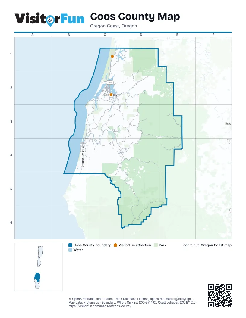
Maps inside Coos County
1 map inside, from the street map of Coos County down.
Street index of Coos County
Each street on the sheet and the grid squares it crosses.
- Oregon Coast HighwayC1, C2, B3, C3, B4, B5
- State Highway 42C3, C4, D4, E4, E5
- Coos Bay-Roseburg HighwayC3, C4, D4, E4
- Seven Devils RoadC2, C3
- Cape Arago HighwayB2, C2, B3
- Coquille-Bandon HighwayC3, B4, C4
- State Highway 42 SouthC3, C4
- West Beaver Hill RoadC3
- Sherman AvenueC2
- Sheridan AvenueC2
- Newmark AvenueC2
- North Bayshore DriveC2
- Newmark StreetC2
- Tremont AvenueC2
- Maryland AvenueC2, C4, D4
- 8th StreetC2, C4
- 2nd Street SoutheastB4
- Newport LaneC2
- South BroadwayC2
- South 1st StreetC2
- South Empire BoulevardC2
- North BroadwayC2
- South Adams StreetC3
- West Main StreetC3
- Evans BoulevardC2
- Mullen StreetC2
- South Bayshore DriveC2
- Roseburg RoadC4
- North Bank LaneB3, C3, C4
- Powers HighwayC4, D4, D5
- Lampa LaneC4
- Coos River HighwayC2, D2
- East Bay RoadC2
- Coos Sumner LaneC3, D3
- Libby LaneC2
- Ross Inlet RoadC2, C3
- Olive Barber RoadC2, C3
- Spruce StreetC2, C4, D4, D5
- North 8th StreetC1, C2
- Virginia AvenueC2
- Ocean Boulevard SoutheastC2
- Shinglehouse RoadC2
- East Beaver Hill RoadC3
- Broadway AvenueC2
- 1st AvenueC2, D5
- West Central BoulevardC3
- South 7th StreetC1, C2
- Coos River RoadC2, D2
- Central AvenueC2
- Anderson AvenueC2
- North Central BoulevardC3
- Woodland DriveC1, C2
- Commercial AvenueC2
- D StreetC2
- Ocean Boulevard NorthwestC2
- Airport WayC1
- East 2nd StreetC3
- Highway 242C4
- North Bank RoadC3
- North 7th StreetC1, C2
- 6th AvenueC2
- North Adams StreetC3
- Poplar StreetD5
- Edward RoadC2
- Walker LaneC2
- Sitkum LaneD3, E3, C4, D4
- Fairview RoadD2, C3, D3
- Forest Road 33D5, D6
- Burnt Ridge RoadE3
- National Forest Development Road 3348D5, E5, D6
- Weaver Creek RoadE4
- West Fork-Millicoma RoadD1, D2
- Lee Valley RoadD3, C4, D4
- East Fork Millicoma RoadD2
- Dement Creek RoadC4, C5
- South Coos River LaneC2, D2
- Sitkum-County Line RoadE3, E4
- Lone Pine LaneD3
- Old Broadbent RoadC4
- Catching Slough RoadC2, C3
- Middle Creek RoadD3
- Daniels Creek RoadD2, D3
- Fishtrap RoadC3, C4
- Forest Road 3348D6
- North Lake RoadC1, D1
- Kentuck Way LaneC2, D2
- Bear Creek RoadC4
- Old Wagon RoadC2, C3
- Two Mile LaneB4, C4
- South Coos River RoadD2
- Shutters Landing LaneC1
- Fat Elk RoadC3, C4
- Rosa RoadB4
- North Bay RoadC2
- Powers South RoadD5
- Trans Pacific ParkwayC2
- North Fork RoadC4, D4
- Beach Loop RoadB4
- Round Lake DriveB3, C3
- Fairview Sumner LaneD3
- Wildwood DriveC1
- Horsfall RoadC2
- Glenn Creek RoadD2
- Crown Point RoadC2, C3
- Wildwood RoadC1
- Kelsey Mule RoadE5
- Prosper Junction RoadB4, C4
- Ash StreetC2, C4
- Isthmus Heights RoadC2
- Arago-Fishtrap RoadC4
- Croft Lake LaneB4
- Randolph Trail RoadC3
- Whiskey Run RoadB3, C3
- Bill Creek LaneB4, C4
- Green Acres LaneC3
- Coos Bay Wagon RoadD3
- Maple StreetC2, C4, D4
- West Catching RoadC2
- Shelley LaneC3
- Pleasant Valley RoadC4
- Oak StreetC2, C4
- North Bay DriveC2
- Riverside Drive NortheastB4
- Jordan Cove RoadC2
- Arago Valley LaneC4
- West Randolph LaneC3
- Lakeshore DriveC2
- Red Dyke RoadC2
- Fahy RoadB3, C3
- Tom Smith RoadC3, C4
- Fir StreetC2, D5
- Southwest BoulevardC2
- 11th Street SouthwestB4
- Crest Acres RoadC3
- Upper Loop RoadC3
- Randolph RoadC3
- Spinreel RoadC1
- Flanagan RoadC2
- Connecticut AvenueC2
- South 4th StreetC1, C2
- Koos Bay BoulevardC2
- Stringtown LaneC4
- Millington Frontage RoadC2
- Beach Loop Drive SouthwestB4
- North 10th StreetC1, C2
- South 10th StreetC2
- Wallace RoadC2
- Coos Head RoadC2
- Beaver Loop RoadC1
- Johnson AvenueC2
- Robison LaneC4
- Brussells StreetC2
- Coal Bank LaneC2
- Seabird DriveB4
- Pacific AvenueC2
- 11th Street SoutheastB4
- South Morrison StreetC2
- 16th StreetC2, C4
- Meade AvenueC2
- Michigan AvenueC2, B4
- Thompson RoadC2
- South Wasson StreetC2
- South 8th StreetC1, C2
- Washington AvenueC2
- 1st Street SoutheastB4
- Elrod AvenueC2
- South Barview RoadC2
- Colorado AvenueC2
- Pacific StreetC2
- Boat Basin RoadC2
- 4th AvenueC2, D5
- Harris StreetC4
- West Lockhart AvenueC2
- Bay Park LaneC2
- Grinnell LaneC2
- Fillmore Avenue SoutheastB4
- Isthmus Heights CutoffC2
- 4th StreetB4, C4
- Fruitdale RoadC2
- 4th Street SouthwestB4
- Hollywood LaneC2
- 17th StreetC2
- Cross Road LaneC4
- Pony Creek RoadC2
- Wilshire LaneC2
- North Wasson StreetC2
- Ranch LaneC1
- Bastendorff RoadC2
- Bastendorff Beach RoadC2
- Jetty Road SouthwestB4
- Green Acres RoadC3
- F StreetC2
- Travis LaneC2
- North Birch StreetC3
- Saunders Lake Fr Road No 1C1
- Chicago Avenue SoutheastB4
- North 4th StreetC1, C2
- 14th AvenueC2
- Delaware Avenue SoutheastB4
- Hospital WayC2
- Edison Avenue SouthwestB4
- North Morrison StreetC2
- Harlem Street SoutheastB4
- 3rd StreetC2, C3, C4
- Penny RoadC2
- Kellogg LaneC2
- Airport LaneC2
- Harrison AvenueC2, B4
- Ocean Drive SouthwestB4
- Vermont AvenueC2
- Laclair StreetC2
- Robertson LaneC2
- West Side RoadC4
- Shelley RoadC3
- West D StreetC2
- Wallace StreetC2
- Saunders Lake Fr Road No 3C1
- 7th Street SouthwestB4
- Wildahl RoadC2
- Maple Leaf StreetC2
- 34th StreetC2
- Island DriveC1
- North Schoneman StreetC2
- 12th StreetC2
- Myrtle Point-Sitkum RoadD3, D4
- Crannog RoadC1
- Aviation CourtC2
- Crowell LaneC2
- 1st Street SouthwestB4
- Ross InletC2
- Walnut AvenueC2
- Upper LoopC3
- Noah RoadC2
- Sitkum RoadD3
- West 2nd StreetC3
- Wtc 5000 RoadE3
- Lakeside Frontage RoadC1
- Burnt Mountain Access RoadD3, E3
- Rock Creek RoadD4, D5
- Forest Road 5520D6
- Myrtle Creek RoadD4, D5
- National Forest Development Road 3358D5, D6
- Big Creek RoadD1, D4
- Salmon Creek RoadC5, D5
- Mill Creek RoadD5
- Catching Creek LaneC4
- Elk Mountain Loop RoadD3, D4
- Haynes Way LaneC1, D1, C2
- National Forest Development Road 3353D6
- Marlow Creek RoadD1, D2
- McKinley LaneD3
- Sandy Creek RoadD4, E4
- Peacock LaneD4
- Elk Creek RidgeD4
- Weekly Creek RoadD4
- Forest Road 3358D6
- Weyerhaeuser LaneD2
- National Forest Development Road 3363D5, D6
- Templeton RoadC1, D1
- Upper Fourmile LaneB4, C4
- Cherry Creek MainlineD3
- Johnson Mountain RoadD5
- National Forest Development Road 240D5
- Morrison RoadC4
- Burnt Mtn TieE3
- Hall Creek LaneC4
- East Fork Bennett Creek RoadE3
- Rowland Ceek County RoadC5, D5
- Blue Ridge Lookout RoadD3
- Parkersburg RoadC3, C4
- Yellow Creek RoadD4, D5
- Jenkins Prairie RoadD4
- Burnt Creek RoadE3
- Stage RoadC1
- Landrith RoadD2
- National Forest Development Road 010D5, D6
- Dora Ridge RoadD3, D4
- National Forest Development Road 220D6
- Gold Brick RoadD3, D4
- North WayC1, C2
- Catching Creek RoadC4, C5
- National Forest Development Road 3040D5
- Stian Smith RoadD2
- Jones Court RoadD4
- Bethel Mountain LaneB4, B5, C5
- Willanch WayC2
- Cawrse RoadE4
- Noah Butte RoadC2
- Larson WayC2, D2
- Brummit Creek RoadD3, E3
- Llewellen Creek RoadC4, D4
- Summerlin RoadD3, D4
- Skeeter Camp RoadE3
- Blm RoadD4
- Bullards Beach RoadB3, B4
- Ward Creek LaneC4
- Brady RoadD4
- Crosby RoadD4
- Gravelford RoadD4
- South Sumner RoadC3
Things to do on the Coos County map
Places on the map
- Bandon
- Bandon Beach
- Bandon Crossings Golf Course
- Bandon Dunes Golf Resort
- Bandon Marsh National Wildlife Refuge
- Bandon Sheep Ranch
- Bandon State Airport
- Bandon State Natural Area
- Bandon Trails
- Barview
- Bastendorff Beach
- Bastendorff Beach County Park
- Bastendorff Beach Day Use Area
- Beale Lake
- Bullards Beach State Park
- Bunker Hill
- Butterfield Lake
- Cape Arago State Park
- Clear Lake
- Coal Bank Slough
- Coos Bay
- Coos Golf Club
- Coquille
- Douglas-Fir Instant Study Area
- Elliott State Forest
- Fahys Lake
- Henderson Marsh
- Horsfall Lake
- Hundred Acre Wood
- Johnson Mill Pond
- Lake Merritt
- Lakeside
- Laurel Lake
- McKeown Reservoir
- Myrtle Point
- North Bend
- North Tenmile Lake
- Oregon Dunes National Recreation Area
- Powers
- Sandpoint Lake
© OpenStreetMap contributors, Open Database License, openstreetmap.org/copyright · Map data: Protomaps · Boundary: Who's On First (CC-BY 4.0); Quattroshapes (CC BY 2.0)















