

Oregon map
Curry County map
About 22,774 people live here (Census Bureau, 2024 estimate). The sheet's index lists 300 streets; Oregon Coast Highway, Sixes River Road and Gardner Ridge Road cross the most grid squares. Things to do inside the boundary: Curry Coast, Gold Beach and Jerry's Rogue Jets.
Open the map (PDF, US Letter)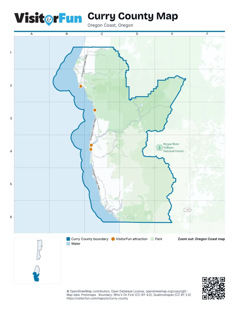
Street index of Curry County
Each street on the sheet and the grid squares it crosses.
- Oregon Coast HighwayB1, C1, B2, C2, C3, C4, C5, C6, D6
- South Bank Chetco River RoadC6, D6
- Ellensburg AvenueC4
- Chetco AvenueC6
- Oregon StreetB2
- Hunter Creek LoopC4
- Lower Harbor RoadC6
- 6th StreetB2, C4, C6
- Isaac Lee Patterson BridgeC4
- Carpenterville RoadC5, C6
- North Bank Rogue River RoadC3, C4
- Jerrys Flat RoadC3, C4
- Oceanview DriveC6
- Cape Ferrelo RoadC5
- Edson Creek RoadC3, C4
- 5th StreetB2, C4, C6
- Easy StreetC6
- Pacific AvenueC6
- West Benham LaneC6
- Pioneer RoadC6
- Oak StreetC6
- Wenbourne LaneC6
- Forest Road 33D2, C3, D3
- Forest Road 3680C4, D4
- Bear Camp RoadD3, E3
- Sixes River RoadD1, B2, C2, D2
- Langlois Mountain RoadC1
- Elk River RoadB2, C2
- North Bank Chetco River RoadD5, C6, D6
- Floras Creek RoadC1
- Winchuck River RoadC6, D6
- Forest Road 3313C3, C4
- Cedar Valley RoadC3, C4
- Agness-Illahe RoadD3
- Gardner Ridge RoadC5, D5, C6, D6
- Kelsey Mule RoadE2
- Cape Blanco RoadB1, B2
- Hunter Creek RoadC4
- Old Coast RoadC3, C4
- Ophir RoadC3
- Old County RoadC6
- Myers Creek RoadC4
- Airport RoadB1
- Rainbow Rock RoadC6
- Pistol River LoopC5
- Floras Lake LoopC1
- Coy Creek RoadC3
- Floras Lake RoadB1, C1
- Duley Creek RoadC6
- Nesika RoadC3
- Parkview DriveC6
- Hensley Hill RoadB2
- Port Orford Loop RoadB2
- Cape View LoopC4, C5
- Cemetery Loop RoadB2
- Wedderburn LoopC4
- Ransom StreetC6
- Railroad StreetC6
- Paradise Point RoadB2
- Hassett StreetC6
- Pedrioli DriveC6
- 3rd StreetC4, C6
- Dodge AvenueC6
- Shopping Center AvenueC6
- Port Orford HighwayB2
- Fern AvenueC6
- Marina Heights RoadC6
- Olsen LaneC6
- Hillside Acres RoadC3
- Pacific Heights RoadC6
- Mill Beach RoadC6
- Center StreetC6
- 9th StreetB2, C4
- East Hoffeldt LaneC6
- Dawson RoadC6
- 16218 West Hoffeldt LaneC6
- Arnold LaneC6
- Elk DriveC6
- Fifield StreetC6
- Ocean WayC4
- Coast Guard Hill RoadB2
- West Hoffeldt LaneC6
- Forest Road 4201E5
- Miner DriveC4
- Zimmerman RoadC6
- Walker Prairie RoadE2
- Forest Road 1107D5, D6
- Forest Road 1376D4, D5
- Forest Road 5325C2, D2
- Forest Road 1909D5
- Forest Road 5502C2
- Forest Road 1205D6
- Forest Road 3340D2, C3, D3
- Forest Road 3318D3, D4
- Forest Road 1703C4
- Lobster Creek RoadC3
- Grassy Knob RoadB2, C2
- Forest Road 3336D3
- Forest Road 150C2, C4, D4
- Forest Road 3353D2
- Forest Road 1983D6
- Forest Road 400D4
- North Fork Sixes River RoadC1, D1, D2
- Forest Road 3310C3, D3
- Forest Road 010D6
- North Bank Pistol River RoadC5
- Forest Road 3730D2, D3
- Forest Road 130C5, D5
- National Forest Development Road 5201C2
- Lewis Creek RoadC5, C6, D6
- Cate RoadD5
- Long Gulch RoadE2, E3
- Forest Road 310D4
- Peavine Ridge RoadD6
- China Mountain RoadC2
- Marial RoadE2
- Old Eckley RoadD1
- Saunders Creek RoadC4
- Hazel Camp RoadD5
- Grizzly Mountain RoadC4
- Forest Road 300D4
- Forest Road 3533C3
- Oak Flat RoadD3
- Forest Road 260C4, D4
- South Fork Floras Creek RoadC1
- Moore Mill RoadC1, C2
- Musser HillC6
- Silver Creek RoadC3, D3
- Forest Road 1503C4
- Dement Creek RoadC1
- Highlands DriveC2, C3
- Forest Road 3402C3
- County Highway 690C5
- Martin Ranch RoadC5
- Little South Fork Hunter Creek RoadC4
- Mount Emily RoadD6
- Hays Creek RoadD1
- McVay Creek RoadC6, D6
- Timeus Ranch RoadC5, C6
- South Crystal Creek RoadC1, B2, C2
- Mc Kenzie RoadB2
- Euchre Creek RoadC3
- Edson Creek Park RoadC2
- National Forest Development Road 040C2
- National Forest Development Road 080C2
- Alder Ridge RoadC5, C6
- Forest Road 070C4, D4
- Campbell RoadC6
- Hubbard Creek RoadB2, C2
- Sundown RoadD3, C5
- Arizona StreetB2
- Mateer RoadC4
- Forest Road 152C2
- Forest Road 060C3
- Wilderness RoadC5
- Miller Ranch RoadC3
- Carlton Creek RoadC1
- Cornett RoadC5, C6
- Mountain DriveC6
- Eggers RoadC5
- Vista DriveB2
- Whaleshead RoadC5
- Pacific View RoadC1
- Forest Road 1108D6
- South Bank Pistol River RoadC5
- Forest Road 4402-112E6
- Indian Hill RoadC3, C4
- Bull Gulch RoadC5
- Jackson StreetC1, B2
- Libby Creek RoadC3
- Bethel Creek RoadC1
- National Forest Development Road 5105C2
- Stonecypher RoadC1
- Spirit Ridge DriveC3, C4
- Ferry Creek Heights RoadC6
- 1st StreetC1, C4, C6
- Kimball Hill RoadC3
- Marine DriveC6
- Edson Creek TrailC3
- Crown TerraceC6
- 11th StreetB2, C4
- Harbor Hills HeightsC6
- Coho DriveC6
- Wilderness DriveC5
- Pelican Bay DriveC6
- Wildwood RoadC5
- 7th StreetB2, C4, C6
- Gardiner Ridge RoadD5
- Stage Coach RoadC5, C6
- Herford RoadB2, C2
- National Forest Development Road 070C2
- Skyview Ranch RoadC3
- Lakeshore DriveB1, B2
- Crabapple WayC4
- Dewey RoadB2
- North Fork Hubbard Creek RoadB2
- Greggs Creek RoadC3
- Bravo LaneC4, D6
- Burnt Ridge RoadD3
- Hunter Creek Heights RoadC4
- Oceanside DriveC4
- Napa LaneC6
- Noble DriveB2, C2
- Eighty Acres RoadC4
- Arizona Ranch RoadC3
- Henderson RoadC6
- County Highway 196B2
- Fir RoadB2, C2
- Huckleberry Ridge RoadC5
- Grouse LaneC1
- Adams RoadC3
- Eastwood LaneC6
- Bauer RoadC4
- Old Mill RoadB2
- Wharf StreetC6
- North Grizzly RoadC4
- Taylor Creek RoadC6
- Alder StreetC1, C6
- Boslee Butte RoadC5
- Idaho StreetB2
- Hall WayC6
- Bennet Butte RoadC1
- Winriver RoadD6
- Knapp RoadB2
- Jefferson StreetB2
- Tututni HollowC4
- Quarry RoadC4
- Park RoadB1, B2
- 8th StreetB2, C4
- Hounddog RoadC4
- National Forest Development Road 074C2
- Marina Heights LoopC6
- Deady StreetB2
- East Morton Creek RoadC1
- Emerald DriveC4
- County Highway 776C6
- Salmonberry RoadC6
- Byrdies LaneC5
- Childers RoadB2
- Memory LaneC6
- Bravo HeightsD6
- Spruce DriveC4, C6
- Lanz LaneC5
- Billings RoadD3
- Homestead WayC3, C4
- Indian Head LaneD6
- 2nd StreetC1, C4, C6
- North Fork Edson Creek TrailC3
- Burnt Hill RoadC5
- National Forest Development Road 081C2
- Woodruff LaneB1
- Thompson RoadC6
- Cape Sebastian Point RoadC4
- Miller LaneC3
- Agate Beach RoadB2
- King StreetB2, C6
- Airport WayC4
- 10th StreetB2, C4
- South Taylor Creek RoadC6
- Cranberry LaneB1
- Forest Road 4201-142E5
- Fern Ridge RoadC1
- Camellia DriveC6
- Ostenberg RoadC6
- Thimbleberry RoadC4
- 12th StreetB2
- Walker LaneC5
- Conn Creek RoadC4
- Moore StreetC4, C6
- Brookside DriveC5
- Indian Ridge RoadC4
- Spruce StreetC6
- Tuttle LaneC6
- 5200 RoadC1
- Silver Butte RoadB2
- Bluejay RoadC6
- Olympic RoadC5, C6
- 4th StreetC4, C6
- Brooks RoadC4
- California StreetB2
- Longacre Loop RoadC6
- 13th StreetB2
- Lone Ranch RoadC6
- Mountain RoadC4
- Ponderosa RoadC3
- Quail Mountain RoadC4
- National Forest Development Road 072C2
- Maple DriveC5, C6
- Washington StreetB2
- Ranch RoadC6
- County Highway 207B2
- Grandview DriveC6
- Bridgeview DriveC5
- Indian LaneC1
- Rhody DriveC6
- Old US Highway 101C6
- West Huckleberry Ridge RoadC5
- Bayview DriveC4, C6
- Cypress DriveC3
- Meadow LaneC1, C6
Things to do on the Curry County map
Places on the map
- Agate Beach
- Alfred A. Loeb State Park
- Arizona Beach
- Arizona Beach State Recreation Site
- Azalea Park
- Barley Beach
- Beachfront RV Park
- Blacklock Point Marine Conservation Area
- Brookings
- Brookings Airport
- Brookings Marine Research Area
- Cape Blanco Light Station
- Cape Blanco State Park
- Cape Sebastian State Scenic Corridor
- Chetco River
- Copper Salmon Wilderness
- Floras Lake
- Floras Lake State Natural Area
- Garrison Lake
- Gold Beach
- Gold Beach Municipal Airport
- Grassy Knob Wilderness
- Harbor
- Harris Beach State Park
- Humbug Mountain State Park
- Hunter Creek Beach
- Kalmiopsis Wilderness
- Meyers Creek Beach
- Oregon Islands National Wildlife Refuge
- Port Orford
- Port Orford Heads State Park
- Redfish Rocks Marine Protected Area
- Redfish Rocks Marine Reserve
- Salmon Run Golf Course
- Samuel H. Boardman State Scenic Corridor
- Sisters Rock State Park
- Sixes Beach
- Sporthaven Beach
- Whaleshead Beach
- Wild Rogue Wilderness
© OpenStreetMap contributors, Open Database License, openstreetmap.org/copyright · Map data: Protomaps · Boundary: Who's On First (CC-BY 4.0); Quattroshapes (CC BY 2.0)















