

Oregon map
Oregon map
Things to do inside the boundary: 1937 Steiner Log Church, 2Cs Vendor Mall and 7 Devils Brewing Co. Also on it: BLM Criterion Tract, Boardman Bombing Range and Cascade–Siskiyou National Monument. Just past the edge: Boise, Crescent City and Lewiston.
Open the map (PDF, US Letter)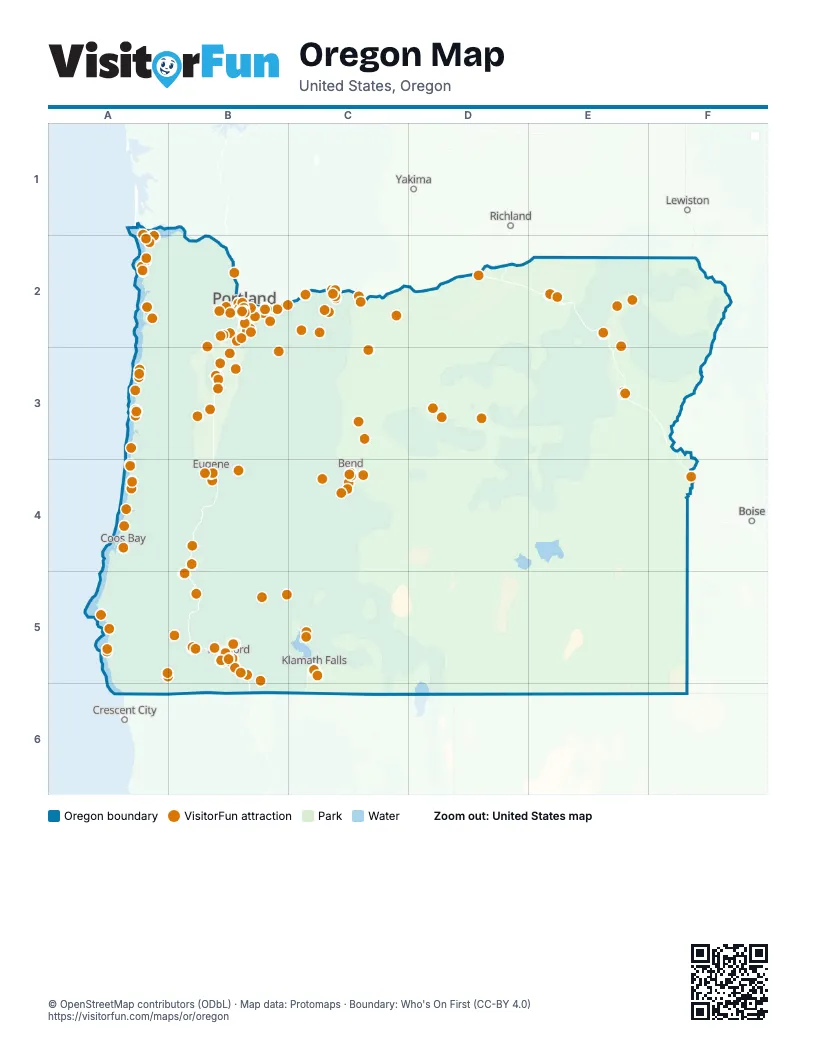
Maps inside Oregon
7 maps inside, from the street map of Oregon down.
Things to do on the Oregon map
- 1937 Steiner Log Church
- 2Cs Vendor Mall
- 7 Devils Brewing Co
- A Convenient Cycle
- Abacela Vineyards & Winery
- Albany
- Albany Historic Carousel and Museum
- Always Catchin Fishing Charters
- Applegate Wine Trail
- Arlene Schnitzer Concert Hall
- Around Portland Tours
- Ashland
- Ashland Chamber of Commerce & Travel Ashland
- Ashland Food Co-op
- Astoria Column
- Astoria-Warrenton
- Backstory Books & Yarn
- Bar Run Golf & RV Resort
- Belle Fiore Winery
- Bend
- Betsy & Iya
- Bike the Gorge
- Boardman
- Bonneville Lock and Dam
- Bravo Outings
- Britt Music & Arts Festival
- C&M Stables
- Camelot Theatre
- Cannon Beach
- Cape Perpetua Scenic Area
- Captain Kid Amusement Park
- Carriage House Lavender
- Cascade Locks
- Cascade Locks Historical Museum
- Cascade-Siskiyou National Monument
- Cascades Raptor Center
- Cedartree Hotel
- Central Oregon
- Children's Museum of Southern Oregon
- Chiloquin
- Columbia Gorge Discovery Center & Museum
- Columbia Gorge Hotel & Spa
- Columbia Gorge Tourism Alliance
- Columbia River Gorge Waterfall Tour
- Columbia River Maritime Museum
- Corvallis
- Cove Palisades Resort & Marina
- Crafty Wonderland
- Crater Lake Trolley
- Crater Lake Zipline
- Crater Rock Museum
- Creo Chocolate
- Curry Coast
- Dancin Vineyards
- Del Rio Vineyards
- Deschutes Brewery Portland Public House
- Deschutes Historical Museum
- Deschutes River Adventures
- Draper Girls Country Farm
- Eagle Cap Excursion Train
- Eagle Point
- Eastern Oregon
- Ebike Multnomah Falls
- Ecola State Park
- EcoTours of Oregon
- ECOVIBE Alberta Street
- Enchanted Forest
- End of the Oregon Trail Interpretive Center
- Englewood Forest Festival
- Envi Adventures
- Escape Ashland
- Eugene Saturday Market
- Eugene Science Center
- Fiber Rhythm Craft & Design
- Florence Chamber of Commerce Visitor Center
- Forest Park
- Fort Clatsop
- Fort Stevens State Park
- Four Rivers Cultural Center
- Freakybuttrue Peculiarium
- Gallery Calapooia
- Gallery Without Walls
- Garibaldi Charters
- Gateway to the Gorge Visitor Center
- Geiser Grand Hotel
- Gino's Cafe and Sports Bar
- Gold Beach
- Gorge Sail Ventures
- Grants Pass
- Gray Line of Portland
- Great Cats World Park
- Gresham
- Hatfield Marine Science Center Visitor Center
- Haystack Rock
- Heceta Head Lighthouse
- Hellgate Jetboat Excursions
- Heritage Station Museum
- High Desert Food Trail
- High Desert Museum
- High Life Adventures
- Hillsboro Visitor Information Center
- Historic Willamette District
- Hood River
- Hood River Fruit Loop
- Hopscotch Portland
- Huber's Cafe
- International Rose Test Garden
- Irvine & Roberts Vineyards
- Jacksonville
- Jacksonville Oregon Wine Trail
- Jerry's Rogue Jets
- John Day Fossil Beds National Monument
- Kla-Mo-Ya Casino
- Klamath Art Association Gallery
- Klamath County
- Klamath County Museum
- Ko-Kwel Casino Resort Medford
- Lake Of The Woods Resort
- Lake Oswego Festival of the Arts
- Lan Su Chinese Garden
- Lane County
- Leach Botanical Garden
- Lincoln City
- Lincoln City Glass Center
- Lincoln City Outlets
- Lost Plate Food Tours Portland
- Mariner Square
- Mark Spencer Hotel
- McKenzie River Lavender
- McMenamins Crystal Hotel
- McMenamins Edgefield
- Medford
- Minam Store
- Mitchell
- Morrison's Rogue Wilderness Lodge
- Morrisons Rogue Wilderness Adventures
- Mount Hood Railroad
- Mt. Bachelor
- Mt. Hood Territory
- Mtn. View RV Park
- New Renaissance Bookshop
- Newberg
- Newberry National Volcanic Monument
- Newport
- Newport Visitor Information Center
- North American Aerospace Museum
- North American Bigfoot Center
- Oblation Papers & Press
- Oregon Caves National Monument & Preserve
- Oregon Cheese Trail
- Oregon Coast
- Oregon Coast Aquarium
- Oregon Coast Scenic Railroad
- Oregon Dunes National Recreation Area
- Oregon Historical Society
- Oregon Jewish Museum and Center for Holocaust Education
- Oregon Museum of Science and Industry (OMSI)
- Oregon Shakespeare Festival
- Oregon State Capitol
- Oregon Zoo
- Oregon's Adventure Coast (Coos Bay, North Bend & Charleston)
- Packer Orchards
- Painted Hills
- Park Lane Suites & Inn
- Peak Tours and Transit
- Pendleton
- Pendleton Underground Tours
- Pendleton Woolen Mills
- Pittock Mansion
- Portland
- Portland Aerial Tram
- Portland Art Museum
- Portland By Mouth
- Portland Food Cart Pods
- Portland Japanese Garden
- Portland Rose Balloons
- Portland Saturday Market
- Portland Spirit
- Powell's City of Books
- Powerland Heritage Park
- Prehistoric Gardens
- Puzzle Effect Bend
- Redfish Music Festival
- River Drifters
- Rogue Creamery
- Rogue Rafting Company
- Rogue Valley Family Fun Center
- Rogue Valley ZipLine Adventures
- Roseburg
- RoxyAnn Winery
- SAGE Center
- Sand Dunes Frontier
- Sandland Adventures
- Sea Lion Caves
- Seaside
- Seven Feathers Casino Resort
- Sherman County Historical Museum
- Silverton Chamber of Commerce & Visitor Center
- Sinister Coffee and Creamery
- Skeleton Key Odditorium
- Smith Rock State Park
- South Coast Tours
- Southern Oregon
- Southern Oregon Coast
- Southern Oregon Guild Gallery
- Southern Oregon Lavender Trail
- Spinreel Dune Buggy & ATV Rentals
- Sumpter Valley Railroad
- Sun Country Tours
- Sunriver Area Chamber of Commerce
- Sutherlin
- Swan Island Dahlias
- Tanker 61 Memorial Wildfire Learning Center
- Tender Loving Empire
- The Dalles
- The Fruit Company Museum & Factory Store
- The Glass Forge Gallery & Studio
- The Sandy Jug
- The Village at Medford Center
- The Winchester Inn
- Third Wave Coffee Tours
- Tillamook
- Timberline Lodge
- Tipsy Scoop Portland
- Travel Baker County
- Travel Salem Visitor Center
- Triangle Wine Country Tours
- True Lavender Collective
- Tualatin Valley
- Umpqua Valley Wine Trail
- Union County
- Union County Museum
- Union Creek Resort
- Upper Rogue Wine Trail
- Vista Balloon Adventures
- Washington Park
- Weasku Inn
- Western Antique Aeroplane and Automobile Museum
- Whale Research EcoExcursions
- Wild Bee Honey Farm
- Wildhorse Resort & Casino
- Wildlife Safari
- Wildwood Adventures
- Willamette Jetboat Excursions
- Willamette Valley
- Willamette Valley Vineyards
- Wooden Shoe Tulip Farm
- World Forestry Center
- Yellow Castle Bricks
Places on the map
- BLM Criterion Tract
- Boardman Bombing Range
- Cascade–Siskiyou National Monument
- Clackamas Wilderness
- Clatsop State Forest
- Cottonwood Canyon State Park
- Crater Lake National Park
- Crooked River National Grassland
- Deschutes National Forest
- Deschutes River State Scenic Waterway
- Eagle Cap Wilderness
- Elliott State Forest
- Fremont-Winema National Forest
- Gilchrist State Forest
- Grande Ronde Wild And Scenic River
- Hart Mountain National Antelope Refuge
- Hells Canyon National Recreation Area
- John Day Fossil Beds National Monument
- Kalmiopsis Wilderness
- Klamath Marsh National Wildlife Refuge
- Lewis and Clark National Historical Park
- Lower Deschutes River (BLM)
- Lower Deschutes Wildlife Area
- Malheur National Forest
- Malheur National Wildlife Refuge
- Mark O. Hatfield Wilderness
- Mount Hood National Forest
- Mount Hood National Recreation Area
- Mount Hood Wilderness
- Mount Jefferson Wilderness
- Mount Thielsen Wilderness
- North Fork John Day Wilderness
- Ocean Shore State Recreation Area
- Ochoco Mountains
- Ochoco National Forest
- Oregon Islands National Wildlife Refuge
- Pine Creek Conservation Area
- Rincon Wilderness Study Area
- Roaring River Wilderness
- Rogue River-Siskiyou National Forest
Next to Oregon
- Boise
- Crescent City
- Lewiston
- Richland
- Vancouver
- Yakima
© OpenStreetMap contributors (ODbL) · Map data: Protomaps · Boundary: Who's On First (CC-BY 4.0)