

Oregon map
McMinnville map
About 35,255 people live here (Census Bureau, 2024 estimate). The sheet's index lists 300 streets; Northeast Pacific Highway West, Southwest Goucher Street and Northwest Horizon Drive cross the most grid squares. Things to do inside the boundary: North American Aerospace Museum.
Open the map (PDF, US Letter)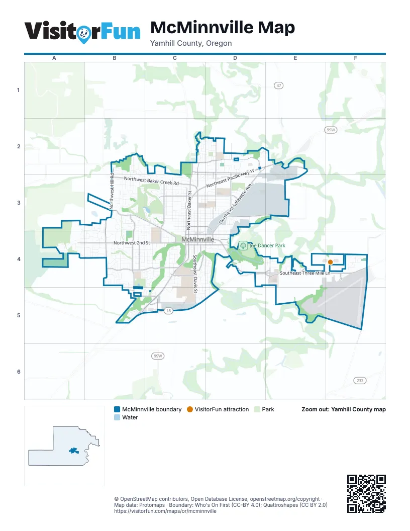
Street index of McMinnville
Each street on the sheet and the grid squares it crosses.
- Southeast Three Mile LaneD4, E4, F4
- Northeast Pacific Highway WestD2, E2, C3, D3
- Northeast Baker StreetC2, C3, C4
- Southwest Baker StreetC4, C5
- Northeast Adams StreetC3, C4
- Salmon River HighwayB5, C5
- Northeast 5th StreetC4, D4
- Northeast 3rd StreetC4, D4
- East McMinnville BypassD4, C5, D5
- West McMinnville BypassB5, C5
- Northeast Johnson StreetD2, D3, D4
- Southeast Baker StreetC4
- Southeast Adams StreetC4
- Northeast Three Mile LaneD4
- Northwest 2nd StreetA4, B4, C4
- Northwest Hill RoadB2, B3, B4
- Northeast Lafayette AvenueD2, D3, D4
- Northwest Baker Creek RoadB3, C3
- Southwest Cypress StreetB4
- Northeast 2nd StreetC4, D4
- Southwest Old Sheridan RoadB5, C5
- Southwest Cypress LaneB4, B5
- Northeast Baker Creek RoadC3
- Westside RoadC2
- Northeast Cumulus AvenueD4, E4
- Northeast Evans StreetC2, C3, C4
- Northeast Riverside DriveE2, D3, E3
- Northwest Wallace RoadB3, C3, C4
- Northeast McDonald LaneD2, D3
- Southwest Fellows StreetB4, C4
- Northwest Michelbook LaneC3, C4
- Northeast 27th StreetC2, D2
- Southeast Davis StreetC4, C5
- Northeast 19th StreetC3, D3
- Southeast Airport RoadF4, F5
- Northeast Grandhaven StreetD2
- Northeast 1st StreetC4, D4
- Northeast McDaniel LaneD2, D3
- Southwest Booth Bend RoadC5
- Northwest Cypress StreetB3, B4
- Northeast 8th StreetC3, D3, D4
- Southwest Agee StreetB4
- Northwest 19th StreetC3
- Southeast Ford StreetC4
- Southeast Norton LaneE4
- Southeast Stratus AvenueD4, E4
- Southwest Hill RoadB4
- Northeast Grandhaven DriveD2
- Southeast Booth Bend RoadC5
- Southeast Riverside DriveE3
- Southwest Linfield AvenueC4
- Northeast Norton LaneE4
- Southeast Loop RoadF4
- Southeast Cirrus AvenueF4
- Southeast Linfield AvenueC4
- Southeast College AvenueC4
- Northeast Burnett RoadC2, D2
- Northwest Burnett RoadC2
- Northwest Star Mill WayC4
- Northwest Meadows DriveB2, B3, B4
- Northeast Hembree StreetD2, D3
- Northwest Birch StreetC3, C4
- Southwest Redmond Hill RoadA4, B4
- Northeast Ford StreetC2, C3, C4
- Heather ManorC2, D2
- Southwest Westvale StreetB4
- Northeast Galloway StreetC3, C4
- Northwest Elm StreetC3
- Southwest Fleishauer LaneC4
- Southwest Goucher StreetB4, C4, B5, C5
- Northeast Orchard AvenueD3, E3
- Northeast 4th StreetC4, D4
- Northwest 11th StreetC3
- Northwest 8th StreetB3, C3
- Northwest Shadden DriveB2, B3
- Northeast 18th StreetC3, D3
- Northwest Doral StreetB3, C3
- Northeast Davis StreetC3, C4
- Northeast Cowls StreetC3, C4
- Southwest Keck CircleC5
- Northeast Newby StreetD2, D3, D4
- Northeast 17th StreetC3, D3
- Northeast 14th StreetC3, D3
- Southwest Alexandria StreetB4
- Northwest 21st StreetC3
- Northeast 12th StreetC3, D3
- Northeast 13th StreetC3, D3
- Southwest Tamarack StreetB4
- Southwest Brockwood AvenueC4
- Northwest Hillside Park WayB3, B4
- Southwest 2nd StreetA4, B4
- Southwest Filbert StreetB4
- Northwest Horizon DriveA3, B3, A4, B4
- Northwest Saint Andrews DriveC3
- Northwest Donahoo StreetB3, B4
- Northeast 11th StreetC3, D3
- Northwest Pinehurst DriveC2, C3
- Northeast Irvine StreetD2, D3, D4
- Northeast Rivergate StreetD3, E3
- Northwest Yamhill StreetC3
- Allis DriveD3
- Southeast Morgan LaneC4, D4, D5
- Northwest Alder StreetC3, C4
- Southwest Sesame StreetB4
- Northeast 10th StreetC3, D3
- Northwest 23rd StreetB3
- Southwest Apperson StreetB4, C4
- Northeast Alpine AvenueD3, D4
- Northwest Cedar StreetC3
- Northwest Thomsen LaneC3
- Northeast Joel StreetD2
- Southeast Washington StreetC4, D4
- Northeast 10th AvenueD3
- Southeast Cowls StreetC4
- Northeast 9th StreetC3, D3
- Southwest Cedarwood AvenueC4
- Northwest 12th StreetC3
- Northwest Fenton StreetC3, C4
- Northwest Pinot Noir DriveB2, C2, C3
- Southeast Villard StreetD4
- Southwest Mount Adams StreetA4, B4
- Northwest Cottonwood DriveB3
- Northwest 17th StreetC3
- Southwest Wright StreetB4, C4
- Northeast Laurel DriveF4
- Northeast 7th StreetC3, D3
- Southeast Brooks StreetD4
- Southwest Courtney Laine DriveC4
- Northwest 18th StreetC3
- Northwest Hickory StreetB3, B4
- Northeast Logan StreetD3, D4
- Northwest 13th StreetC3
- Southwest Edmunston StreetC4
- Northeast Doran DriveD2, E2
- Southeast Rummel StreetC4, D4
- Southwest Russ LaneC4
- Southwest Howard DriveB4
- Southwest Blaine StreetC4
- Northeast 9th AvenueD3
- Northwest 6th StreetB4, C4
- Northwest 9th StreetC3
- Northwest 10th StreetC3
- Northeast Alpha DriveD3
- Crown CircleF4
- Northeast 24th StreetC3, D3
- Northwest 18th PlaceC3
- Northwest Yohn Ranch DriveB3
- Northwest Meadowood CircleB3
- Northwest Oakmont CourtB3, C3
- Northeast 26th StreetC3, D3
- Southwest Taylor DriveB5
- Northeast 6th StreetC4
- Southwest Phyllis DriveB4
- Southwest Tall Oaks DriveC4
- Southwest Elmwood AvenueC4
- Northeast Kingwood StreetE4
- Northwest McGarey DriveB3
- Northeast Kirby StreetD3, D4
- Northeast Hoffman DriveD2
- Regent DriveF4
- Northeast Miller StreetE3
- Northeast 15th StreetC3, D3
- Southeast Lever StreetC4, C5
- Southwest West Hills DriveB4
- Northwest 20th StreetC3
- Southwest Nicole DriveB4, B5
- Northwest West Hills DriveB4
- Northwest Mount Mazama StreetA3, A4
- Northeast Autumn Ridge DriveC2, D2
- Northwest Wintergreen DriveB3, B4
- Northeast Dunn PlaceD4
- Northeast Kingwood DriveE4
- Southeast Border LaneC5, D5
- Northeast Colvin CourtE3
- Northeast Coburn DriveD2
- Southwest Taft StreetC4
- Southwest Hilary StreetB4, C4
- Northwest 22nd StreetC3
- Northwest 25th StreetC3
- Northwest 14th StreetC3
- Northwest Park DriveC4
- Northeast Oregon StreetD3, D4
- Southwest Mitchell DriveB5
- Southwest Barbara StreetB4
- Northwest Ash StreetC4
- Northwest 16th StreetC3
- Southwest Darci DriveB4
- Northwest Chrystal DriveC3
- Southwest Emily DriveB4, B5
- Southwest Gilson StreetC4
- Northwest Haun DriveB3
- Northeast Gibbs CircleD3
- Southwest Emma DriveB4
- Northwest Grenfell LoopB3
- Southeast Debbie StreetC5, D5
- Northeast Captain Michael King Smith WayE4, F4
- Northeast Macy StreetD3, D4
- Southwest Marie DriveB4
- Southeast Cleveland AvenueC4, D4
- Southeast Alethea WayC5, D5
- Northwest Victoria DriveB3
- Northwest Mount Ashland LaneA4
- Southeast Hembree StreetC4
- Southwest Ashcreek LaneB5
- Southwest Cooper DriveB4
- Northwest Poppy Hills DriveB3
- Northwest Medinah DriveB3
- Southeast Armory WayE4
- Southwest Mount Saint Helens StreetB4
- Northeast 16th StreetD3
- Northeast 28th StreetD2
- Northwest Woodland DriveB3
- Northwest Cemetery RoadB3
- Northwest Gregory DriveB2, B3
- Southwest Mount Mazama StreetA4
- Northeast Atlantic StreetD4
- Northwest Hillcrest StreetB3, B4
- Southwest Melrose AvenueC4
- Northwest 7th StreetC3
- Northeast Lucy Belle StreetD2
- Southwest Westview DriveB4
- Northwest Reisling WayB2, B3
- Southwest Valleys Edge StreetA4
- Southwest Shelton StreetB4
- Northeast Destiny DriveE4
- Northwest Landon StreetB3
- Southwest Shirley Ann DriveB5
- Northwest Greenbriar PlaceB3, C3
- Northeast Spring Meadow DriveC2
- Northeast Maloney DriveD2
- Northeast Harvest DriveD2
- Northeast Cole AvenueE4
- Northwest Hillcrest LoopB4
- Southeast Millright AvenueC4
- Northwest Jefferson WayB3
- Northwest Zinfandel LoopC2, C3
- Southwest Songbird StreetB4
- Northeast Hidden Meadow DriveD2, E2
- Southwest Drumwood AvenueC4
- Southeast Naomi WayC4, D4
- Southwest Bills StreetC4
- Northwest Cascade WayB3
- Southwest Mount Rainier StreetA4, B4
- Southwest Sitka DriveB4
- Northwest Kent StreetB2
- Northwest Chardonnay DriveB2, B3
- Southwest Hawthorne StreetB4
- Southwest Manzanita StreetB4
- Northeast Hide Away DriveD3
- Northwest 5th StreetB4, C4
- Northwest Willamette DriveB4
- Southwest Sandalwood StreetB4
- Northwest 24th StreetC3
- Northwest Adisyn LaneB3
- Southeast Storey StreetC4, D4
- Northwest Morning View CourtB3
- Northwest Del Monte DriveB3
- Fairgrounds DriveD3
- Northwest Oak Ridge DriveB2, B3
- Southwest Kauer DriveB4
- Northwest Fendle WayB3
- Founder's WayC4
- Library CourtC5
- Northwest Oakwood CircleC3
- Southwest Renshaw StreetC4
- Northeast 25th StreetD3
- Northwest Baker Crest CourtC2
- Southwest Gilorr StreetC4
- Southwest Patricia StreetB4
- Southwest Pine StreetB4
- Northwest Brookside StreetA4
- Northwest Wallace WayC4
- Northeast Marsh LaneD3
- Northeast Waggoner DriveD2
- Southeast Vine StreetC4, D4
- Oak Grove WayC4
- Northeast Leathers LaneD2
- Southwest Susan LaneB4, C4
- Northwest Mount Bachelor StreetA3, A4
- Northwest Medina DriveB3
- Southeast Evans StreetC4
- Northwest Merlot DriveC2, C3
- Southwest Keck DriveC5
- Southwest Leo StreetB4
- Southeast Shady StreetC4, D4
- Northeast Samson StreetD2
- Northwest Crimson CourtC3
- Ascot RoadF4
- Northwest Emerson WayB3
- Southwest Tanglewood CircleC4
- Southwest Pemberly LoopB4
- Cozine LaneC4
- Northwest Coventry WayC3, C4
- Southwest Arthur StreetC4
- Northwest Jacie WayB3
- Southwest Daniels StreetC4
- Northeast 21st StreetC3, D3
- Southeast Essex StreetC4, C5
- Southwest Hannah CircleB5
- Southwest Bonnie Jean PlaceC5
Things to do on the McMinnville map
Places on the map
- Albertsons
- Alf's
- Aquatics Building
- Arby's
- Atticus Hotel
- AutoZone
- Bi-Mart
- Big 5 Sporting Goods
- Bistro Maison
- Blaine St Apartments - W
- Boersma's
- City Park
- Columbus Elementary School
- Damian Lillard Toyota
- Duniway Middle School
- Evergreen Aviation & Space Museum
- Galen McBee Airport Park
- Grandhaven Elementary School
- Joe Dancer Park
- Kiwanis Park
- Linfield University
- Lowe's
- McMinnville Downtown Historic District
- McMinnville High School
- McMinnville Jeep and Ram
- McMinnville Municipal Airport
- Michelbook Country Club
- Newby Elementary School
- Oak Grove
- Olde Stone Village
- Patton Middle School
- Portland Karting Association
- Riverside Drive Dog Park
- Sue Buel Elementary School
- The UPS Store
- Tice Park
- West Hills Neighborhood Park
- West McMinnville Linear Park
- Willamette Valley Medical Center
- Wortman Park
© OpenStreetMap contributors, Open Database License, openstreetmap.org/copyright · Map data: Protomaps · Boundary: Who's On First (CC-BY 4.0); Quattroshapes (CC BY 2.0)















