

Oregon map
Medford map
About 86,301 people live here (Census Bureau, 2024 estimate). The sheet's index lists 300 streets; East McAndrews Road, Cherry Lane and Crater Lake Highway cross the most grid squares. Things to do inside the boundary: Bravo Outings, Children's Museum of Southern Oregon and Ko-Kwel Casino Resort Medford.
Open the map (PDF, US Letter)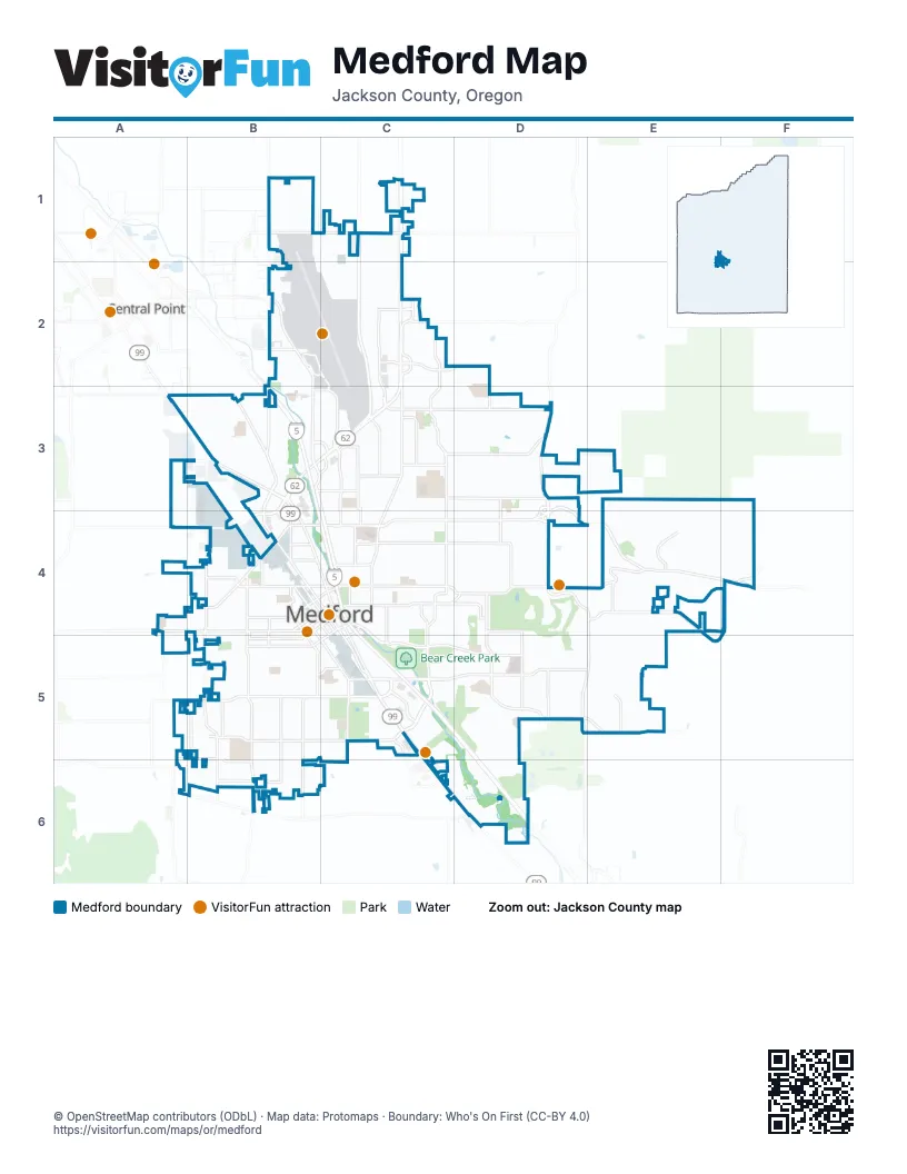
Street index of Medford
Each street on the sheet and the grid squares it crosses.
- Medford ViaductC4
- Crater Lake HighwayC1, C2, B3, C3
- Rogue Valley ExpresswayC1, C2, C3
- East Barnett RoadC5, D5, E5
- North Foothill RoadD3, D4
- Garfield StreetB5, C5
- South Pacific HighwayC5, C6, D6
- North Phoenix RoadD4, E4, D5, E5
- North Central AvenueB3, B4, C4
- East Vilas RoadB1, C1
- Rossanley DriveB3, A4, B4
- Highland DriveC4, C5
- North Riverside AvenueB3, B4, C4
- South Riverside AvenueC4, C5
- North Pacific HighwayA3, B3
- South Central AvenueC4, C5
- Court StreetB3, B4
- East McAndrews Off RampD3, D4
- East McAndrews On RampD3, D4
- South Stage RoadA6, D6
- North Foothill On RampD4
- North Foothill Off RampD4
- Riverside Avenute Connection #1B3
- East McAndrews RoadD3, B4, C4, D4, E4
- Biddle RoadB2, B3, C4
- Crater Lake AvenueC1, C2, C3, C4
- Hillcrest RoadC4, D4, E4, F4
- Delta Waters RoadC2, C3, D3
- West Main StreetA4, B4, C4
- South Columbus AvenueB4, B5, B6
- Table Rock RoadB1, B2, B3
- Stewart AvenueB5, C5
- East Jackson StreetB4, C4, D4
- East Main StreetC4, D4
- West McAndrews RoadA4, B4
- West 8th StreetB4, C4, B5
- Orchard Home DriveB5, B6
- Poplar DriveC3, C4
- Lozier LaneB4, B5
- Center DriveC5
- N Ross LnB4
- North Columbus AvenueB4
- Hilton RoadB3, C3
- West Stewart AvenueA5, B5
- East Stewart AvenueC5
- East 4th StreetB4, C4
- Cunningham AvenueB5
- East 8th StreetC4
- Sage RoadB3, B4
- West Table Rock RoadB3
- Elm StreetB4, B5
- McAndrews RoadE4
- Old McAndrews Road Off-rampB4
- Old McAndrews Road On-rampB4
- 5th StreetB4
- Cherry LaneD4, E4, F4, E5, F5
- Springbrook RoadC2, C3, C4
- Siskiyou BoulevardC4, C5, D5
- Spring StreetC4, D4
- South Holly StreetB4, C5, C6
- Roberts RoadC3, D3
- South Peach StreetB4, B5, B6
- Lone Pine RoadC3, D3
- Black Oak DriveD4, D5
- Juanipero WayD5, E5
- South Oakdale AvenueB4, B5
- Valley View DriveD3, C4, D4
- Owen DriveC2, D2
- Archer DriveB6
- Cedar Links DriveC3, D3
- Lear WayC2
- Stanford AvenueE4, E5
- Kings HighwayB5, B6
- Coal Mine RoadD5, E5
- Diamond StreetB6
- Roxy Ann RoadE3, F3, F4
- West 10th StreetC4, B5, C5
- Golf View DriveD5
- Coker Butte RoadC2
- West 2nd StreetB4
- Corona AvenueC3, C4
- North Keene Way DriveC3
- Murphy RoadD4, D5
- South Fir StreetB4, C4, C5
- Summit AvenueB4
- Brookdale AvenueD3, D4
- Bullock RoadC3
- Highcrest DriveE4
- West 4th StreetB4
- East 10th StreetC4
- Stevens StreetC4
- Hamilton StreetB4, B5
- Merriman RoadB3
- Beall LaneA3, B3
- Thomas RoadB5, B6
- West Jackson StreetB4
- Terminal Loop RoadB2, C2
- Whittle AvenueC3
- Happy Valley DriveB6
- Sunrise AvenueC4
- Airport RoadB2
- Grand AvenueC3
- Country Club DriveD4
- North Holly StreetB4
- Maple Park DriveB4
- Western AvenueB4
- Lawnsdale RoadB3, C3
- Sunset DriveA6, B6
- Pierce RoadD4
- Morrow RoadB3, C3
- North Fir StreetB4
- North Barneburg RoadC4
- McLoughlin DriveD2, D3
- Willamette AvenueC4, C5
- Royal AvenueC4
- West Barnett StreetB5, C5
- South Front StreetC4, C5
- North Front StreetB4, C4
- Monroe StreetB5, C5
- Wilson RoadB1
- Anton DriveC5
- North Oakdale AvenueB4
- West 6th StreetB4
- White Oak DriveD4
- Rose AvenueB4
- Edwards StB4
- Terminal Spur RoadB2, C2, C3
- Oak Grove RoadA4, A5
- South Barneburg RoadC4
- Mason WayA3, B3
- Cottage StreetC4
- East 12th StreetC4, C5
- Manzanita StB4
- Hawthorne StreetC4
- Ohio StreetB4
- East 6th StreetB4, C4
- Joseph StreetB3
- Airport EntranceB2
- Bradbury StreetC3
- Bursell RoadB3
- Acorn WayD4
- Airport ExitB2
- Bear Creek CorporationC6
- North Keeneway DriveC3, C4
- Aerial Heights DriveE4, F4
- Calle Vista DriveD4, E4
- Ford DriveC2, D2, C3
- La Loma DriveD5, D6
- South Grape StreetB4, C5
- Dakota AvenueB5
- North Berkeley WayC4
- West 11th StreetB5, C5
- North Modoc AvenueD3, D4
- South Ivy StreetB4, B5, C5
- Creek View DriveD5, E5
- Lowry LaneC6, D6
- Mace RoadA3, B3
- Tahitian AvenueC2, D2, C3, D3
- Ridge WayC4, D4
- Tamarack DriveE4
- Berrydale AvenueB3
- Dellwood AvenueC5, D5
- Myers LaneC5
- Stonebrook DriveD3
- Farmington AvenueD3
- South Modoc AvenueD4, D5
- Rogue Valley Manor DriveC5, D5
- Howard AvenueB3
- Arlington DriveB5
- Fieldbrook AvenueE4
- Innsbruck RidgeE4
- Skyline DriveD5, D6
- Vista Point DriveE4
- Rosewood StreetC3, D3
- Windsor AvenueD4, C5, D5
- Grumman DriveC1, C2
- Temple DriveC3
- Newtown StreetB4, B5
- Medical Center DriveD5
- Shamrock DriveD5, E5
- Crystal Springs DriveE4
- Alameda StreetD5
- Whitman AvenueC5
- East 9th StreetC4
- Cloudcrest DriveE4, F4
- Beatty StreetB4
- Chestnut StreetB4, B5
- Hathaway DriveE4, F4
- Ravenswood CreekD6
- West Prune StreetB5
- Aspen StreetB5
- Eagle Trace DriveE4
- Jasper StreetC5
- Woodlawn DriveC4, D4
- King StreetB5
- Sunleaf AvenueE5
- Agate StreetB6
- Cherry StreetB5
- Connell AvenueB3
- Oak StreetB4
- Mariposa TerraceE4
- Sky Park DriveC3
- West 13th StreetB5, C5
- Beekman AvenueB5
- Niantic StB4
- Kenyon StreetC5
- West 12th StreetB5, C5
- Haven StreetB4
- Manchester DriveA3, A4
- Plum StreetB5
- Brookhurst StreetC3
- Durst StreetC2, D2
- Arrowhead DriveC2
- Windgate StreetE5
- Hawaiian AvenueD3
- Stardust WayE4
- Cheltenham WayD2, D3
- Milligan WayB2
- Mira Mar AvenueD5
- Quail Point CircleD5
- Ellendale DriveC5
- Murrayhill CourtE4
- Park AvenueB5
- Capital AvenueC4, D4
- Pennsylvania AvenueB4
- Palm StreetB4
- Wabash AvenueC4
- Jeanette AvenueB4, B5
- Eastwood DriveC4, C5
- Crestbrook RoadC5, D5
- Johnson StreetC3
- Cirrus DriveB2
- State StreetD5
- Wolf Run DriveE4
- Meadowview DriveD5, D6
- South Groveland AvenueC4, C5
- Midway RoadB3
- Cheshire WayA3, A4
- Kerrisdale Ridge DriveD3
- Lone Oak DriveE4, E5
- South Keeneway DriveC4
- Veranda Park DriveD3, D4
- North Grape StreetB4
- Oregon AvenueC4
- North Bartlett StreetB4, C4
- Ellen AvenueA3, B3
- Lillian StreetB5, B6
- Winchester StreetB5
- Gene Cameron WayD3
- Seckel StreetD5
- Bateman DriveB1
- Dixie LaneB5
- Sycamore WayD3
- Meadows LaneB5
- Murray StreetB5
- West Clark StreetB4
- Normil TerraceD3
- Princeton WayD4, E4
- Shafer LaneB6
- Viewpoint DriveD3
- Angel Crest DriveE4
- Cardinal AvenueC2
- Village Center DriveD5, D6
- Serenity DriveC3
- Mount Pitt StreetB5
- East Jackson DriveD4
- Commerce DriveC2
- Hybiscus StreetC4
- Evergreen StreetB4, C4
- Kingswood DriveB3, B4
- Cherokee DriveC2, C3
- Stratford AvenueC4
- Autumn Park DriveF4
- Benson StreetB5
- International WayC2
- Leonard AvenueD3
- Bierson WayB1
- Gardendale AvenueD4
- Monterey DriveE4
- Torrey Pines DriveE4, F4
- Park Ridge DriveE4
- Village CircleD5
- Clover LaneB4
- Southvillage DriveD4, E4
- Kensington SquareD4
- Meadowcreek DriveD4
- Far West AvenueB3
- Queen Anne AvenueC4
- Lazy Creek DriveD5
- De Barr AvenueB3
- Mallard LaneC2
- Brookside DriveC3, D3
- Hollyhock DriveC2
- Olympic AvenueD5
- Woodbriar DriveC3, D3
- El Dorado DriveD5
- Westwood DriveA5, B5
- Kingsley DriveC1
- Wilkshire DriveD3
- Charlotte Anne RoadC5
Things to do on the Medford map
Places on the map
- Alder Creek Office Park
- Asante Rogue Regional Medical Center
- Avamere at Three Fountains
- Barneburg Hill
- Bear Creek Golf Course
- Bear Creek Park
- Bear Creek Plaza
- Bonaventure of Medford
- Buckshot Hill
- Cascade Christian High School
- CPU TIFFS HALLMARK
- Crater Lake Plaza
- Delta Center
- Donahue-Frohnmayer Park
- Fichtner Mainwaring Park
- First Baptist Church
- Fred Meyer
- Harry & David Field
- Hawthorne Park
- Hedrick Middle School
- Hillcrest Office Park
- Holmes Park
- Howard Elementary School
- Kennedy Elementary School
- Kennedy Park
- Larson Creek Shopping Center
- Lewis Park
- Lithia & Driveway Fields
- Medford Downtown Historic District
- Medford historic districts
- Navigators Landing
- North Medford High School
- Quail Point Golf Course
- Rogue Valley Country Club
- Rogue Valley International-Medford Airport
- Rogue Valley Mall
- Stewart Meadows Golf Course
- Stewart Meadows Village
- Village at Medford Center
Next to Medford
- Central Point
© OpenStreetMap contributors, Open Database License, openstreetmap.org/copyright · Map data: Protomaps · Boundary: Who's On First (CC-BY 4.0); Quattroshapes (CC BY 2.0)